
January 4, 2021

Osareni Ogiesoba
Delineating hydrocarbon sweet spot, lithology, and diagenetically altered zones in the Serbin field, Southeast Texas
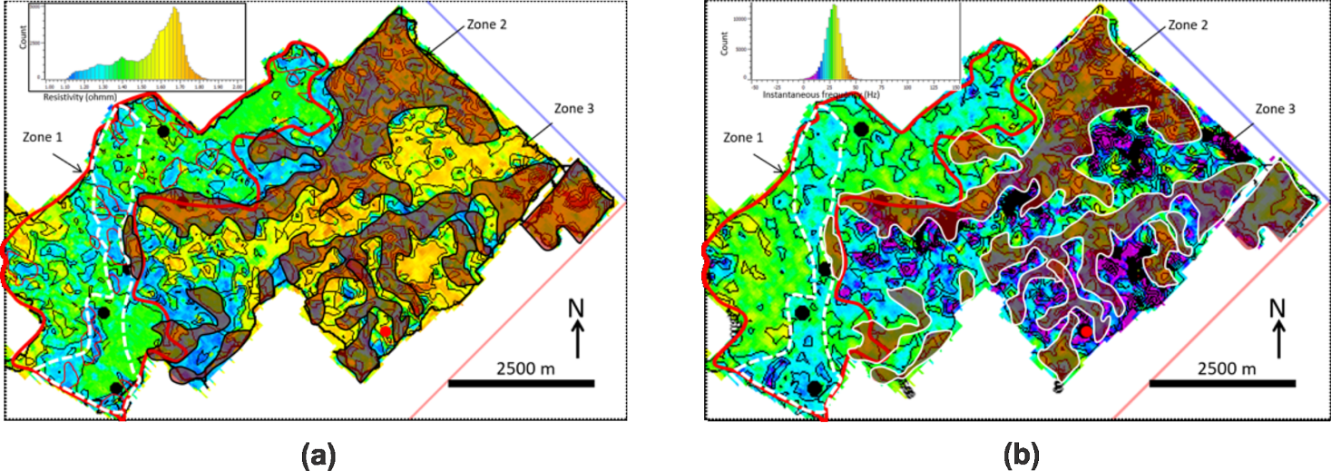
Fig. 1. Map of the east part of the Serbin field showing hydrocarbon sweet spots: (a) resistivity map with low-resistivity Zone 1, shale-rich Zone 2 (brown), and hydrocarbon-saturated, high-resistivity Zone 3 (yellow to red); (b) instantaneous-frequency map with moderate frequency Zone 1, shale-rich Zone 2 (brown), and low-frequency, hydrocarbon-saturated Zone 3 (magenta).
STARR program research activities range from reservoir characterization and core description to structural and stratigraphic studies. These activities are aimed at helping operators in the state of Texas locate hydrocarbon sweet spots within conventional and unconventional resource plays, and assisting their production efforts. In 2018 and 2019 (Ogiesoba et al., 2018; 2019), we discussed a step-by-step methodology for determining hydrocarbon sweet spots, lithology distribution, diagenetically altered zones, and depositional environments in the Serbin field of southeast Texas, which straddles parts of Lee, Bastrop, and Fayette Counties and covers approximately 56 mi2 (~90 km2).
Since the discovery of the Serbin field in 1985, no comprehensive 3D seismic-attribute work has been undertaken to determine hydrocarbon sweet spots or lithology distribution. By conducting seismic-multiattribute analysis and integrating wireline and core data, we were able to predict the distribution of hydrocarbon sweet spots and show that the reservoir beds are composed of storm-dominated shelf-sandstone deposits. We demonstrate that Serbin field is separated into two areas: (1) a diagenetically altered, high-frequency, high-gamma-ray, high-resistivity, and high-acoustic-impedance area in the west part and (2) a low-frequency, low-resistivity, low-gamma-ray, and low-acoustic-impedance area located in the east part. Further detailed analysis shows that the east part can be subdivided into three parts: (1) a low-resistivity, hydrocarbon-unsaturated zone, (2) a diagenetically altered, shale-rich zone that serves as a stratigraphic trapping mechanism, and (3) a low-frequency, relatively high-porosity, high-resistivity, hydrocarbon-saturated sandstone-rich zone (Fig. 1).
References
Ogiesoba, O. C., W. A. Ambrose, and R. G. Loucks, 2018, Application of instantaneous frequency attributes and gamma-ray wireline logs in the delineation of lithology in Serbin Field, Southeast Texas: A Case Study: Interpretation, vol. 6, no. 4, p. T1023–T1043, doi:10.1190/INT-2018-0067.1.
Ogiesoba, O. C., W. A. Ambrose, and R. G. Loucks, 2019, Investigation of seismic attributes, depositional environments, and hydrocarbon sweet-spot distribution in the Serbin field, Taylor Formation, Southeast Texas: Interpretation, vol. 7, no. 1, p. T49–T66, doi:10.1190/INT-2018-0041.1.

