
August 24, 2020
Jacob Covault
Depositional Systems of the Eastern Gulf of Mexico
The Gulf of Mexico hosts a wealth of natural resource potential, including sand, water, and hydrocarbons. Large petroleum accumulations are stored in sandy reservoirs along the continental margin in river deltas and submarine channels. Sediment from rivers can push deltas to the edge of the continental shelf and directly connect to submarine channels; this is how continental margins are constructed and how land-derived sediment and dissolved chemical loads enter the ocean.
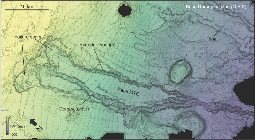
Structure map of a seismic horizon from the eastern Gulf of Mexico showing the interaction between shelf-edge deltas, failures, and slope channels.
However, the details and factors controlling the delta-channel connection remain elusive. In the Quantitative Clastics Laboratory, we used a large subsurface dataset to image and characterize the depositional systems just beneath the seafloor of the eastern Gulf of Mexico, where numerous shelf-edge deltas transition to submarine channels. We documented ancient landslides of the delta front at the shelf edge; the landslides established a seafloor "template" for the development of a submarine-channel network. Reconstructed sediment supply from ancient rivers controlled the initiation and scale of landslides and depositional systems.
These systems are analogs for older, deeper petroleum reservoirs in the eastern Gulf of Mexico and Atlantic petroleum basins. We can use these process insights from the present to better understand the past. Moreover, understanding the controls on submarine landslides and the resultant continental-margin architecture can inform environmental hazard assessments in the Gulf of Mexico.

Qian Yang
Managed Aquifer Recharge
Fusing an academic background in geophysics and an industrial background in data science, I have a keen interest in using both physics-based and data-driven approaches to understand how Earth's surface and interior are affected by anthropogenic activities and how to mitigate climate extreme events and disasters.
The first research project I conducted at the Bureau was quantify what volume of flood flows can be captured and stored in depleted aquifers in Texas for flood mitigation and drought preparation. This study shows that flood water in the Texas Gulf region totals ~30 maf from 2015 through 2017, corresponding to about twice the amount of water use in Texas in 2016 (14 maf). It is the first study to show that Texas has substantial amounts of excess water in volumes worth the effort of collecting. It also provided a quantitative foundation for the passing of House Bill No. 720, which allows unappropriated water—including flood water—to be appropriated for managed aquifer recharge (MAR).
Currently, I am working on a project granted by the Texas Water Development Board to integrate excess water availability analysis in evaluating the suitability of MAR. I am also interested in understanding and evaluating different risks associated with MAR to ensure its viability.
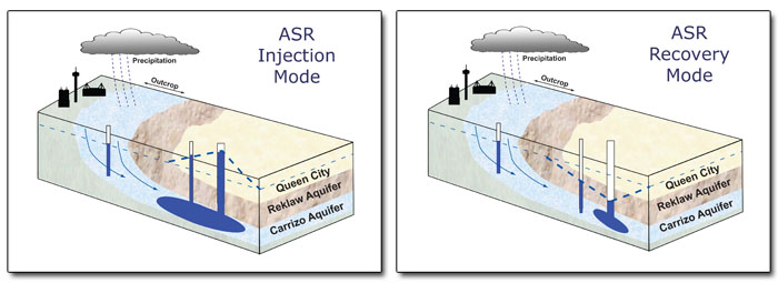
Courtesy of The Edwards Aquifer website.

