Texas Soil Observation Network (TxSON)
The Texas Soil Observation Network (TxSON) is a state-of-the-science network of stations designed to monitor soil water content, surface and ground water, and meteorological variables at various locations around Texas. The initial deployment in 2015 consisted of 40 stations within a ~36 km2 grid near Fredericksburg, TX, along the Pedernales River and within the middle reaches of the Colorado River. The network has since expanded to include stations to monitor weather and soil conditions in other areas of Texas, including the greater Houston area, Marfa, and Brady. Additionally, TxSON operates three stations that monitor water quality and spring flow at natural springs in West Texas, near Fort Stockton and Balmorhea, and two stations near San Antonio that measure the fluxes of water vapor and carbon dioxide (CO2) using the eddy covariance (EC) technique. TxSON serves as a Core Calibration and Validation Site for the National Aeronautics and Space Administration (NASA) Soil Moisture Active Passive (SMAP) mission, as well as the European Space Agency (ESA) Soil Moisture Ocean Salinity (SMOS) mission and Sentinel-1 satellites.

Mesonets, networks of weather and environmental monitoring stations, have become increasingly apparent as vital tools for understanding and managing water budgets and for predicting future environmental conditions, particularly as they relate to flooding and droughts.
The mission of TxSON is to ensure proper and robust operation of our mesonet in Texas. We do this by facilitating data transfer to collaborators and the public alike; maintaining data analysis procedures and communications with NASA, the National Weather Service (NWS), the Texas Water Development Board (TWDB) and other entities that compile and leverage raw data into specialized data products; and, by developing and implementing an approach that will produce a soil water content map of high spatial and temporal resolution. We want our products to be used by a variety of stakeholders, including those in the agricultural and ranching communities. TxSON is designed to provide:
- Refined soil water content products for operational use and improved forecasting.
- Improved drought management monitoring and irrigation water requirements.
- Data for utilities and industries to meet water, wind, and energy demands.
- Real-time emergency response data for natural disasters and environmental emergencies.
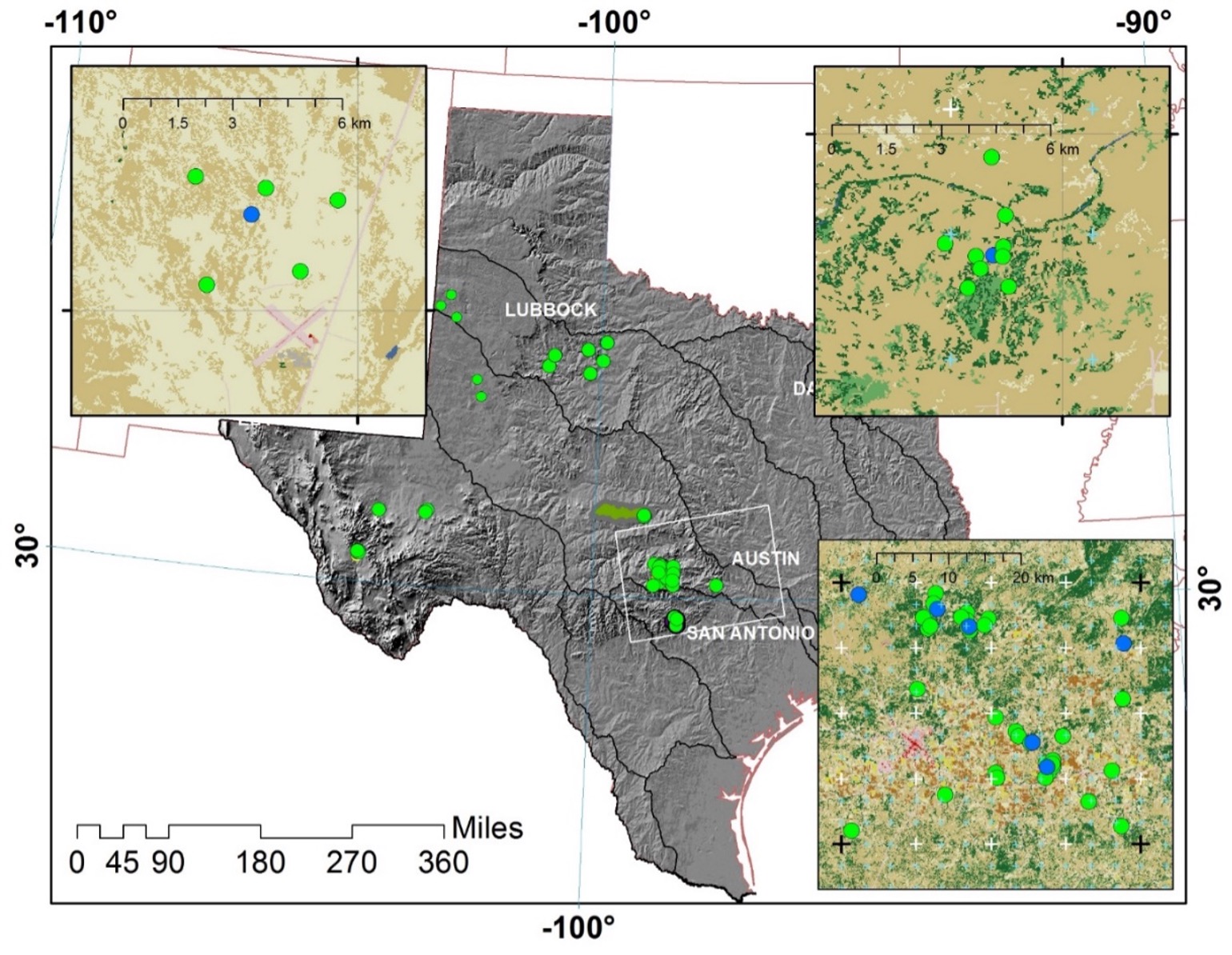
Locations of TxSON soil water content monitoring stations, as of July 1, 2022. Upper left inset shows close up for Marfa stations configuration. Upper right inset shows Brady station configuration. Lower right shows Fredericksburg installation.
What can you do?
Expansion and improvement of TxSON depends on external funding and collaboration. If you would like more information about funding a station, please contact: txson@beg.utexas.edu.
A single station requires a 10 x 10 foot fenced area and periodic access to collect soil samples and do routine maintenance on the sensor system.
To install a station, we auger a small hole (12 inches wide, 36 inches deep), install soil water content sensors into the side walls of the hold, and then backfill to grade. Meteorological sensors, a data logger and a cellular modem are added to a tripod on ground surface. The system is self-contained and powered by a solar panel. Data (soil water content and temperature, rainfall, air temperature and humidity) are automatically transmitted to an external server and are available in near real-time at https://www.beg.utexas.edu/research/programs/txson/map
TxSON participating partners:
