
August 10, 2020


Lily Horne, Peter Hennings & Chris Zahm
Basement Structure of the Delaware Basin and Central Basin Platform
The Permian Basin of Texas and New Mexico is an important petroleum province with a complex tectonic history. It also hosts a lot more earthquakes than it did a few years ago. Since the Proterozoic, this region has been shaped by several contractional and extensional tectonic events, each event influenced by the previously accumulated fault fabric through fault reactivation and strain-transfer. The result is a complex network of faults whose footprints compartmentalize the basin spatially and impact the present-day stress state. Constraining the geologic controls that influence the region’s stress state is vital for understanding how to stimulate reservoirs and when considering hazards related to seismicity, both induced and naturally occurring.
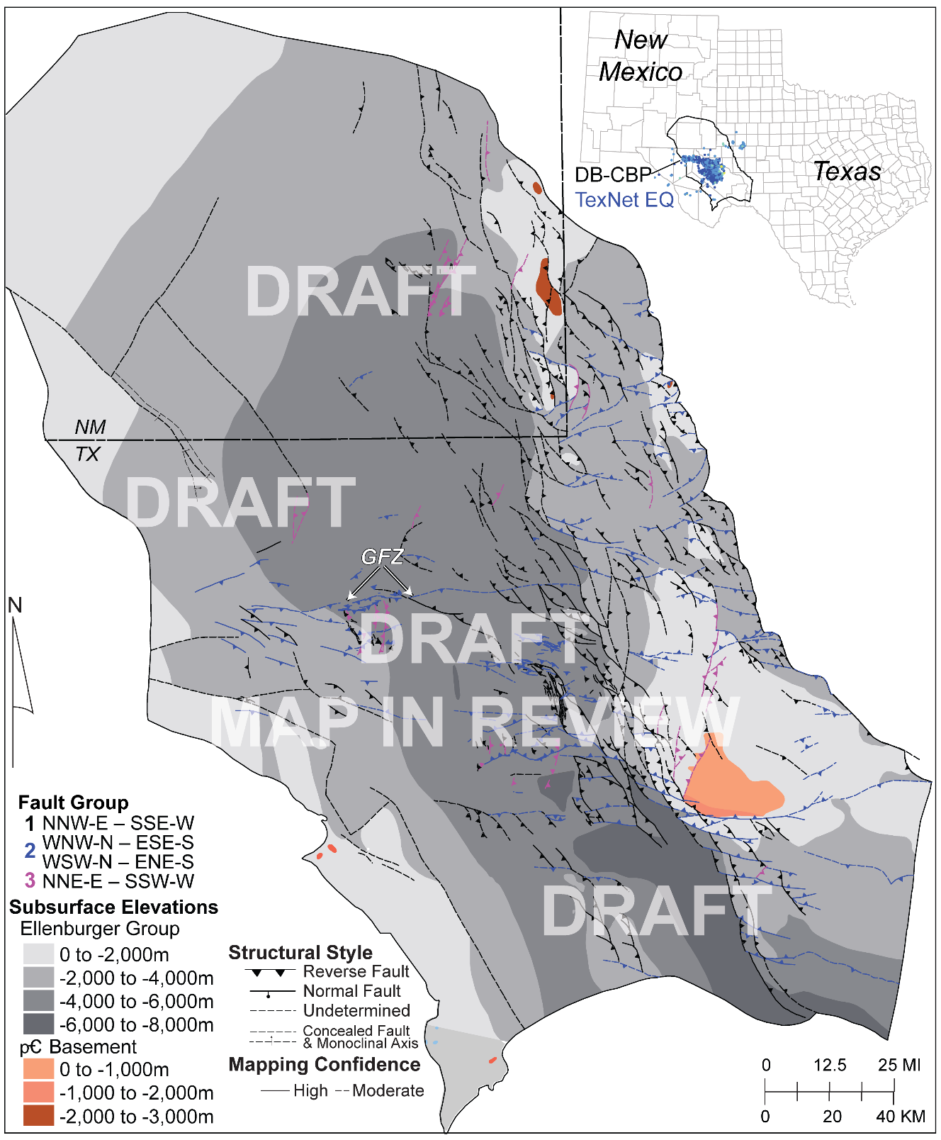
We have a new fault map of the Greater Delaware Basin and Central Basin Platform that enables basin-scale fault characterization and the identification of controlling fabrics. The focus of this map are basement-rooted faults which are interpreted as 3D surfaces. The map has more than 650 basement-rooting fault surfaces. A future phase of fault interpretation will focus on the shallower faults that pervade the basin proper.
This region is dominated by NNW–SSE trending primary structures, which make up 70% of the total faults. These NNW–SSE-oriented, high-angle reverse faults are compartmentalized by two secondary fault orientations that are observed regionally, most notable of which is the Grisham Fault Zone (GFZ). These secondary structural features are oriented E–W, have major dip- and strike-slip movement, include potentially reactivated fault-propagation folds and smaller scale oblique-slip fault zones, and are features that may have formed during transpressional strain. In some locations, this secondary fabric is accompanied by a third-order NNE–SSW fault set, which formed in association with accumulated transpressional strain. Fault interrelationship analyses suggest that the secondary E–W oriented fault zones are long-standing features that nucleated after the formation of the primary, NNW–SSE structural grain, compartmentalizing the basin, and the subordinate NNE–SSW structures are attributed to the reactivation of preexisting first- and second-order faults.
The results from this study will have significant utility for understanding the earthquakes observed to date and for assessing the future evolution of seismogenic hazard in the region.
These features are currently in external review for publication. Fault trace interpretations are subject to change, and finalized fault traces will be made digitally available as part of a Report of Investigations published by the Bureau of Economic Geology later this year.
Manuscript in review:
Horne, E. A., Hennings, P. H., and Zahm, C. K., (in review since July 2020), Basement Structure of the Delaware Basin, in Callahan, O. A., Eichhubl, P., eds., The Geologic Basement of Texas: A Volume in Honor of Peter Flawn. Bureau of Economic Geology, The University of Texas at Austin.
Lily Horne and Peter Hennings are researchers for TEXNET-CISR.
Chris Zahm is a researcher for RCRL.

Hongliu Zeng
River Chasing for Oilfield Development
Almost everyone who has flown on a commercial airplane has viewed the modern landscape through their window and been amazed at the beautiful form and geometry of geomorphic features such as river channels, deltas, barrier islands, and dune fields. These views represent modern surface snapshots of depositional systems. Seismic sedimentology has made it possible for us to recognize similar, but much older, depositional features preserved in 3D seismic data in the rock record. Sandstone reservoir bodies associated with such features are resolved when displayed on seismic-informed vertical stratigraphic profiles and horizontal geologic time surfaces, or stratal slices.
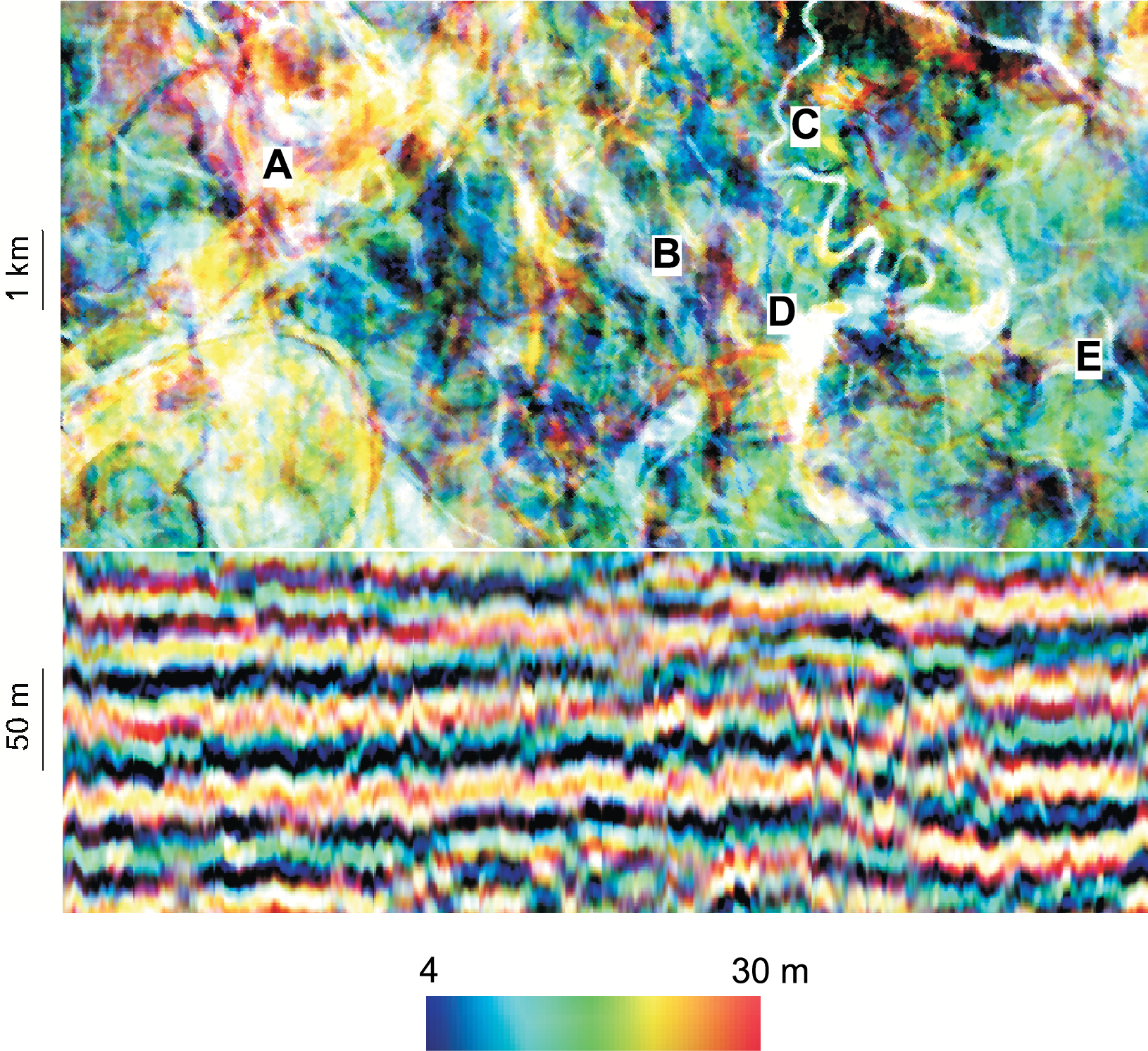
The image shown here is a seismic display from a 3D seismic volume in Bohai Bay, China, that delineates a main meandering fluvial valley (A) and many smaller channels (B–E).
The predicted porous, oil-producing sandstones range from 4 to 30 m thick, providing guidance to development of the highly-complex oilfield.

