
December 7, 2020

Katie Smye
Saltwater Disposal in the Delaware Mountain Group
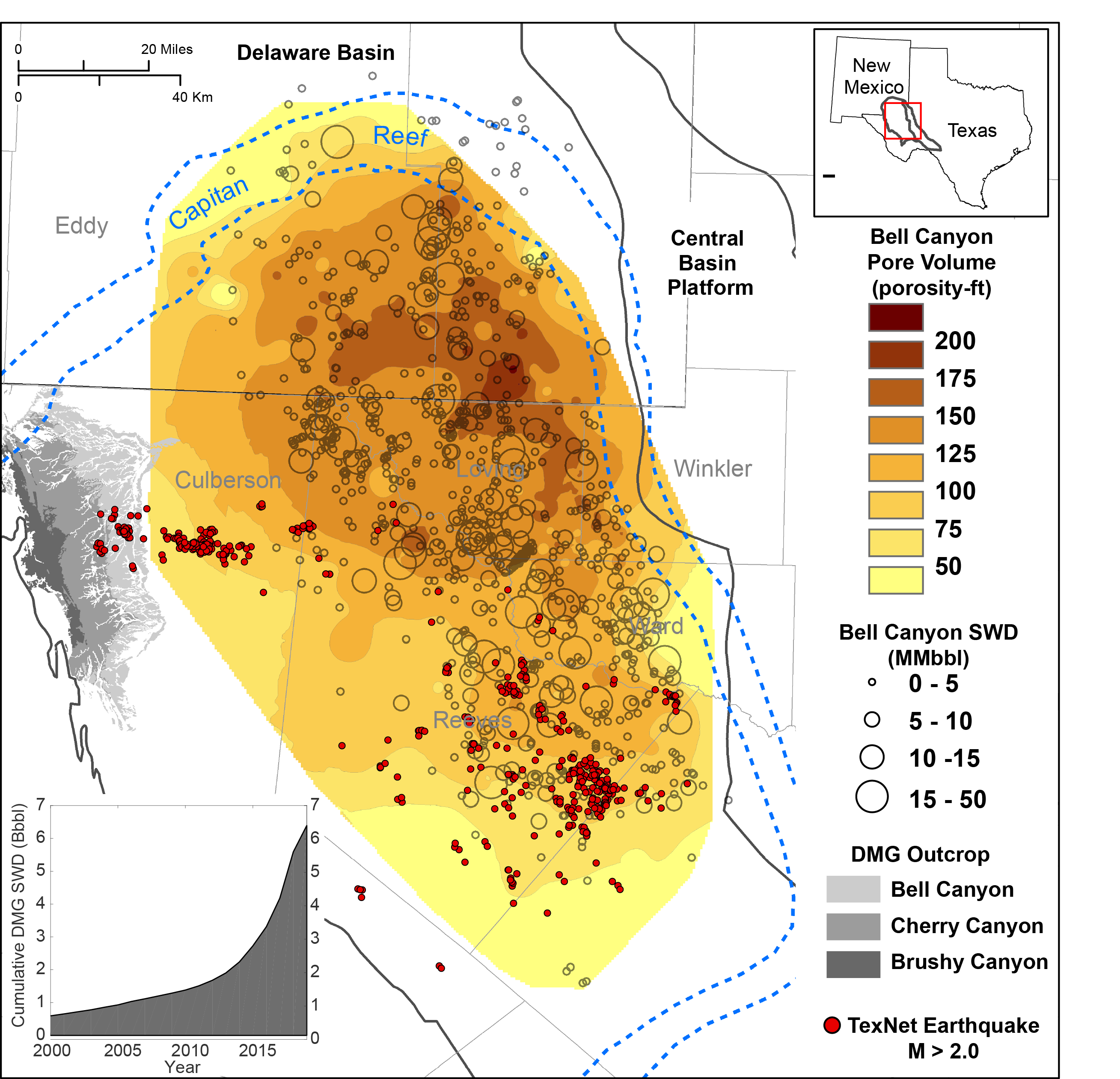
One challenge of unconventional oil production in West Texas is the management of water that flows back from hydraulic fracturing operations or is produced from the reservoir. Up to five times more water volume than oil is produced, and this water needs to be disposed of or recycled. Concerns about storage capacity and induced seismicity necessitate geologic characterization of the disposal intervals to understand how reservoir properties might impact the flow of injected fluid.
The Delaware Mountain Group (DMG) is the primary disposal interval in the Delaware Basin, with over 6 billion barrels of water disposed to date. Formations of the DMG are comprised primarily of sandstones deposited in a deepwater environment. Our group has been working to characterize these sandstones using subsurface data including cores and well logs, and mapping reservoir properties such as porosity, permeability, and sandstone connectivity.
In some areas of the basin—especially in southeastern Reeves County, Texas—there appears to be a relationship between increases in saltwater disposal into the Delaware Mountain Group and the shallowest of recent earthquakes as cataloged by TexNet. This characterization enables a hydrogeologic pore pressure history model of the Delaware Mountain Group, which helps us to investigate possible linkages to seismicity and assess the future capacity of the DMG as a saltwater disposal resource.

Tim Lawton
Evaluation of Supercontinental Sediment Pathways
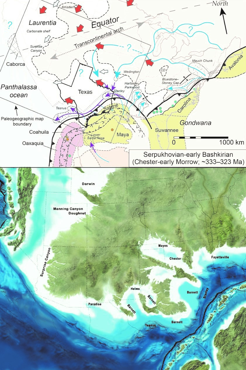
Sediment routing map (upper) and paleogeographic map by Ron Blakey (lower) for Late Mississippian time, early in the collisional history of Gondwana and Laurentia. Explanation: heavy barbed line, continent-continent collision zone; blue lines, river systems, purple lines, deep marine sediment delivery; thick blue arrows, inferred longshore currents; thick red arrows; modeled wind directions. Stippled patterns are important sediment accumulations (river deposits, deltas, deepwater deposits). Pale blue background indicates marine inundation of continent, darker blue is deeper water around continent's periphery. Upper map places paleoequator in horizontal orientation. Small text indicates key sedimentary formations; larger text labels south of collision zone are names of continental blocks thought to have collided with North America.
The supercontinent Pangea emerged over 70 million years ago when the world's major continental masses collided. Continental collision created mountainous highlands drained by major rivers, which delivered sediment to resource-rich sedimentary basins, such as the Permian basin of Texas. The composition of resulting sedimentary strata in these basins offers insight about the nature and timing of the mountain-building event and predicts which layers might be sources of water and natural resources or suitable repositories for storage of wastewater and greenhouse gases. Despite a growing compositional database, geoscientists in academia and industry continue to debate the origins and routes of sediment delivered across the growing supercontinent.
University of Texas scientists Tim Lawton, Danny Stockli (Department of Geological Sciences), and Li Liu have teamed up with Ronald Blakey of Deep Time Maps, Inc., to produce a clearer picture of evolving sediment routes to basins in Texas and elsewhere in Pangea. The synthesis involves integration of published literature with new compositional data from Texas and beyond produced in Stockli's UT Geo- and Thermochronometry Laboratory and will be published in an international journal.

