
April 5, 2021


Jacob Covault and Zoltan Sylvester
Time-lapse evolution of giant submarine channels offshore Brazil
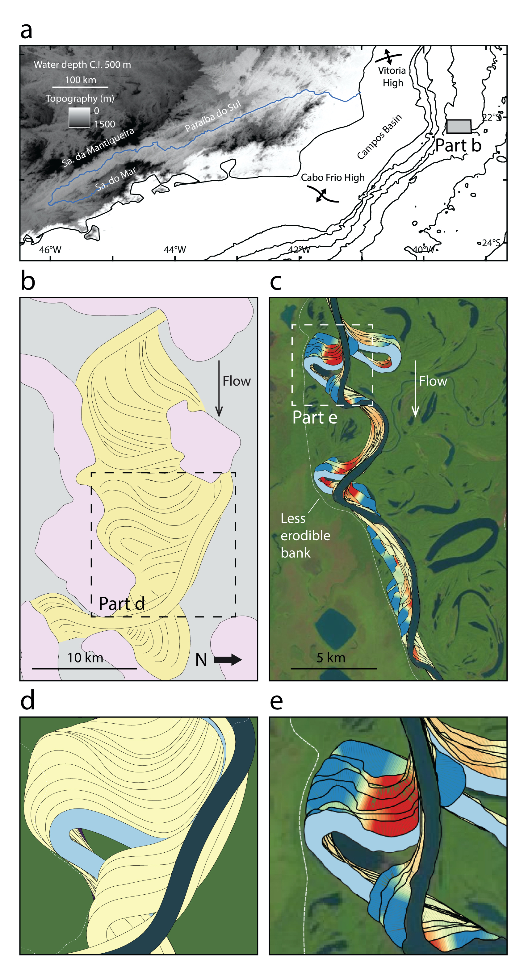
(a) Location map offshore Brazil. (b) Rotated line drawing of giant submarine-channel system. (c) For comparison, time-lapse evolution of meanders interacting with the bank of a river in the Amazon basin, Brazil. Present river is dark blue, cutoffs are light blue. Red-to-blue colors of predecessor channels indicate bar types resulting from river meandering. (d-e) Close-up of downstream translation of submarine (d) and river (e) channels against less erodible banks.
Submarine channels are like ‘underwater rivers’ through which sediment and pollutants, including microplastics, are transported across continental margins into the deep ocean. This land to ocean mass transfer governs the depositional evolution of coastlines and continental margins, and plays a role in the carbon cycle. Many offshore continental margins show submarine-channel patterns that resemble meandering rivers on land. How exactly do these underwater rivers evolve and disperse sediment and dissolved loads throughout the ocean? Do submarine channels migrate in a way that is similar to rivers? Whereas platforms like Google Earth Engine have enabled broadly accessible, global-scale analysis of rivers in Landsat imagery, this is difficult to do underwater. The company Investigação Petrolífera Limitada (PGS) shared 3D geophysical data with the Applied Geodynamics and Quantitative Clastics laboratories at the Bureau of Economic Geology to interpret the evolution of some of the largest submarine-channel systems ever recorded offshore Brazil. In addition to the giant submarine channels, the margin offshore Brazil has complex topography, with many salt domes that steer and deflect the submarine channels during tens of millions of years. We applied our experience in mapping and interpreting the time-lapse evolution of rivers in Landsat data to analyze the evolution of the submarine channels offshore Brazil. Our results show that early during the evolution of the submarine channel it migrated like a freely meandering river. However, as the submarine channel expanded toward nearby salt domes, its migration pattern fundamentally changed. With nowhere to expand further, the submarine channel translated downstream to produce a pattern characteristic in rivers that are confined by banks resistant to erosion. The animation shows this pattern of channel evolution. This study is one of few that offers perspectives of the time-lapse evolution of submarine channels similar to what is readily available for rivers on land. Changes in channel migration recorded in this time-lapse evolution can be used to understand the past deformation of salt domes and dispersal of sediment and pollutants across continental margins.
Time-lapse evolution of giant submarine-channel system offshore Brazil. Initial animation of channel migration from old (purple) to young (green-yellow). Pink polygons are salt domes. Later animation shows channel curvature (blue shading) and migration distance (green shading) from one channel centerline to the next. Red dots are points where the centerlines cross and dashed black lines help to show that the location of maximum migration is downstream of the bend apex.

