
Environment

The Environmental Research Division conducts a wide range of research in the geosciences. These topics include carbon sequestration; groundwater; geothermal energy; induced seismicity analysis, monitoring and mitigation; vadose-zone hydrology; coastal studies; life cycle costs of energy; geophysics; landscape processes; and geologic mapping. A critical aspect of all research is to avoid studying these processes in a vacuum and to understand how interconnected they truly are. Uniquely, Division researchers connect environmental systems to energy systems and economics—vital for understanding and addressing today’s complex issues. Its scientists have developed substantial strengths in the water/energy/land/economics nexus, and in big data/machine learning.
The Environmental Division investigates characteristics and processes of Earth’s crustal systems, and impacts of human activities on those systems. Many of its projects address the needs of Texas, although it also conducts research in other states, countries and continents. Our researcher professors collaborate with faculty, other researchers and students in the Department of Earth and Planetary Sciences and the Institute for Geophysics in the Jackson School of Geosciences, and across The University of Texas at Austin and beyond.
The Bureau of Economic Geology owns and operates an airborne laser terrain and bathymetric mapping system (lidar), a high-resolution 3D seismic imaging system, and substantial laboratory experimental facilities, and its researchers have access to the depth of resources at the Jackson School and UT-Austin. Environmental Division work is supported by a mix of government, philanthropic and industry (particularly research consortia members) funding.
CISR - Center for Injection and Seismicity Research
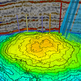
Texas, with its vibrant shale basin petroleum development industry, is home to Earth’s most active regions of human-caused earthquakes. CISR works to extend TexNet earthquake data to understand the geological conditions that host induced earthquakes, quantitatively understand the causes, and develop data and research that can be used for mitigation.
Coastal Studies
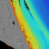
Research includes shoreline movement and beach and dune volumetrics studies along the Texas Gulf shoreline and in the bay systems, a collaborative research and educational beach monitoring program with coastal high school students and teachers, geologic mapping on the lower coastal plain focused on sand resources and Quaternary climate, wetlands status and trends studies, geoenvironmental studies of coastal state parks, and dating of Quaternary strata to better understand the geologic context of climate change.
Economic Mineral Resources Program
The Bureau has historically conducted research and published research and public information on economic minerals ranging from aggregates to metals and other minerals resources. The Economic Minerals Program conducts both geoscience research and analysis on resources and recovery as well as analysis of markets and applications.
Energy and Environment
New hydrologic and geomorphic studies that provide a framework for preserving the environment and remediating past damages related to energy development. The research provides technical expertise to the private sector to produce energy while protecting the environment through economically sound approaches.
Sustainable Water Resources
Water impacts from unconventional energy (Nicot, Scanlon)
Water use in electricity generation (Scanlon)
Access to Water and Energy
Energy-Water Nexus
The study of brackish water resources and water treatment, water use in energy exploration and production (mostly unconventional energy), and water use in the electricity generation sector.
Energy-Water Nexus research compilation
Geologic Hazards
We think of Earth as mostly benign and unchanging, but our planet is active on time scales ranging from seconds to millions of years. Some of these active processes constitute threats to humans and their homes, businesses, transportation modes, and recreational activities. Such threats are called geologic hazards, or geohazards. Bureau researchers apply geologic, geophysical, and remote-sensing methods to identify geohazards, assess their threat, and minimize their impact.
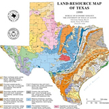
Geologic Mapping
The Bureau complements a strong tradition of field-based geologic mapping with cutting edge technologies to create surface and shallow subsurface maps and spatially referenced digital data sets to meet the applied and basic data needs of geoscience professionals, governmental agencies, and citizens.
Geologic Mapping
The Surface Casing Estimator Site
The Near Surface Observatory
The Bureau Store
Geological Sequestration of Greenhouse Gases
The Bureau seeks to impact global levels of atmospheric greenhouse-gas emissions by conducting studies on geologically sequestering CO2 in the deep subsurface, focusing on the Gulf Coast; educating the public about risks that might limit deployment and measuring the retention of CO2 in the subsurface; and enabling the private sector to develop an economically viable industry to sequester CO2 in the Gulf Coast area.
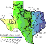
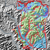
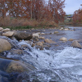
Groundwater Resources
Bureau research into groundwater resources looks at such practical questions as how much water can be pumped from an aquifer, how much recharge is there, and how much water will be left in 50 years. Researchers answer such questions via numerical modeling, original field research, and data collection and analysis.
Groundwater research compilation
State of Texas Rivers and Aquifers Water Storage (STRAWS) Dashboard
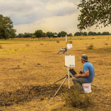
Landscape Processes
The Bureau studies landscape processes that occur in the very-near surface of the Earth (upper 2 meters), including evapotranspiration, soil erosion, ecosystem health and habitats, soil water recharge, and potential land impacts from a variety of activities.
Texas Soil Observation Network (TxSON)
Life-Cycle Environmental Analyses
The Bureau is studying the life-cycle environmental impacts of the supply chain and construction of electricity generating technologies, including natural gas combined cycle, wind and solar, with and without batteries. The results will provide a more holistic view and understanding of fossil and renewable energy systems.
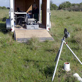
Near Surface Geophysics
The Bureau conducts studies focused on the surface and near-surface environment. Augmenting the efforts of researchers is a suite of airborne, surface, and borehole instruments that provide information on the physical properties of the near surface and allow researchers to conduct geologic mapping in diverse environments and studies on coastal hazards and geomorphic change, wetlands status and trends, coastal rookeries vulnerability, landscape characterization and evolution, periglacial landforms, soils, water bodies, and soil-moisture monitoring.

Near Surface Observatory
The Near Surface Observatory (NSO) is an aggregation of several research programs and researchers focusing on the surface and near-surface environment. Included under this umbrella are coastal studies, geologic mapping, near-surface geophysics (surface, airborne, and borehole), airborne lidar and its applications, geologic hazards, economic geology, drone-based imagery and topography, and surface-casing guidance for groundwater protection.

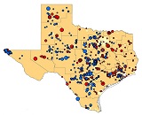
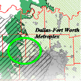
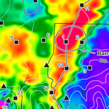
TexNet Seismic Monitoring Program
The TexNet Seismic Monitoring Program was established to locate and determine the origins of earthquakes in Texas, and, where possibly caused by human activity, with helping to prevent earthquakes from occurring in the future. As part of the program, the TexNet research team has developed the TexNet Earthquake Catalog, a dynamic mapping web page that provides information on the location of monitoring stations and recorded earthquakes across the state.
Vadose Zone Hydrology
The Bureau has unique capabilities in characterizing the vadose zone. Soil studies and the vadose zone program are comprehensive and include the use of physics, chemistry, isotopes, and numerical modeling to characterize the direction and rate of water movement and contaminant transport.
Vadose Zone and Soil Studies compilation
Texas Soil Observation Network (TxSON)
Water, Landscape, and Species Studies
The Bureau studies how aquatic and terrestrial habitats, some of which may be protected by State and/or Federal programs, intersect with economically important water, energy, and land resources. Our interdisciplinary approach integrates hydrology, geology, energy resources, landscape ecology, biology, and economics to provide unbiased, scientifically rigorous research solutions to stakeholders with the goals of facilitating species conservation, balancing continued economic growth, and providing stakeholders with the information and assistance they need to develop strategies to prepare for a possible listing.

