
July 6, 2020

Osareni C. Ogiesoba
Studying the Permian Basin’s Eastern Shelf
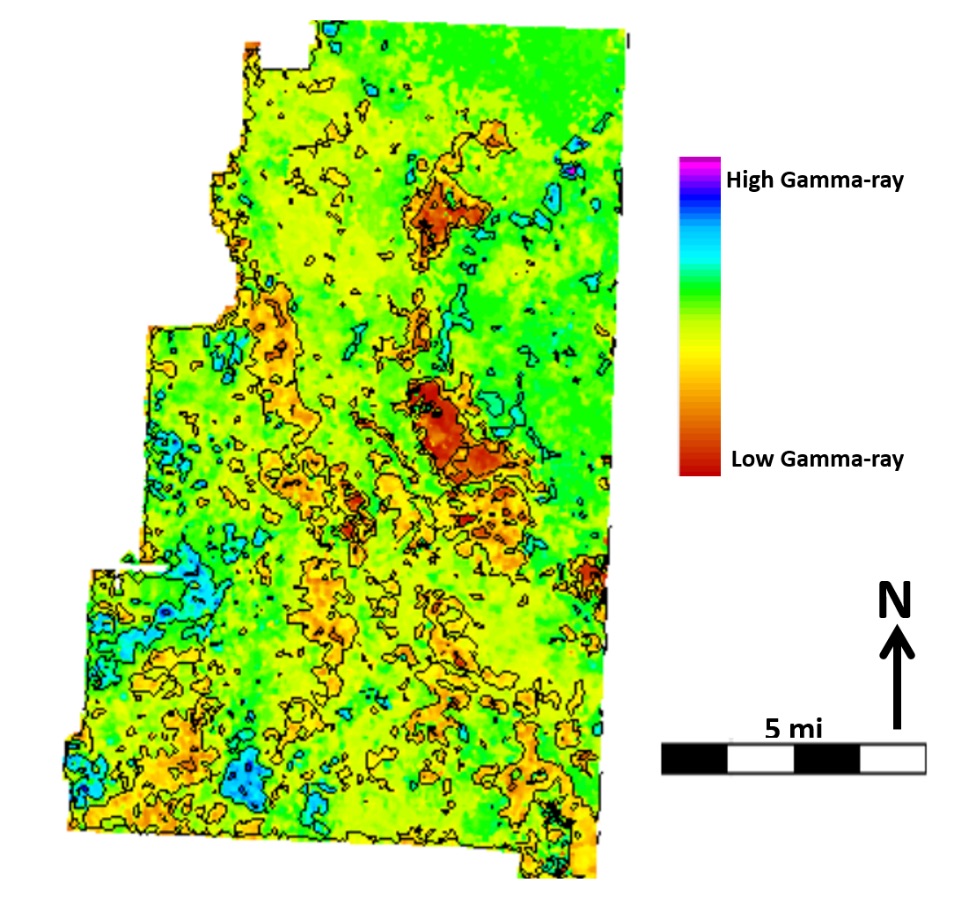
Gamma-ray map from the Eastern Shelf showing lateral distribution of lithology.
Osareni “Chris” Ogiesoba is investigating the sedimentary basins of the Eastern Shelf separating the Fort Worth and Permian Basins in central Texas. These basins formed during the Ouachita Mountain building process, some 360 to 320 million years ago. During this period, the Permian Basin became separated into the Delaware and Midland Basins by the Central Basin Platform. Between 320 and 286 million years ago, the basins became filled with different types of sedimentary rocks ranging from shale to sandstone to limestone. These rocks host more than 100 billion barrels of oil, but they have been complexly deformed by tectonic activity over time. We must understand the spatial distribution of the rock types before we can extract the oil.
As a research geophysicist with the State of Texas Advanced Resources Recovery (STARR) program at the Bureau of Economic Geology, Chris is interested in identifying oil and gas deposits within these basins. To accomplish this, he uses neural networks—or sets of algorithms designed to identify patterns much like our own brains do—combined with 3D seismic and wellbore data. Together, these tools can determine the distribution of rock properties such as impedance, gamma-ray, and density, which help reveal the locations of oil deposits within the basin.

Michael V. DeAngelo
CO₂ Trapping in the Gulf of Mexico
Michael DeAngelo is a Research Scientist at the Bureau of Economic Geology. His current research interest is locating suitable subsurface rock formations that can be used to permanently store CO₂ emitted from factories, refineries, and power plants. Storing CO2 underground can reduce the rate of global warming.
Where are we looking?
We are searching the entire offshore/onshore area of the Gulf of Mexico to identify any spots that can be used to permanently store CO₂, and help slow the global warming trend. We concentrate on areas with large industrial hubs, like the Port of Houston, Corpus Christi, and Sabine Pass. We envision capturing the CO₂ being emitted into the air and sending it via pipeline to a location either on land several miles off the coastline.
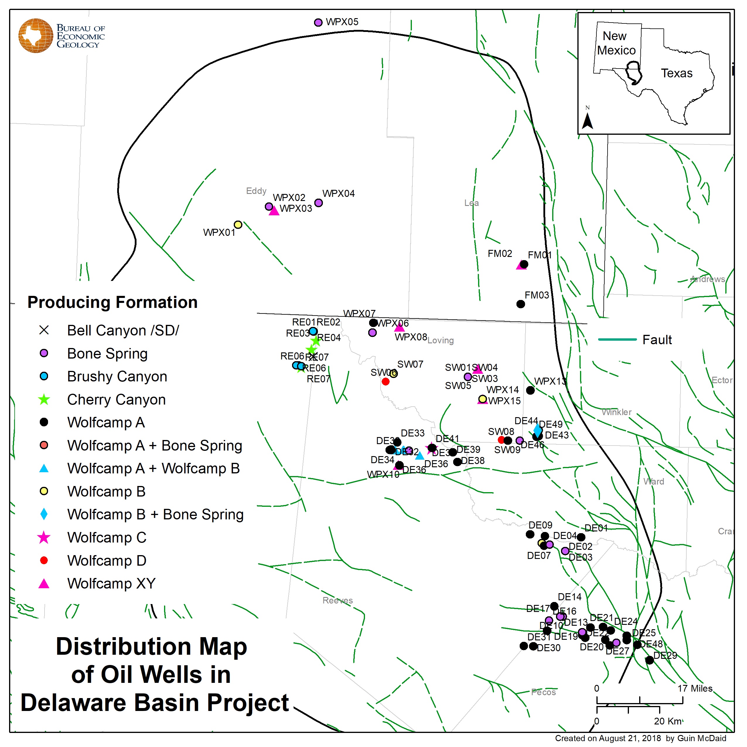
Map showing fractured wells in the Delaware Basin. This work is part of a statewide GIS project, and a related manuscript is in progress.
How do we locate a suitable location?
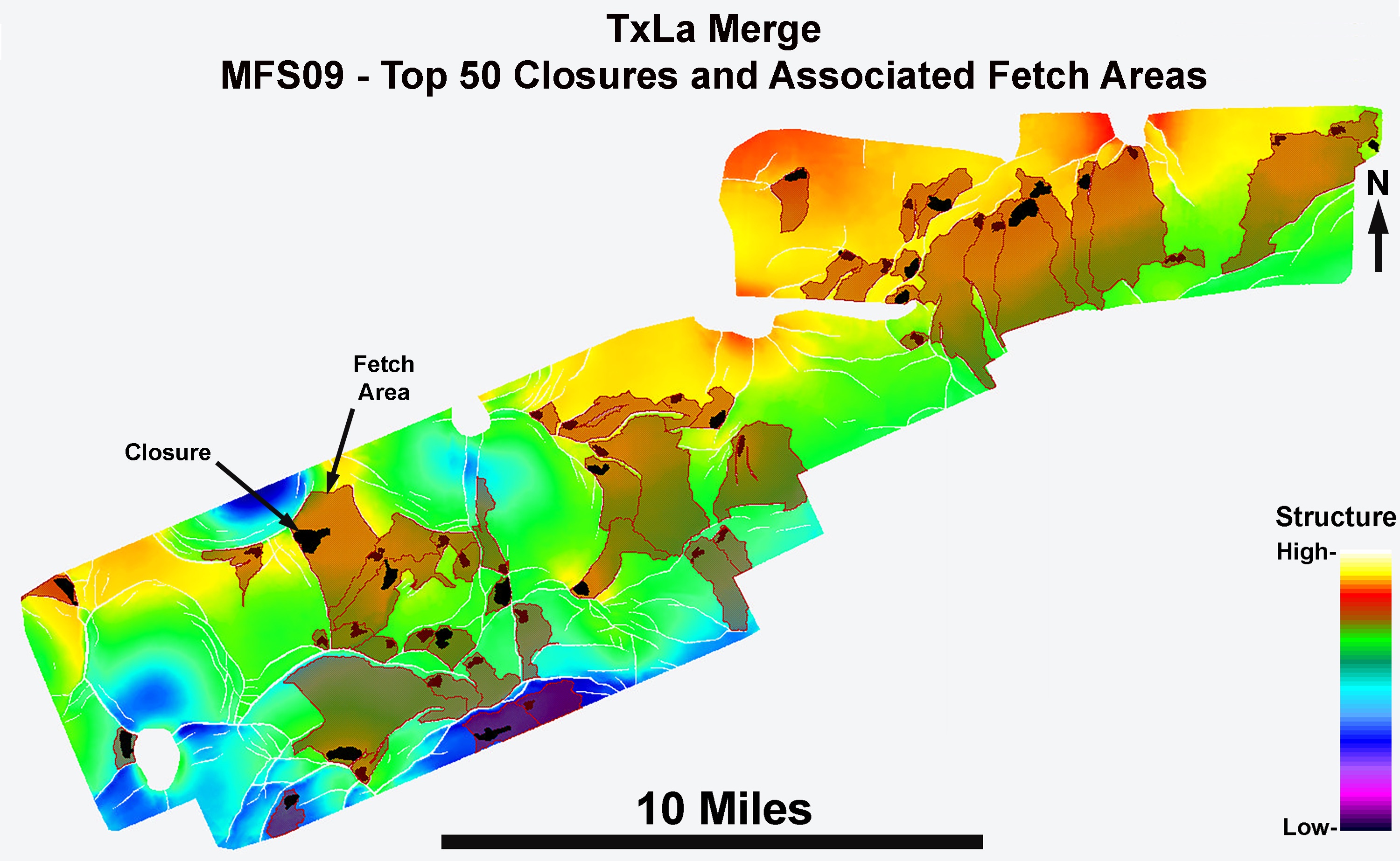
We take information from wells that have already been drilled while looking for oil and gas, and we add it to seismic data—data recorded using sound waves. We can use seismic data to image the subsurface in detail, much like we can use MRIs to image inside of our bodies. We use these images to pick a feature and map it. We then look for places on this mapped surface that are generally higher in relief (structure) or closer to the earth’s surface. These zones are traditionally where oil and gas have accumulated and been extracted with wells. Now we can us these same features to put captured CO₂ back into the earth to be stored or trapped permanently!
How does CO₂ trapping work?
We can use “closure” areas several thousands of feet below the surface of the earth to trap CO₂ gas. We fill the closures by injecting CO₂ into “fetch” areas first. The injected CO₂ will eventually move into the closure area, permanently trapping the CO₂.


Tongwei Zhang & Xun Sun
Produced Oil Geochemistry and Key Controls to Oil Quality Heterogeneity in the Delaware Basin
The Delaware Basin is a multi-source, multi-layered petroleum system. Therefore, it is critical to identify its single-source production wells and collect representative samples to investigate the following areas of study:
- the contribution of oil mixing from different sources in production
- the controls to crude quality heterogeneity, including thermal maturity and organofacies variation
- the paths and timing of oil migration
- changes in oil composition throughout production and indications predicting production decline
The Bureau of Economic Geology is conducting a sampling program that gathers 1-gallon samples from 100 Delaware Basin wells spanning a wide geologic range. The Bureau is also conducting a time-series sampling program that measures oil production time from 1 to 2 wells representative of different production times from the Bone Springs and Wolfcamp Formations. The 2-year-long research project benefits from industry funding and joint collaboration with seven operators who have provided crude oil samples from their own acreages.
This study will measure the geochemical fingerprints and physical properties of the crude oil samples. Our goal is to deliver an interpretation of spatial heterogeneity for Bone Springs and Wolfcamp crude and the key geochemical controls on a basin-wide scale. This study can identify value-added properties based on crude type and potentially enhance the value of operators’ product.

