
Van Vleck High School
School Website: https://high-school.vvisd.org/
2024-2025 field trip data: VanVleckHS2025.pdf
Galleries: 2017-2018 | 2018-2019 | 2019-2020 | 2020-2021 | 2021-2022 | 2022-2023 | 2023-2024 | 2024-2025 | 2025-2026
Van Vleck High School students collect data at MAT01, which is adjacent to a washover channel—Three Mile Cut (Fig 1). The washover channel is a low-lying area of the peninsula that is periodically opened between the Gulf of Mexico and East Matagorda Bay during major storms such as hurricanes. Van Vleck and Palacios High School students also collect GPS vegetation line and shoreline data at MAT03 (Fig. 1), a site adjacent to the Matagorda Bay Nature Park fishing pier and on the updrift side of the jetty at the mouth of the Colorado River.
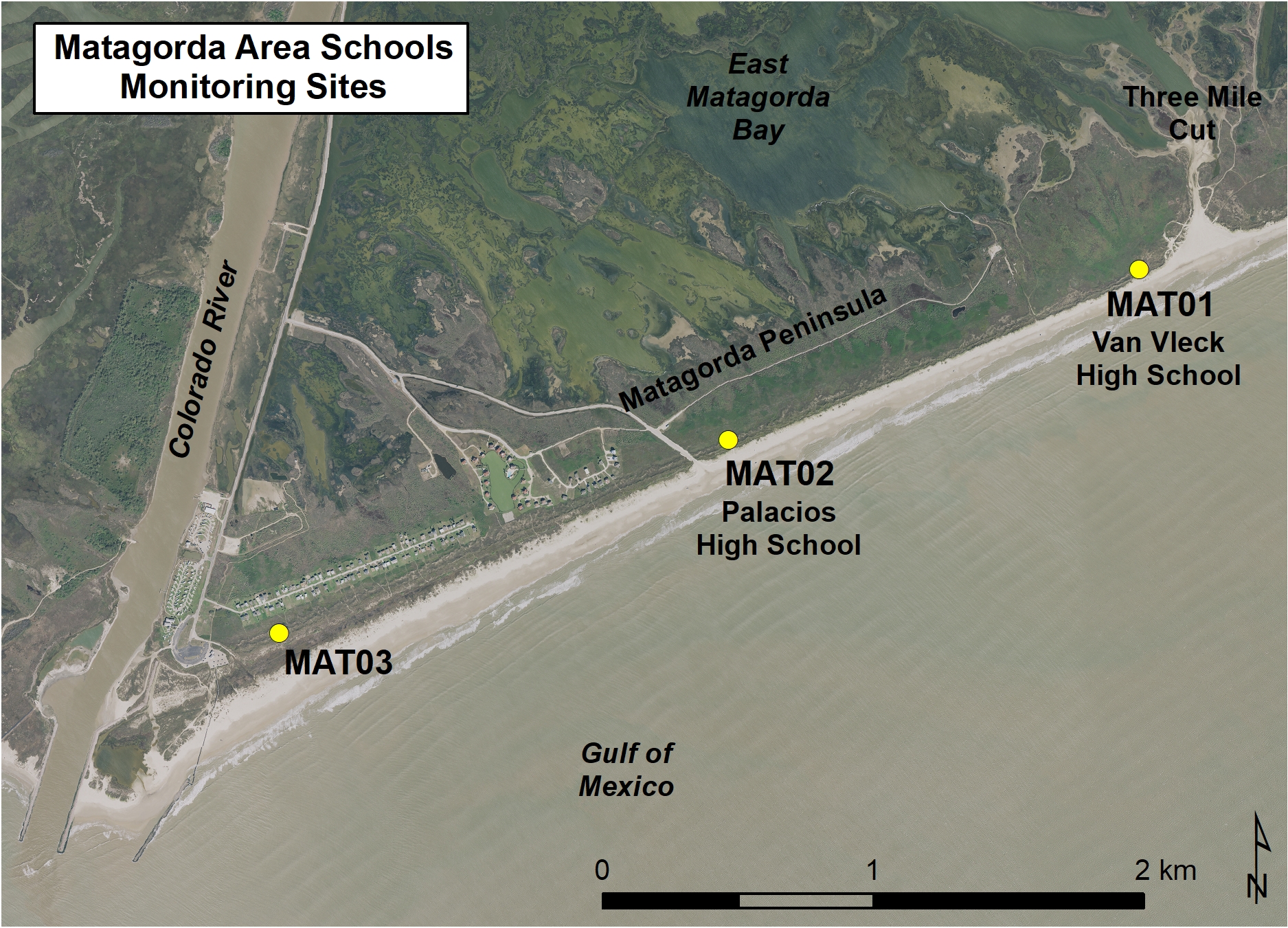
Figure 1. Location map of Van Vleck monitoring sites MAT01 adjacent to Three Mile Cut and MAT03 near the mouth of the Colorado River.
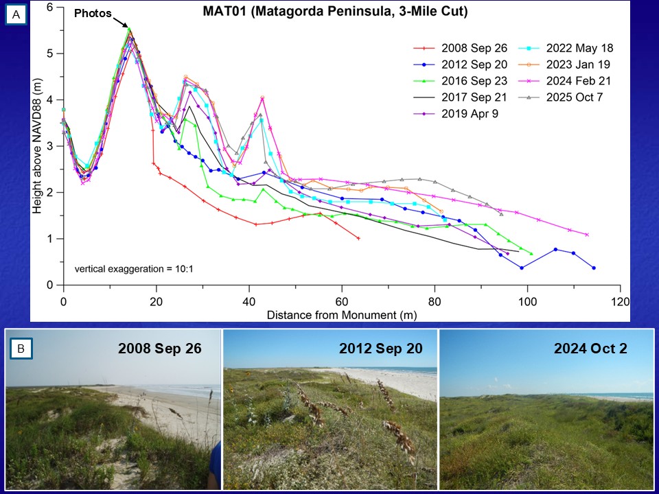
Figure 2. Changes to the beach and dune system at MAT01 on Matagorda Peninsula. (A) Beach profile plot showing the seaward expansion of the dunes between September 2008 (Post-Hurricane Ike) and October 2025. (B) Series of photos from September 26, 2008; September 20, 2012; and October 2, 2024 showing the seaward movement of the vegetation line and shoreline and expansion of the dunes. All three photos were taken from the primary dune crest looking northeast toward Three Mile Cut (noted in A).
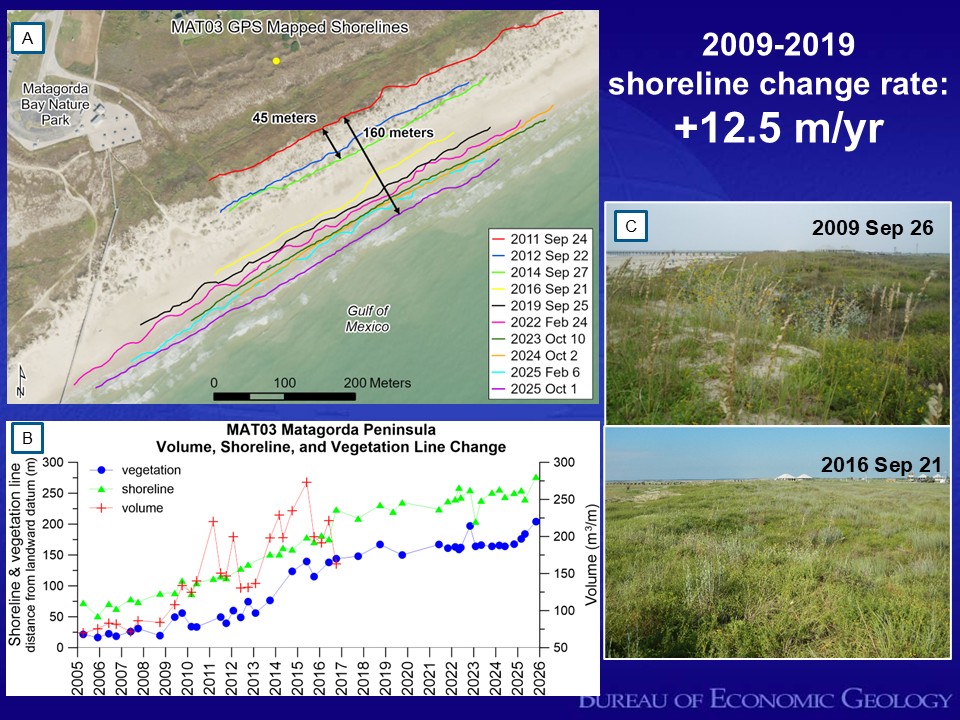
Figure 3. Changes at location MAT03 at Matagorda Bay Nature Park due to the construction of a jetty at the mouth of the Colorado River. (A) GPS mapped shorelines from September 2011 through October 2025. The mapping has documented that the shoreline position at MAT03 moved 125-m seaward over a decade (2009-2019) at an average rate of 12.5 m per year. The shoreline position has continued to move seaward between 2019-2025, but at a slower rate. (B) Shoreline, vegetation line, and beach profile volume change. Notice that the shoreline and vegetation lines have stabilized after a decade of advancement. (C) September 26, 2009 and September 21, 2016 photographs looking southwest toward the Colorado River along the dune crest at MAT03. Note the increase in the coppice dune area seaward of the dune crest in the 2016 photograph.


.png)

