
Port Isabel High School
School Website: https://www.pi-isd.net/o/pihs
2024-2025 field trip data: PortIsabelHS2025.pdf
Galleries: 2017-2018 | 2018-2019 | 2019-2020 | 2020-2021 | 2021-2022 | 2022-2023 | 2023-2024 | 2024-2025 | 2025-2026
Port Isabel students collect data at three profile locations on South Padre Island: SPI01 in Isla Blanca Park, SPI02 at Beach Access #13 (Moonlight Circle), and the newest site, SPI08, at the Tiki Condominiums (E. Whitesands Street) (Fig. 1). Port Isabel High School has been measuring SPI01 and SPI02 since 1999, and SPI08 since 2007. Brazos Santiago Pass, the southern border of South Padre Island, serves as the southern Gulf of Mexico access to the Gulf Intracoastal Waterway and the Port of Brownsville. Sediment dredged from the pass is used to nourish the beaches of South Padre Island. The use of sediment dredged from the pass for beach nourishment or other restoration projects is called beneficial use of dredged material or BUDM. The three sites monitored by Port Isabel High School students are typically within or adjacent to these nourishment areas.
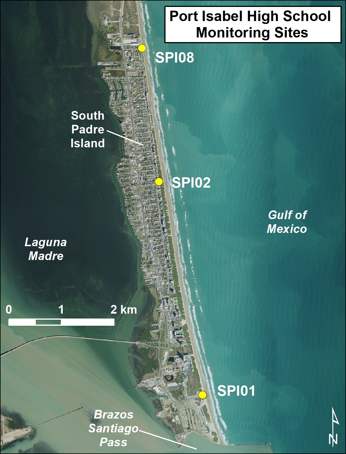
Figure 1. Location map of Port Isabel High School monitoring sites.
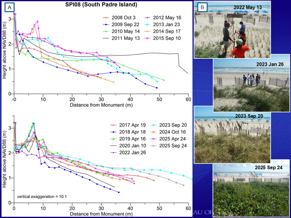
Figure 2. SPI08 is a chronically eroding location in front of the Tiki Condominiums near the north end of the city. This site has a narrow beach backed by a retaining wall and regularly receives nourishment sand from road maintenance north of the City of South Padre Island and from the dredging of Brazos Santiago Pass. (A) Profile plots showing changes in the beach topography at SPI08. The changes in the profile’s shape follow a pattern of beach nourishment to expand the beach seaward, vegetation plantings or creation of an artificial dune near the retaining wall, followed by a period of erosion and removal of the sand and plants at the wall. (B) Series of photos from the retaining wall looking seaward taken on May 13, 2022: January 23, 2023; September 20, 2023; and September 24, 2025 documenting the performance of the sand fencing installation and vegetation planting project completed in early 2022. This project has performed well with the dune volume increasing and vegetation growing and expanding.
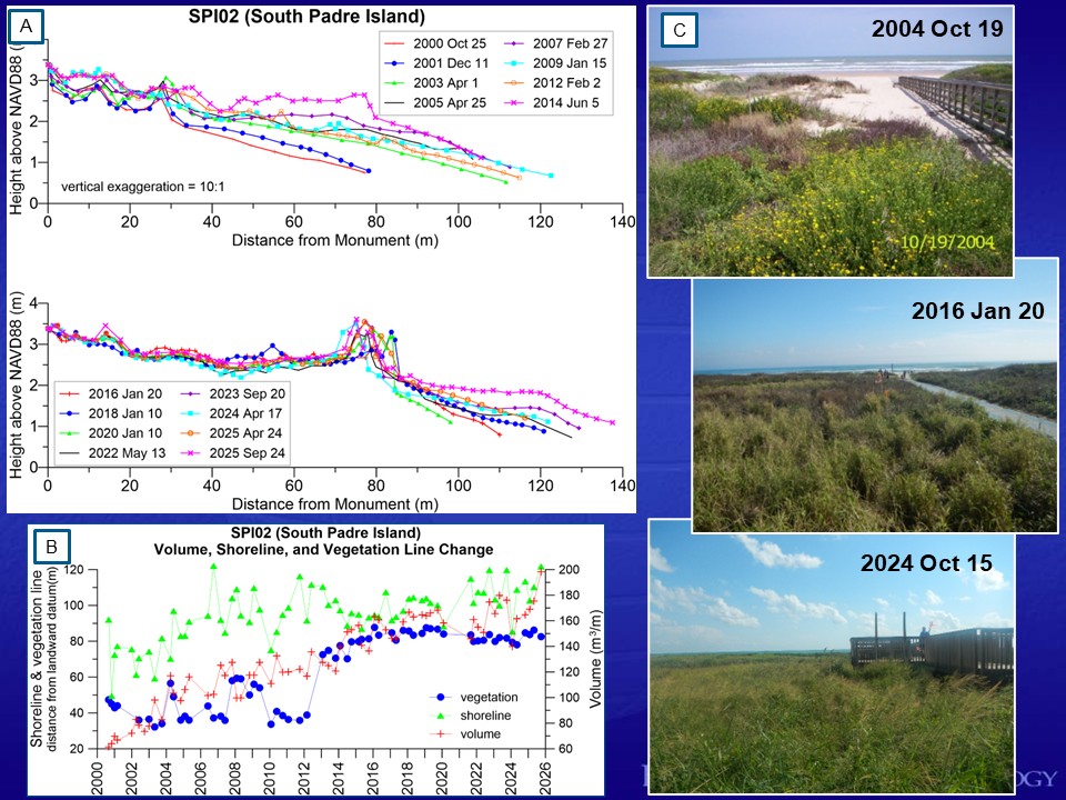
Figure 3. Changes at SPI02 on South Padre Island between 2000 and 2025. SPI02 monitoring site has been used to monitor the growth of dunes (sand volume) and shoreline movement. When SPI02 was established, there were no dunes between the retaining wall and waterline. Student collected data has been quantifying the effects of the installation of sand fences, planting of vegetation, beach maintenance practices, and BUDM nourishment projects. (A) Beach profile data and (B) volume, shoreline and vegetation line change plot documenting an overall trend of shoreline advancement and sediment-volume increase throughout the study period. (C) Series of photos looking seaward from the retaining wall from October 19, 2004; January 20, 2016; and October 15, 2024.
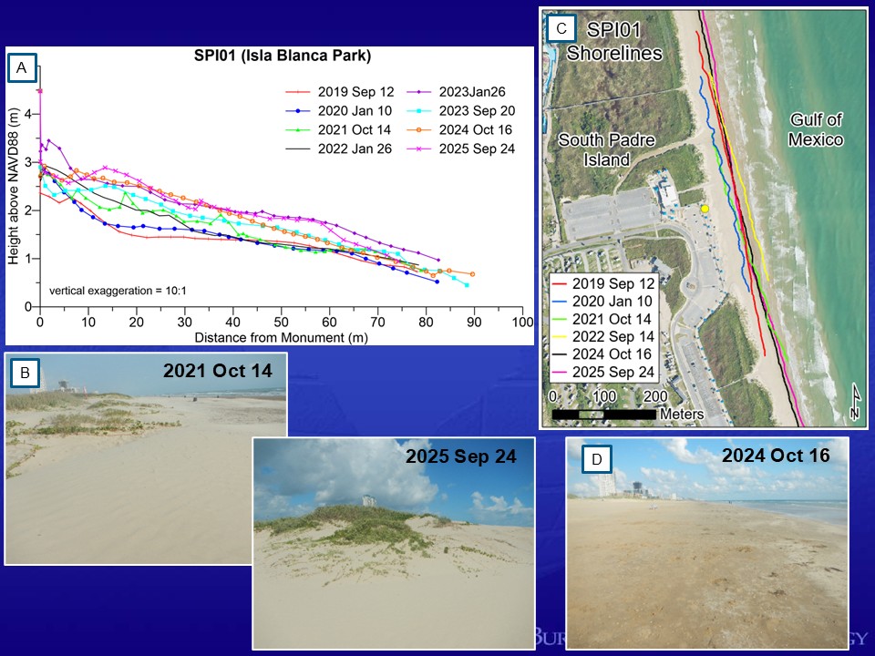
Figure 4. Data collected by Port Isabel High School Students at SPI01 in Isla Blanca Park. (A) Beach profile data collected by PIHS between September 2019 and September 2025. (B) Photos from October 2021 and September 2025 showing the growth of the dunes adjacent to the profile site north of the new boardwalk in Isla Blanca Park. (C) GPS mapped shoreline positions from September 2019 through September 2025. (D) Photo taken October 16, 2024 looking north along the wet/dry line (GPS mapped shoreline) at SPI01.


.png)

