
High Island High School
School Website: http://www.highislandisd.com
2024-2025 field trip data: HighIslandHS2025.pdf
Presentation by Jordan Grubbs at the Children’s Environmental Literacy Foundation (CELF) Student Symposium on March 11, 2022
Galleries: 2016-2017 | 2017-2018 | 2018-2019 | 2019-2020 | 2020-2021 | 2021-2022 | 2022-2023 | 2023-2024 | 2024-2025 | 2025-2026
High Island High School joined THSCMP in early 2016. Science students collect data from three sites on Bolivar Peninsula. Two of the monitoring sites are adjacent to Rollover Pass, BOL02 to the west and BOL03 to the east of the Pass (Fig. 1). The third site (HIB01) is seaward of High Island just past the eastern end of Highway 87 (Fig. 1).
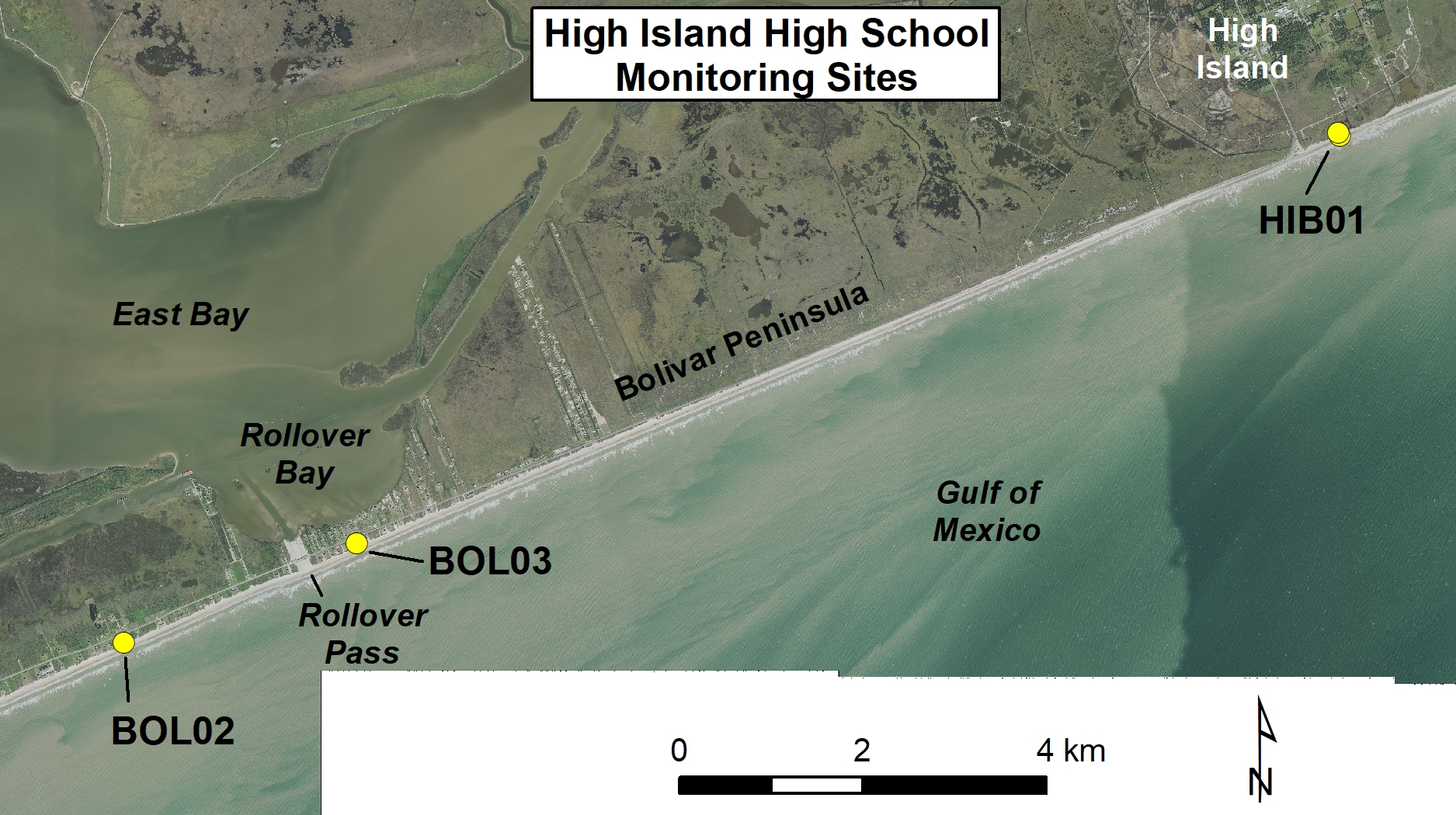
Figure 1. Location map of High Island High School monitoring sites.
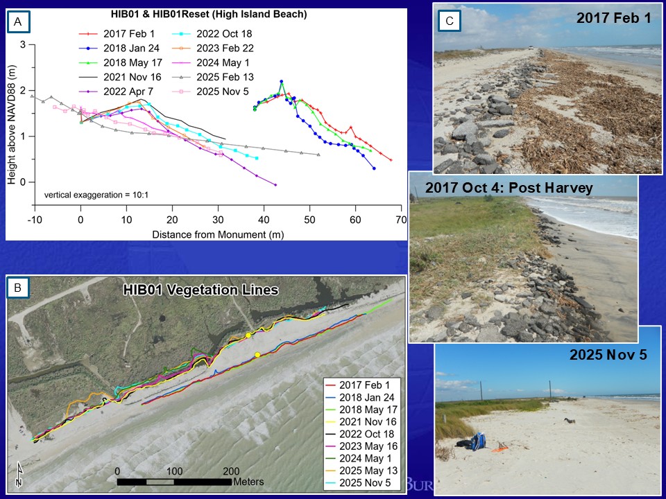
Figure 2. Changes to High Island Beach site HIB01. (A) Beach profiles showing topography changes and (B) GPS mapped vegetation line positions between February 2017 and November 2025. The original profile datum was lost between 2018 and 2021 and reset during the November 2021 field trip. During that time, the shoreline moved landward 25 meters (just landward of the original profile datum location), and the vegetation line moved 45 meters landward, due in part to the impacts of the 2020 hurricane season. (C) Photography documenting the status of the shoreline and vegetation line on February 1, 2017; October 4, 2017 (post-Harvey); and November 5, 2025. Notice the pavement debris that was at the berm crest in early 2017 was deposited at the vegetation line by Hurricane Harvey.
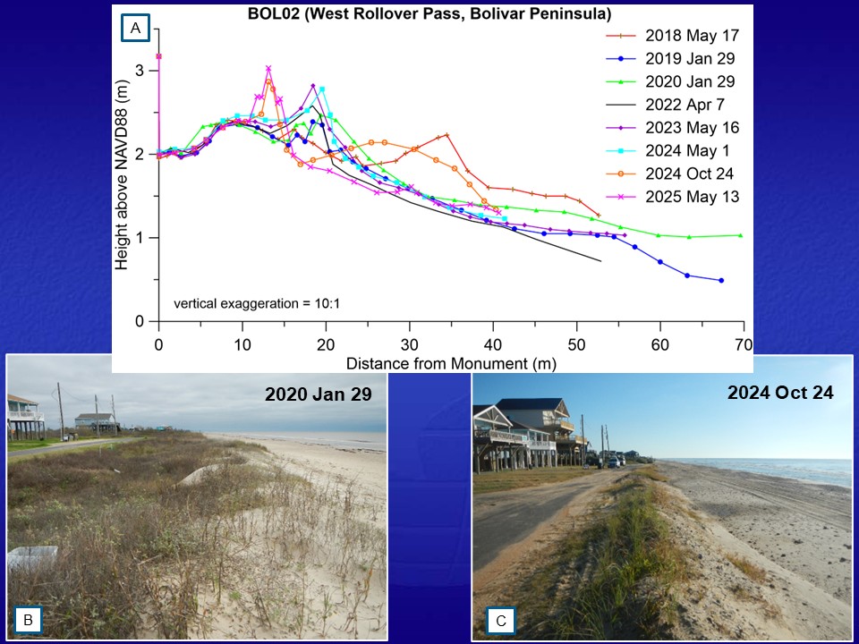
Figure 3. HIHS beach monitoring at BOL02 west of Rollover Pass. (A) Beach profiles showing the changes in topography at the site between May 2018 and May 2025. A small, vegetated dune was developing at this site between when the program began at High Island and the spring of 2024. During the October 2024 field trip, student collected data documented a narrow push-up dune had been created adjacent to Keith Avenue from sand that over washed the street during Hurricane Beryl (July 2024). The shape of the beach profile was significantly different from earlier in 2024 with a narrower beach but higher elevation berm. (B) Photograph looking east along the vegetation line and low foredune present during the field trip on January 29, 2020. (C) BOL02 photograph looking east along the newly created dune crest on October 24, 2024. Note the position of the dune crest in relation to the road in both photographs.
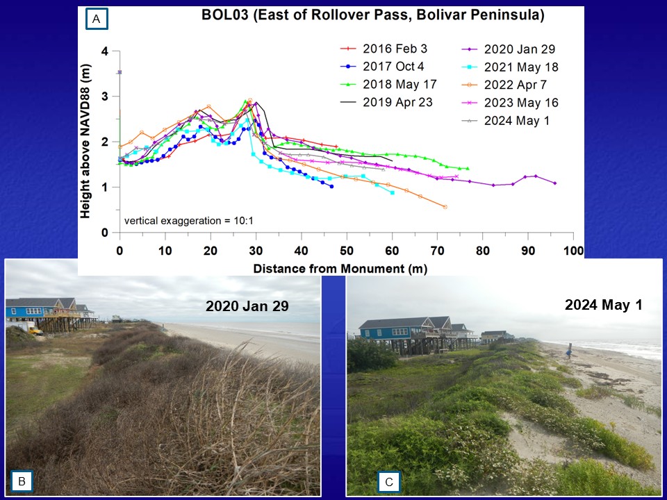
Figure 4. HIHS beach monitoring at BOL03 east of Rollover Pass. (A) Beach profiles showing the changes in topography at the site between February 2016 and May 2024. (B) Photograph looking east along the dune crest during the field trip on January 29, 2020. (C) BOL03 photograph looking east along the dune crest on May 1, 2024.
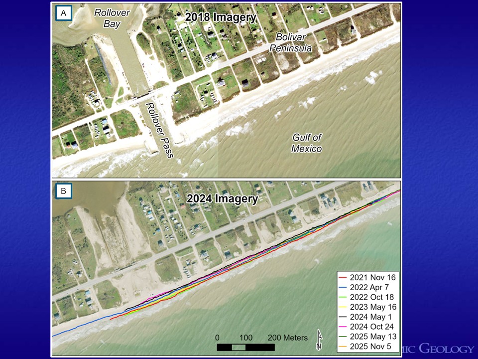
Figure 5. Rollover Pass was cut across Bolivar Peninsula in 1955 with the intention of improving water quality in Rollover Bay and Galveston East Bay. The opening of the pass caused significant erosion to the adjacent beaches and sand and sediment to be deposited in the Gulf Intracoastal Waterway (ICW). The U.S. Army Corps of Engineers was required to annually dredge and remove sediment from the ICW adjacent to Rollover Bay at significant cost. Due to these issues, the Texas Legislature authorized the General Land Office to close the pass. Construction began at the end of September 2019 and completed in spring 2020. (A) An aerial image of Rollover Pass taken in 2018 before closure of the pass. (B) An aerial image of Rollover Pass taken in 2024 after closure of the pass had been completed with GPS mapped shoreline positions from November 2021 through November 2025.


.png)

