
Photographs and Sketch
DIGITAL PHOTOGRAPHS
Photographs provide a qualitative record of the state of the beach. Taking them from the same vantage point each time will increase their value for interpreting beach changes. You will take five official photographs. A common mistake in taking these photographs is to include too much sky in the frame. You should have only about ¼ of the frame filled by the sky.
a) Walk 50 m to the side of the profile. From the wet/dry line, take a photo along the beach looking back toward the profile. Be sure to include some of the surf zone in the photo and the vegetation line if you can. Walk up to the foredune crest and take a photo looking back toward the profile.
b)Take the same photographs from the other side of the profile.
c)Take the fifth official photograph looking up the profile line from the waterline.
d)Go ahead and take additional photos of other interesting features on the beach and of your classmates. Note on the sketch page the photographs you take, and if necessary, explanatory notes of why you took them.
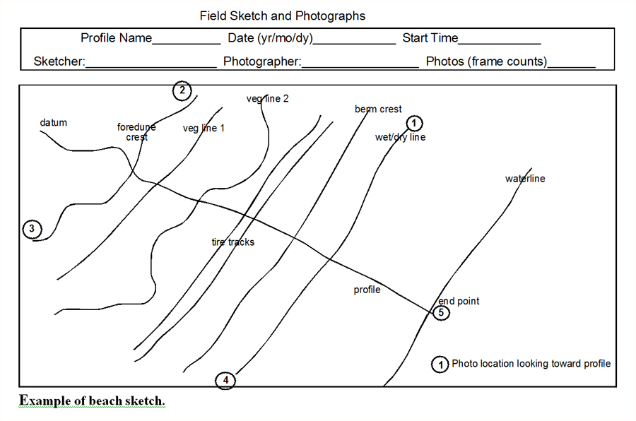
SKETCH
This is an optional exercise, but if you have the time to do it you should at least try. When you start drawing an object or landscape, you often notice things unnoticed before. A sketch of the beach will also help you interpret the quantitative data and photographs you collect. It need not be a work of art to be useful, as you can see in the example on the following page.
a) Walk 50 m from the profile to the right of the profile as you face seaward. Your vantage point for the drawing will be from above the beach and over the water. Because, of course, you cannot go to this point, you will have to imagine yourself looking down on the beach from that point while you draw.
b) On the data form with the grid, draw the foredune crest line or vegetation line along the left side of the paper and sloping up and to the right. If there are breaks in the foredune, such as blowouts, washover fans, or walkways, include them in your drawing.
c) Next draw the profile line perpendicular to the foredune line. Label the starting point and the ending point at the waterline. This profile line should show the shape (topography) of the beach with the berm tops, berm crests, and beach faces evident. The distances between these features should be proportional.
d) Now draw lines along the beach that represent the vegetation line, scarps, berm crests, cusps, and wet/dry line.
e) Fill in the drawing with observations of such things as deposits of shells, debris, or any other items or beach features. This is also a good place to document human alteration of the beach, such as dune fencing, planting of dune vegetation, or bulldozing of the beach.
f) Note on the sketch where photos were taken from. Look at example below.


.png)

