Vadose Zone and Soil Studies

Texas Soil Observation Network (TxSON)
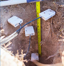
Texas Soil Moisture Observation Network (TxSON) is an intensively-monitored 36 km grid cell (1300 km2) located near Fredericksburg, Texas, along the Pedernales River and within the middle reaches of the lower Colorado River. The network consists of over 40 monitoring stations that measure in situ soil moisture and precipitation, mission and its Calibration and Validation Program. Using a nested design (>7 stations per cell), TxSON will replicate soil moisture at 3, 9 and 36 km satellite pixels in support of NASA’s Soil Moisture Active/Passive (SMAP) Cal/Val Program.

Studying Soil Carbon Dynamics in Permafrost Soils: North Slope, Alaska
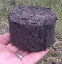
The BEG, in collaboration with researchers from the Department of Geological Sciences at the Jackson School, DOE’s Argonne National Laboratories, and NASA’s Jet Propulsion Laboratory are generating a high-resolution data set of SOC stocks and using this information to predict mobility of carbon from soils within ice-wedge polygons to wetlands and thermokarst lakes in low-gradient watersheds. The research is being funded by NASA, the Jackson School, and Great Bear Petroleum Holdings LLC, an operator on the North Slope of Alaska, and BEG’s partner in several lidar field campaigns The field site is located 50 km south of Deadhorse, Alaska, within wetland tundra that contains extensive ice wedge polygon terrain.

Improving Irrigation Water Use Estimates with Remote Sensing Technologies: An initial feasibility study for Texas
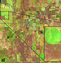
Accurate estimates of crop evapotranspiration (ET) are needed annually to determine irrigated water use per county and to feed into irrigation demand estimates state-wide. Remote sensing has the potential to improve the accuracy of crop ET (water out) and precipitation (water in) by increasing the spatial and temporal resolution state-wide.Our goal is to assess the feasibility of the current state-of-the-science remote sensing approaches to quantify crop ET across the climatically and agriculturally diverse landscape of Texas

Soil Characterization and Diffuse Recharge at Camp Bullis, Texas
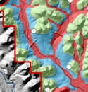
This pilot project will characterize the physical properties of soil at 23 existing monitoring locations, develop a 1-D vadose zone model for each location and benchmark the results to available time series data of in situ soil moisture at Camp Bullis. This project is aimed to collect preliminary soil physical and hydraulic data at existing monitoring locations on Camp Bullis. The results will help inform a recharge map that can guide further efforts for larger-scale ET mapping over the Edwards Aquifer Zone. This approach will focus on the controls of deep vadose zone recharge, namely soil water storage and percolation of precipitation below the root zone. Soil moisture data from existing stations at Camp Bullis
Completed Studies
Ecohydrology Studies (see all)
Ecological controls on water cycle response to climate variability
Impact of land use and land cover change on groundwater recharge and quality in the southwestern U.S.
Evaluation of evapotranspirative covers for waste containment in arid and semiarid regions in the southwestern U.S.A.
Groundwater Recharge (see all)
Global Synthesis of Groundwater Recharge in Semiarid and Arid Regions [PDF]
Assessing Controls on Diffuse Groundwater Recharge Using Unsaturated Flow Modeling
Choosing Appropriate Techniques for Quantifying Groundwater Recharge
Climate Variability and Climate Change Studies (see all)
Impact of ENSO on Groundwater Recharge in the Southwestern U.S.
Variations in Flow and Transport in Thick Desert Vadose Zones in Response to Paleoclimatic Forcing (0–90 kyr): Field Measurements, Modeling, and Uncertainties
Focused and Preferential Flow in Unsaturated Media (see all)
Focused Recharge Beneath Ephemeral Lakes (Playas) in the Southern High Plains, Texas
Focused Flow in Fissured Sediments in the Chihuahuan Desert
Groundwater Arsenic Contamination (see all)
Arsenic Contamination in Groundwater
Engineered Covers for Waste Containment (see all)
Monitoring
Modeling