
Groundwater Recharge
Global Synthesis of Groundwater Recharge in Semiarid and Arid Regions
Bridget Scanlon, Principal Investigator (March 2006)
Global synthesis of the findings from ~140 recharge study areas in semiarid and arid regions provides important information on recharge rates, controls, and processes, which are critical for sustainable water development. Water resource evaluation, dryland salinity assessment (Australia), and radioactive waste disposal (U.S.) are among the primary goals of many of these recharge studies. The chloride mass balance technique is widely used to estimate recharge. Average recharge rates estimated over large areas (40–374,000 km2) range from 0.2 to 35 mm/yr, representing 0.1 to 5% of long-term average annual precipitation. Extreme local variability in recharge, with rates up to ~720 m/yr, results from focused recharge beneath ephemeral streams and lakes and preferential flow mostly in fractured systems. System response to climate variability and land use/land cover (LU/LC) changes is archived in unsaturated zone tracer profiles and in groundwater level fluctuations. Interannual climate variability related to El Niño Southern Oscillation (ENSO) results in up to three times higher recharge in regions within the SW U.S. during periods of frequent El Niños (1977 - 1998) relative to periods dominated by La Niñas (1941-1957). Enhanced recharge related to ENSO is also documented in Argentina. Climate variability at decadal to century scales recorded in chloride profiles in Africa results in recharge rates of 30 mm/yr during the Sahel drought (1970–1986) to 150 mm/yr during nondrought periods. Variations in climate at millennial scales in the SW U.S. changed systems from recharge during the Pleistocene glacial period (=10,000 yr ago) to discharge during the Holocene semiarid period. LU/LC changes such as deforestation in Australia increased recharge up to about two orders of magnitude. Changes from natural grassland and shrublands to dryland (rain-fed) agriculture altered systems from discharge (evapotranspiration, ET) to recharge in the SW U.S. The impact of land use change was much greater than climate variability in Niger (Africa), where replacement of savanna by crops increased recharge by about an order of magnitude even during severe droughts. Sensitivity of recharge to LU/LC changes suggests that recharge may be controlled through management of land use. In irrigated areas, recharge varies from 10 to 485 mm/yr, representing 1 to 25% of irrigation + precipitation. However, irrigation pumpage in groundwater-fed irrigated areas greatly exceeds recharge rates, resulting in groundwater mining. Increased recharge related to cultivation has mobilized salts that accumulated in the unsaturated zone over millennia, resulting in widespread groundwater and surface water contamination, particularly in Australia. The synthesis of recharge rates provided in this study contains valuable information for developing sustainable groundwater resource programs within the context of climate variability and LU/LC change.
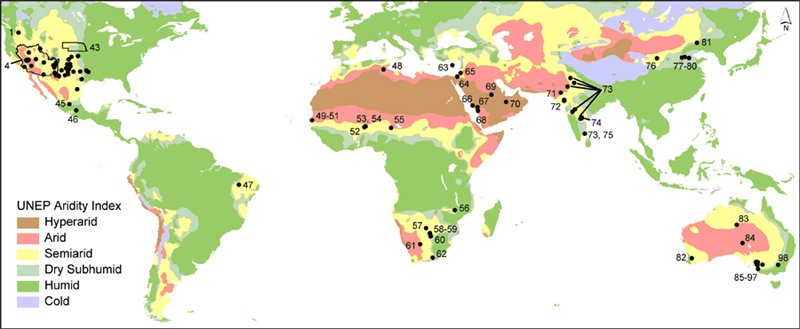
Global distribution of climatic zones (UNESCO 1979). Information on recharge studies is in Table 1. Location ID's for the SW U.S. were omitted owing to the high density of study locations.
Assessing Controls on Diffuse Groundwater Recharge Using Unsaturated Flow Modeling
Bridget Scanlon, Principal Investigator (March 2006)
Understanding climate, vegetation, and soil controls on recharge is essential for estimating potential impacts of climate variability and land use/land cover change on recharge. Recharge controls were evaluated by simulating drainage in 5-m-thick profiles using a 1-D unsaturated flow code (UNSAT-H), climate data, and vegetation and soil coverages from online sources. Vegetation parameters were obtained from the literature. Soil hydraulic properties were estimated from STATSGO/SSURGO soils data using pedotransfer functions. Long-term (1961–1990) simulations were conducted for 13 regions (county near meteorological station) that represent arid to humid climates and different vegetation (shrubs, grasses, forests, crops) and soil types, using data for Texas, U.S.A. Areally averaged recharge rates are most appropriate for water resources; therefore, Geographic Information Systems (GIS) was used to determine the spatial weighting of recharge rates for the combination of vegetation and soils found in each of the 13 regions. Simulated 30-yr average annual recharge in bare sand is high (51 mm/yr, arid to 709 mm/yr, humid) and represents 23 to 60% of mean annual precipitation (MAP) in arid to humid regions, respectively. Adding vegetation to bare sand had a similar effect on recharge as soil textural variability; vegetated sand reduced recharge by factors ranging from 2 to 30 (humid-arid), and soil textural variability reduced recharge by factors ranging from 2 to 11.
Vegetation and soil textural variability both resulted in high local variability in recharge within each region; however, spatially weighted, long-term average recharge rates were much less variable and were positively correlated with MAP (r2 =0.85, vegetated sand; r2 = 0.62, variably textured soils). The most realistic simulations included vegetation and variably textured soils, which resulted in a range of recharge rates from 0.2 to 118 mm/yr (0.1–10% of MAP). Mean annual precipitation explains 80% of the variation in recharge and can be used to map recharge.
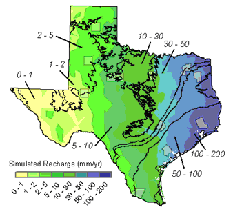
Predicted recharge using the relationship between precipitation and simulated recharge for vegetated, texturally variable soils.
Choosing Appropriate Techniques for Quantifying Groundwater Recharge
Bridget Scanlon, Principal Investigator (March 2006)
A variety of techniques are available to quantify recharge; however, choosing appropriate techniques is often difficult. Important considerations in choosing a technique include space/time scales, range, and reliability of recharge estimates based on different techniques; other factors may limit the application of particular techniques. The goal of the recharge study is important because it may dictate the required space/time scales of the recharge estimates. Typical study goals include water-resource evaluation, which requires information on recharge over large spatial scales and on decadal time scales, and evaluation of aquifer vulnerability to contamination, which requires detailed information on spatial variability and preferential flow. The range of recharge rates that can be estimated using different approaches should be matched to expected recharge rates at a site. The reliability of recharge estimates using different techniques is variable. Techniques based on surface-water and unsaturated-zone data provide estimates of potential recharge, whereas those based on groundwater data generally provide estimates of actual recharge. Uncertainties in each approach to estimating recharge underscore the need for application of multiple techniques to increase reliability of recharge estimates.
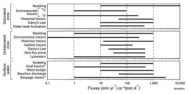
Range of fluxes that can be estimated using various techniques.

