
Soil Characterization and Diffuse Recharge at Camp Bullis, Texas
Program Overview
This pilot project will characterize the physical properties of soil at 23 existing monitoring locations, develop a 1-D vadose zone model for each location and benchmark the results to available time series data of in situ soil moisture at Camp Bullis.
Project Summary
Conduit flow in karst systems is thought to drive recharge to carbonate aquifers such as the Trinity and Edwards, even though dissolution joints, cracks and caves are a relatively small percentage of the landscape and hydrologically disconnected to groundwater when stream flow ceases. Diffuse recharge through matrix pore spaces, and micro-joints or fractures in bedrock is likely ubiquitous, but less discernible and highly heterogeneous. Variability in precipitation, soil water (or vadose zone) storage capacity and root-water uptake increases the complexity, making quantification of diffuse recharge challenging. This study will generate unsaturated hydraulic properties of surface and subsurface soils for input into a vadose zone model of Camp Bullis.
This pilot project is aimed to collect preliminary soil physical and hydraulic data at existing monitoring locations on Camp Bullis. The results will help inform a recharge map that can guide further efforts for larger-scale ET mapping over the Edwards Aquifer Zone. This approach will focus on the controls of deep vadose zone recharge, namely soil water storage and percolation of precipitation below the root zone. Soil moisture data from existing stations at Camp Bullis (Fig. 1) and targeted on-ground characterization of soil hydraulic properties will serve to benchmark and parameterize a 1-D model (HYDRUS), and act as a calibration check to HSPF, a different code used by Edwards Aquifer Authority for regional recharge modeling. Results from this pilot study will also be used to calibrate soil moisture data collected form 13 weather stations operated by the EAA throughout the Recharge Zone and Drainage Area of the Edwards Aquifer, which will be used as input data for future recharge models
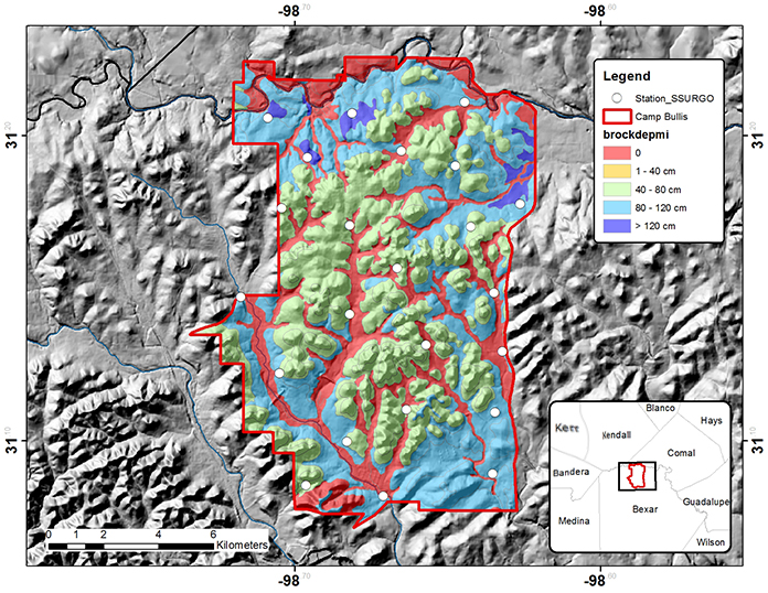
Figure 1. Depth to bedrock (cm) estimated from the NRCS SSURGO map for Camp Bullis monitoring locations.

