
Hydrogen (H2) has the potential to be a clean fuel alternative to replace hydrocarbons in a low-carbon economy. Salt caverns are excellent options for storing H2 on a large scale because they have a large storage capacity and flexible operation with large injection and withdrawal rates.
This iterative map shows the location of 569 salt domes located along the U.S. Gulf Coast.
In addition, we performed an analysis using our GeoH2 App (V2.0) to estimate H2 storage capacities for 98 salt domes along the Gulf Coast of the U.S. that don’t contain any man-made salt caverns. This analysis contains (see layers on GIS map)
- Distribution of number of domes (98)
- Number of caverns for a base scenario as described by the work of (Ruiz Maraggi and Moscardelli, accepted)
- H2 working gas potential
- Energy storage gas potential
- Heat map based on total energy [GWh]
This iterative map also allows to display relevant information linked to colocation of surface and subsurface resources including:
- H2 generation potential from both solar and wind (renewable energy)
- Location of refineries, CO2, and H2 pipelines
- Other cultural data
If you have questions, please contact:
Dr. Leopoldo Ruiz Maraggi (leo.ruiz@beg.utexas.edu) or Dr. Lorena Moscardelli (lorena.Moscardelli@beg.utexas.edu)
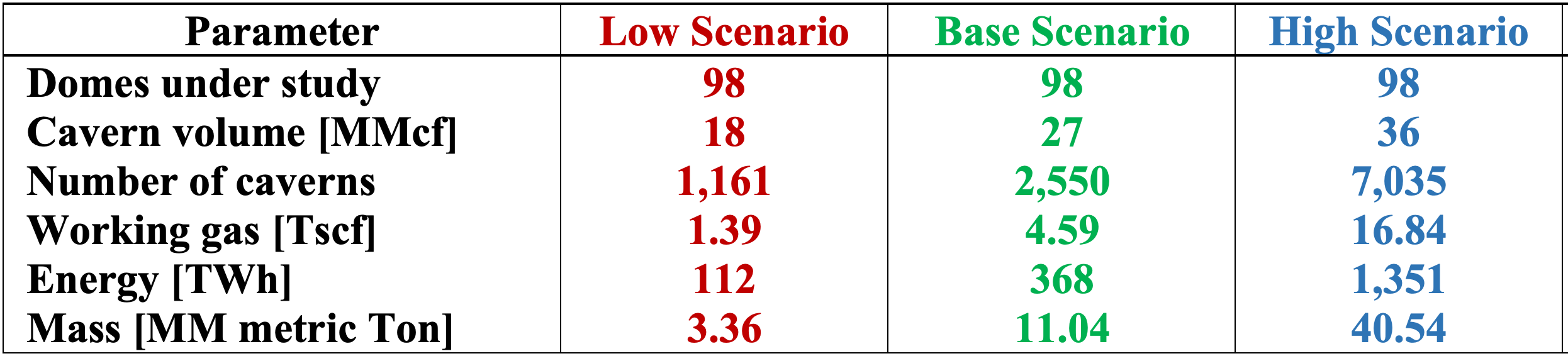
Results of hydrogen storage capacity calculations for 98 onshore salt domes along the Gulf Coast (with no reported man-made salt caverns)

