Powderhorn Ranch Geoenvironmental Atlas
Shoreline Types, Retreat Vulnerability, and Historical Movement
Shorelines are the dynamic boundary between land and water. Bay shorelines on the middle Texas coast have been grouped into 11 types that are distinguished by a combination of elevation, slope, depositional environment, material and consolidation level, and vegetation or habitat (fig. S1; Paine and others, 2016). From highest to lowest elevation, these types are: high and low bluff, sandy slope, fan delta, beach, spit, tidal pass, flood-tidal delta marsh or tidal flat, deltaic marsh, back-barrier marsh or tidal flat, and bay-margin marsh or tidal flat. Together, these shoreline types extend for about 1,065 km among the middle Texas bay systems.
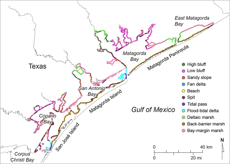
Figure S1. Distribution of principal shoreline types in the Copano, San Antonio, and Matagorda Bay systems (Paine and others, 2016)
Powderhorn Ranch has more than 20 km of bay or lake shoreline, including 8.4 km along Matagorda Bay and about 12 km along the southeastern shore of Powderhorn Lake. Common shoreline types at Powderhorn Ranch are sandy slopes, spits and beaches, and bay-margin marshes or tidal flats (fig. S2). Each of these shoreline types differs in material composition, elevation, slope, degree of consolidation, and vegetation cover and responds differently to the major causes of shoreline retreat and land loss, including non-storm wave action, storm surge and storm wave action, and relative sea-level rise (figs. S3 to S5). Most of the shoreline along Matagorda Bay and Powderhorn Ranch remains in its natural state. Only near the ranch house has a bulkhead and flanking riprap been emplaced (fig. S6).
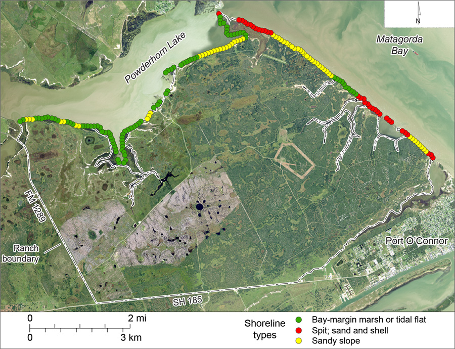
Figure S2. Shoreline types on Powderhorn Ranch along Matagorda Bay and Powderhorn Lake
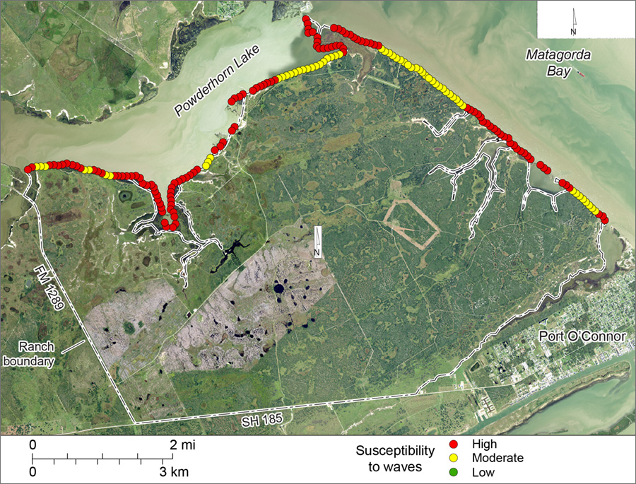
Figure S3. Shoreline susceptibility to non-storm wave activity on Powderhorn Ranch along Matagorda Bay and Powderhorn Lake.
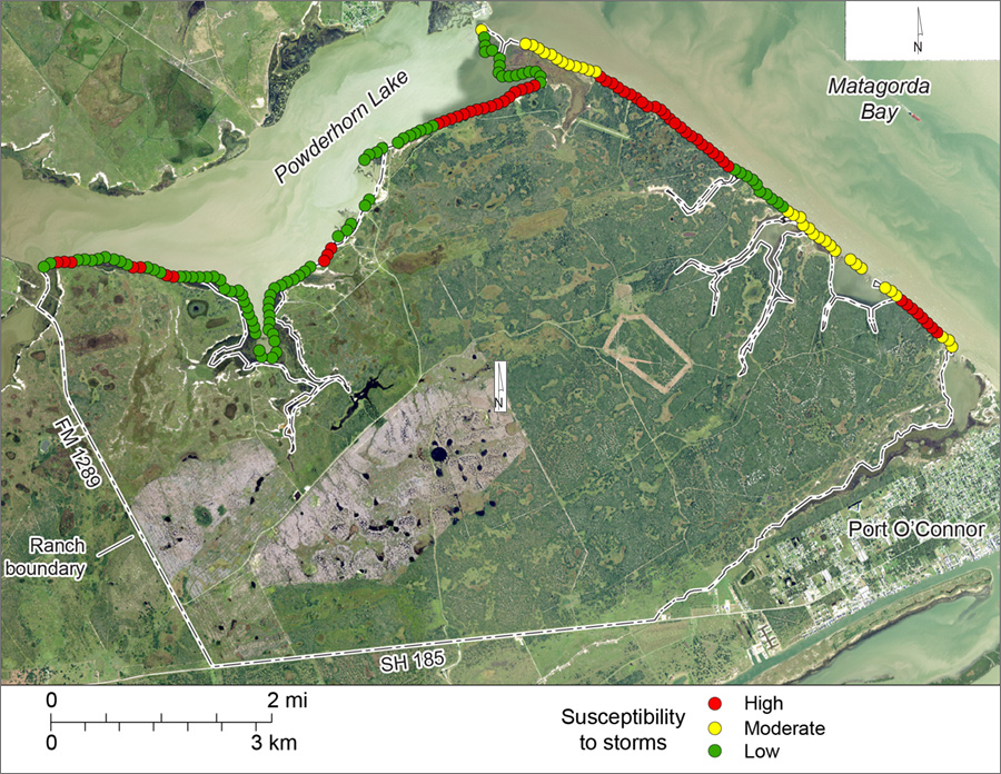
Figure S4. Shoreline susceptibility to storm surge and storm waves on Powderhorn Ranch along Matagorda Bay and Powderhorn Lake.
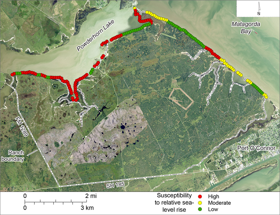
Figure S5. Shoreline susceptibility to relative sea-level rise on Powderhorn Ranch along Matagorda Bay and Powderhorn Lake.
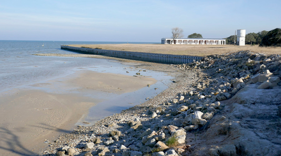
Figure S6. Bulkhead and riprap along the Matagorda Bay shoreline at the ranch house.
Sandy Slopes
Sandy or clayey sand slopes occur along about a third of the Powderhorn Ranch shoreline and are located where low to moderate sandy Ingleside bluffs intersect the shoreline along Matagorda Bay and along Powderhorn Lake near where it joins Matagorda Bay. Sandy slopes are composed of unconsolidated to semiconsolidated sand to muddy sand that can be partly stabilized by upland grasses and shrubs (fig. S7). Elevations on the slopes landward of the shoreline range from 1 to 3 m above sea level. Some of the sandy slopes are fronted by narrow sandy beaches or marshes. Sandy slopes are highly susceptible to shoreline retreat caused by storm surge and storm waves (fig. S4) and moderately susceptible to erosion from non-storm wave activity (fig. S3), but are relatively insensitive to short-term relative sea-level rise (fig. S5) given their higher elevation.
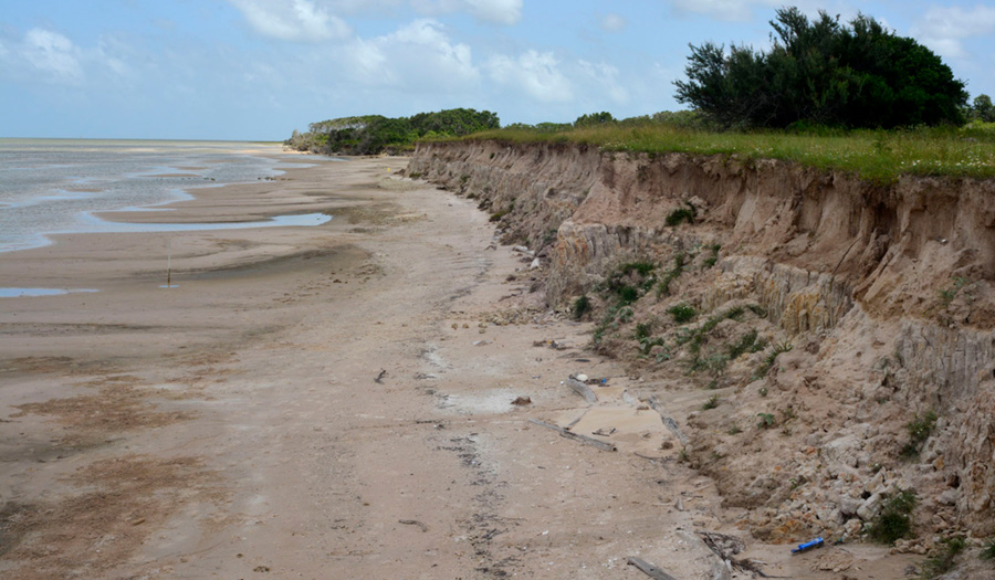
Figure S7. Sandy slope along the Matagorda Bay shoreline of Powderhorn Ranch.
Spits
Spits are low, elongate, and unconsolidated sandy and shelly beaches that form along eroding bay shorelines by longshore drift and lateral migration (fig. S8). At Powderhorn Ranch, they comprise about 18 percent of the total shoreline length and are found across small embayments where topographic swales and drainages reach Matagorda Bay and where Matagorda Bay intersects Powderhorn Lake (fig. S2). Because of their low elevation and unconsolidated state, they are highly susceptible to erosion from non-storm wave action and are moderately susceptible to retreat caused by relative sea-level rise and storm-related surge and waves.
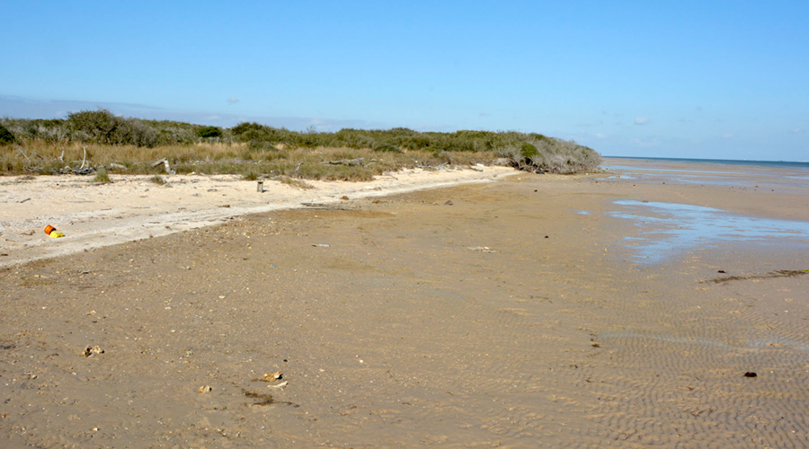
Figure S8. Sandy and shelly spit along the Matagorda Bay shoreline of Powderhorn Ranch.
Bay-margin Marshes or Tidal Flats
Bay-margin marshes and tidal flats are the most common shoreline type at Powderhorn Ranch, constituting half of the total shoreline length (fig. S2). They are most common in the lower-energy environment along Powderhorn Lake. Bay-margin marshes and tidal flats have low elevation, minimal slope, muddy sand or sandy mud substrate, and dominant marsh vegetation with interspersed tidal flats (fig. S9). These shorelines are highly susceptible to erosion by non-storm waves and to land loss by submergence related to relative sea level rise. They have a low susceptibility to erosion related to storm surge and storm waves because they are inundated before storm passage.
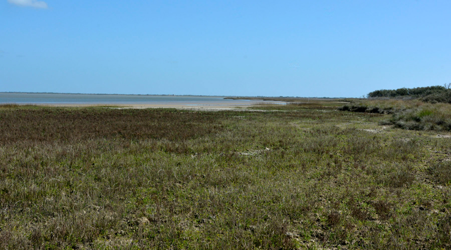
Figure S9. Bay-margin marsh and tidal flat along the Powderhorn Lake shoreline of Powderhorn Ranch.
Historical Shoreline Movement Two major shoreline change studies that include the Powderhorn Ranch shorelines have been conducted by the BEG. The first study used shoreline positions from 1800s topographic charts and from aerial photographs taken between the 1930s and 1950s to examine historical shoreline change rates for the Matagorda Bay area (McGowen and Brewton, 1975). More recently, BEG researchers determined Matagorda Bay shoreline positions from a 2015 airborne lidar survey and analyzed historical shoreline change rates from the 1930s to 2015 (Paine and others, 2016).
In the recent study, shoreline movement at Powderhorn Ranch was determined at 180 measurement points spaced at 100-m intervals along the Matagorda Bay and Powderhorn Lake shoreline (fig. S10). Overall, net shoreline movement rates range from retreat at 3.6 m/yr to advance at 1.8 m/yr, averaging retreat at 0.8 m/yr. Translated to land area loss, these data suggest that Powderhorn Ranch land loss averages 1.6 ha/yr for a total estimated land loss of 136 ha from 1930 to 2015.
Net retreat rates are higher along Matagorda Bay than they are along Powderhorn Lake. The Matagorda Bay shoreline has greater exposure to non-storm wave activity during frontal passage and storm surge and storm wave effects during frequent tropical cyclones. Net shoreline movement rates averaged 1.5 m/yr of retreat; the shoreline retreated at all but one of the 73 measurement points on Matagorda Bay. Along Powderhorn Lake, net shoreline movement rates averaged 0.3 m/yr of retreat.
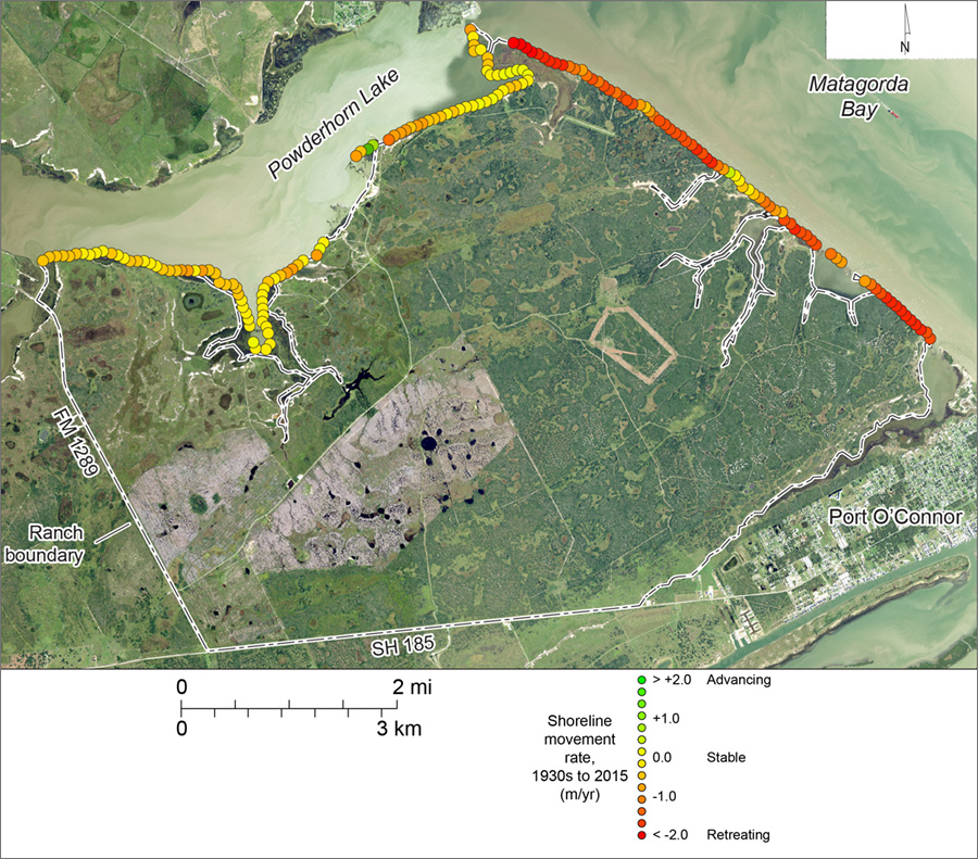
Figure S10. Net shoreline movement rates between the 1930s and 2015 along the Matagorda Bay and Powderhorn Lake shorelines of Powderhorn Ranch. Data from Paine and others (2016).
References
McGowen, J. H., and Brewton, J. L., 1975, Historical Changes and Related Coastal Processes, Gulf and Mainland Shorelines, Matagorda Bay Area, Texas: The University of Texas at Austin, Bureau of Economic Geology, Special Report SR0003, 72 p.
Paine, J. G., Caudle, T., and Andrews, J. R., 2016, Shoreline movement in the Copano, San Antonio, and Matagorda Bay systems, central Texas coast, 1930s to 2010s: Bureau of Economic Geology, The University of Texas at Austin, Final Report prepared for General Land Office under contract no. 13-258-000-7485, 72 p.