
Geologic Wonders of Texas Glossary
Click on the thumbnails to see larger photos.
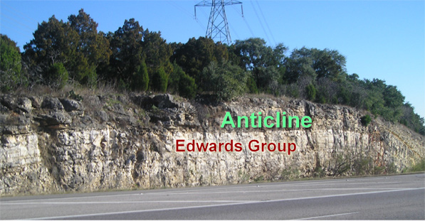
Anticline
Anticline
A fold of rock layers that convex upward. Oldest rocks located in the center of the anticline.
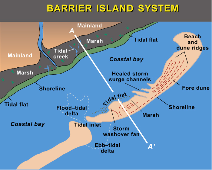
Barrier island system
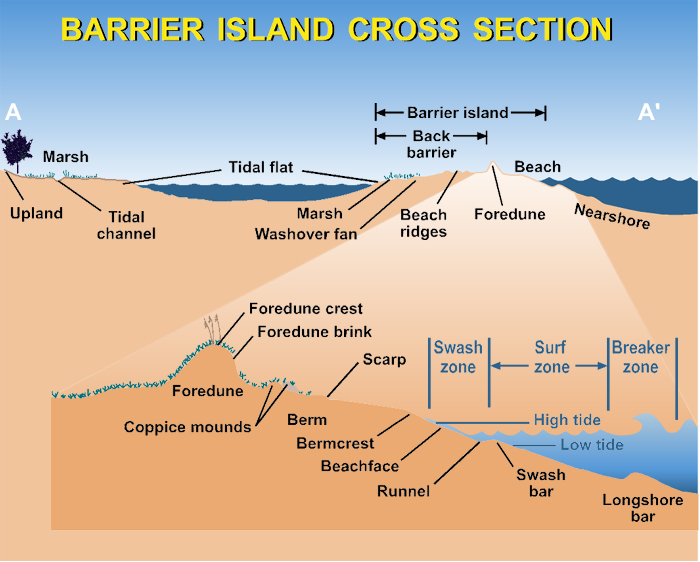
Barrier island cross-section view
Barrier Island
A barrier island is a narrow island of sand that lies parallel to a shoreline. Barrier islands buffer the mainland from storms and large waves formed in the ocean. The area behind a barrier island—commonly called a lagoon—has relatively low-energy, enabling the formation of important environments such as marshes, flats, seagrass beds, and oyster reefs that could not form under the constant crashing of large waves.
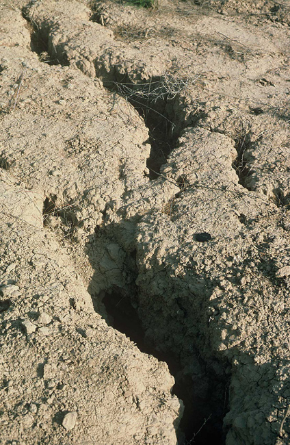
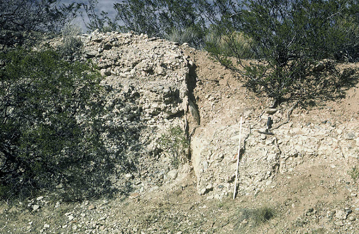
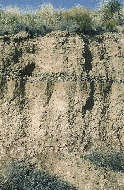
Caliche
Caliche
Most people who live in the drier parts of Texas are familiar with caliche. It's that white soil that you commonly see. In some places the white soil is soft, and other places it's almost as hard as rock. The soil is white because it's mostly calcium carbonate, the same mineral that makes up limestone, and scientists call these "calcic soils." Calcic soils form in desert areas where the rainfall is low. The rainwater is absorbed by the soils, but the soils are so dry that the moisture stays in the top few feet of the soils until it evaporates or is taken up by plant roots. The rainwater has minor amounts of calcium carbonate, either particles that have dissolved in the water or tiny dust particles, and the calcium carbonate is left behind in the soil when moisture is evaporated or used by plants. Over many years so much calcium carbonate is added to the soils that they turn white. Over thousands of years so much calcium carbonate is deposited that a rock-hard caliche is formed that may be several feet thick.
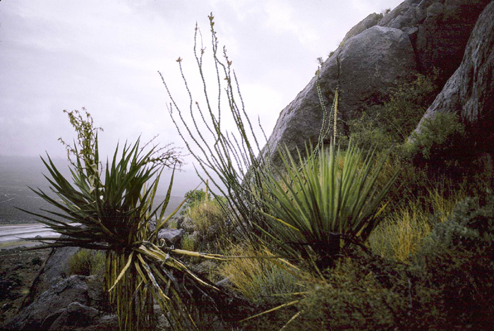
Chihuahuan Desert
Chihuahuan Desert
The Chihuahuan Desert lies mostly in Trans Pecos Texas and southern New Mexico in the United States, but it extends far into central Mexico. It has unique plant and animal communities. Most of the Chihuahuan Desert is more than 1 thousand feet in elevation, and it's pretty dry. Rainfall is generally less than about 12 inches per year, and evaporation always exceeds precipitation. It may be a desert, with hot summers and cool winters, but it has many interesting animals and plants as well, and some pretty flowers. [Website]
Coastal Plain
A flat, low-lying geographical region near an ocean. The Texas Coastal Plain extends north and south from Dallas to San Antonio to the Texas Gulf Coast.
Dolostone (or dolomite)
A sedimentary rock composed primarily of dolomite, a mineral made up of calcium, magnesium, carbon, and oxygen.
Escarpment
A continuous line of cliffs or steep slopes facing in one general direction which is caused by faults or erosion.
Fault
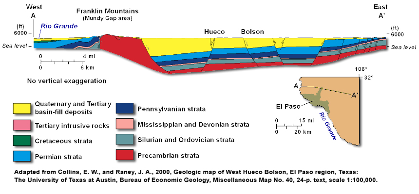
Franklin cross-section diagram
Western tilt of the Franklin Mountains
Faults
There are places where the Earth breaks and rocks on one side slide past the rocks on the other side. The break itself is called a "fault." Thousands of feet of relative movement ("displacement") occurs along some of these faults. The movement did not happen all at one time, though. It occurred during events that were mostly quite small, although some were several tens of feet in a single event. These movement events are what produce earthquakes. Most earthquakes are so small we can't feel them, but large earthquakes, which are uncommon, can cause lots of damage.
Franklin Mountains faults:
The main faults that formed the Franklin Mountains are in the foothills along the east and west sides of the range (see Franklins Cross Section diagram). These faults have thousands of feet of relative movement, and the Hueco Bolson has thousands of feet of basin-fill sediments. Along most of the range, the Franklin Mountains are tilted to the west. The west tilt suggests that the east side of the Franklins has moved up along the faults more than the west side.
Geologist
Geology/geologists
Geology, the study of the Earth, includes the study of rocks and minerals; Earth processes such as earthquakes, volcanoes, beaches, and rivers; and natural resources such as groundwater, oil and gas, geothermal issues, energy, metals, and many other things. The people who study the Earth are geologists. Geologists may study the Earth by making observations in the field or by collecting data from wells or by determining the physical properties of the Earth (geophysics) or the chemical properties (geochemistry). Geologists use computers to help interpret the data. The results help people find the natural resources that we need, help protect our environment, or help reduce the impacts of natural hazards like earthquakes and floods.
Arroyo
Gravel, sand, silt, and clay
Sediment, that loose "dirt" that you see along an arroyo or at the edge of the mountains and in the basins, can be interesting stuff. When geologists look at sediments, the first thing they notice is the size of the particles. Are the particles really fine grained, so fine that it is hard to see individual pieces, so fine that it does not feel gritty and is dusty? Then what they are looking at is probably mostly clay and silt. If it's a little coarser and gritty, and the tiny grains are easily seen, then it's probably sand. If it's coarser still, coarser than about 2 mm (0.08 inches), then it's gravel. The size of the grains tells geologists something about how the sediment was deposited. The clay deposits that are part of the basin sediments, for example, were deposited in lakes. Why? Because lakes are quiet water in which the fine clay particles can settle out to the bottom, and fast current and clays are carried away. We also see sand and gravel that were deposited in flash floods along the mountains or by rivers like the Rio Grande. Deposits of almost pure sand are also heaped up by the winds in sand dunes.
Limestone
Produced by sediments that included the shells of ancient marine creatures that were composed of calcite (calcium, carbon, and oxygen). Burial and compression of these sediments formed limestone formations. Limestone is the most common rock in Texas.
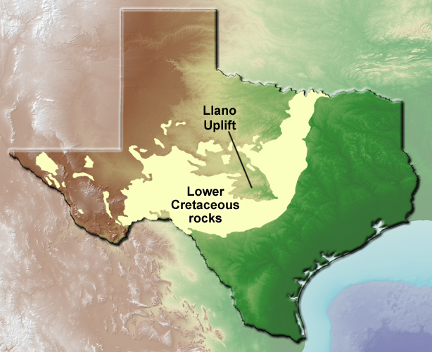
Llano Uplift and Cretaceous rocks
Llano Uplift
A roughly oval-shaped area in central Texas where Precambrian- and Paleozoic-aged rocks are structurally high and have been exposed by erosion of the Cretaceous rocks of the Edwards Plateau. These pre-Cretaceous rocks are present in the subsurface throughout much of Texas, but are primarily exposed in the Llano Uplift.
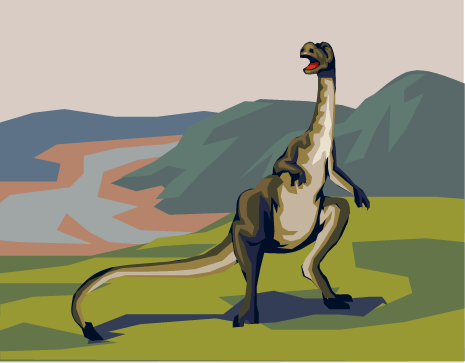
Artist's rendering of ornithopod
Ornithopod (suborder Ornithopoda)
Medium to large herbivorous (plant-eating) dinosaurs that mostly walked on two hind feet. They are one of the three major groups in the ornithischian (bird-hipped) dinosaurs. Iguanodon and crested, "duck-billed" Hadrosaur are well known examples of ornithopods. [More information]
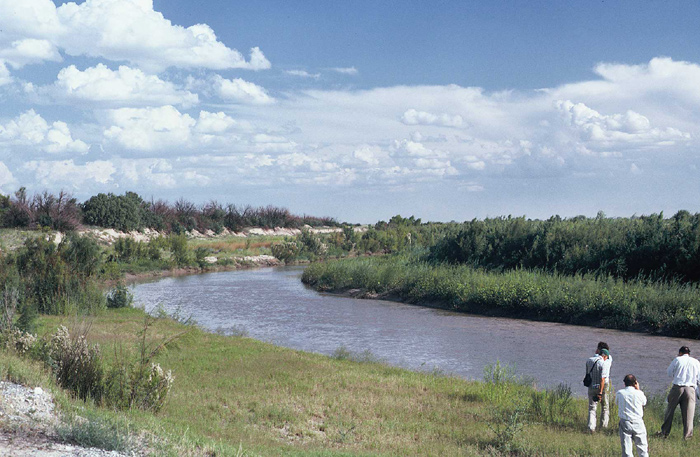
Rio Grande
Quitman Mountains
Rio Grande/Rio Bravo
The river that is the boundary between Texas and Mexico is the Rio Grande, although our friends in Mexico call it the Rio Bravo. The Rio Grande begins in Colorado, flows across New Mexico down the Rio Grande Rift, and then flows along the border between Texas and Mexico to the Gulf of Mexico near Brownsville. West of the Franklin Mountains it is in the Mesilla Bolson, but as it goes through El Paso it enters the Hueco Bolson.
A few million years ago the Rio Grande flowed down the Rio Grande Rift and ended in a large desert lake that extended into Mexico. About 2 million years ago the Rio Grande cut a channel to the southeast near the Quitman Mountains and developed its current drainage system, which leads to the Big Bend area and eventually the Gulf of Mexico. For much of its early history the Rio Grande flowed across the northern Franklin Mountains near Fillmore Pass to enter the Hueco Bolson.
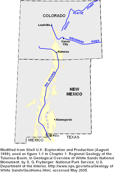
Rio Grande Rift
Rio Grande Rift
The geologic story of the Franklin Mountains and adjacent basins is about a violent Earth. This area is part of a large region of the Earth that has extended and been pulled apart. That extension broke the rocks along deep cracks (called faults), and huge blocks (measured in miles) slid down along the cracks to form basins. Other enormous blocks of the Earth moved up along the faults to form mountains. This region of extension continues from the El Paso area north into New Mexico and southern Colorado and is called the "Rio Grande Rift." El Paso, Socorro, and Albuquerque are all cities within the Rio Grande Rift. Another large region of extension is the Basin and Range province that covers most of Nevada and western Utah.
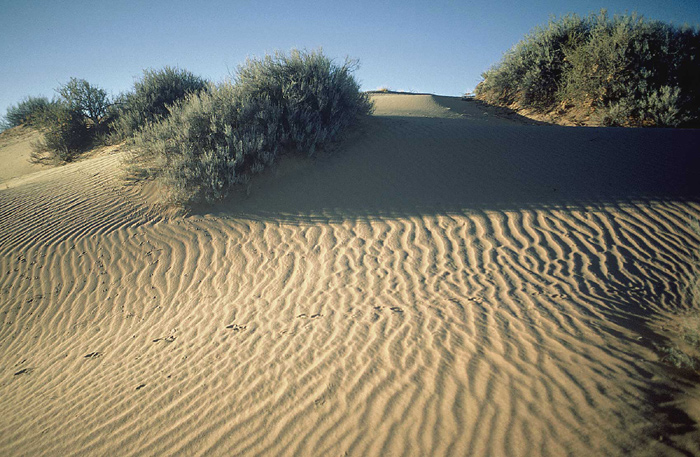
Sand dunes with ripple marks formed by wind
Sand dune
The desert basins commonly have windblown sand. You may see small deposits of sand around plants, boulders, telephone poles, or anything that slows down the wind. A "sand dune" is any pile of windblown sand, but some in the Hueco Bolson are pretty big piles of sand. One of the interesting things about windblown sand is that most of the sand grains are all about the same size. Most winds are not strong enough to carry larger grains like gravel, but smaller grains, like clay and silt, are carried far beyond where the wind drops the sand. Sand dunes often have interesting patterns, like ripple marks, formed by the wind, and on a windy day you can often see how the wind makes sand dunes.
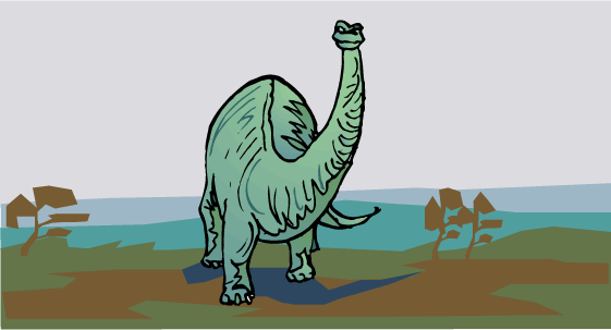
Artist's rendering of sauropod
Sauropod (suborder Sauropoda)
Very large herbivorous (plant-eating) dinosaur that lived during the Jurassic and Cretaceous Periods (about 200 to 65 million years ago). These animals are characterized by a small head on a long neck, a long tail and five toes on their feet. Apatosaurus (a.k.a. "Brontosaurus") and Diplodocus are well known example of sauropods. [More information]
Sedimentary rocks
Rock formed from the weathered products of preexisting rocks that have been transported by water, wind, or glaciers. Sedimentary rocks include various varieties of limestone and sandstone.
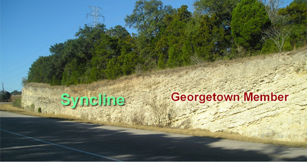
Syncline
Syncline
A fold of rock layers that is convex downwards. Youngest rocks located in the center of the syncline.
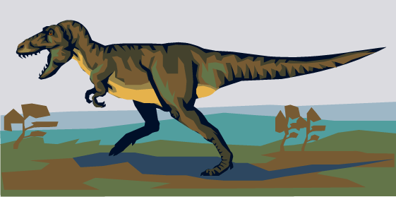
Artist's rendering of a theropod
Theropod (suborder Theropoda)
Large carnivorous saurischian (lizard-hipped) dinosaurs of the of the Jurassic and Cretaceous Periods (about 200 to 65 million years ago). They walked on their two back feet, and most had large jaws and short "arms." Tyrannosaurus rex is a well-known example of a theropod. [More information]

