Central Texas

What and Why
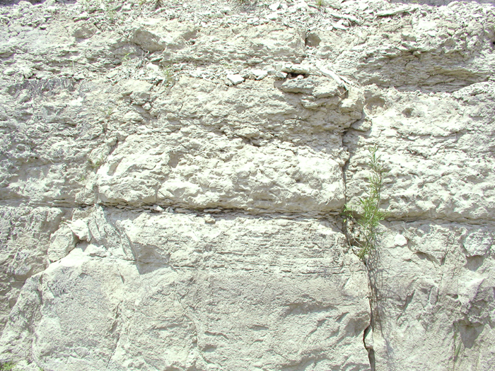
Central Texas limestone, click image to view larger.
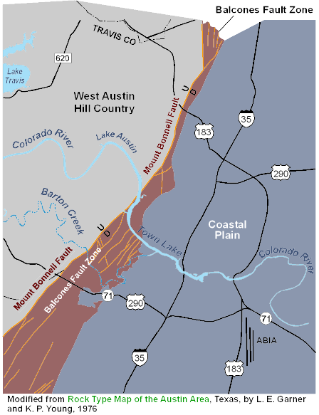
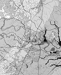
A map showing from east to west the Texas Coastal Plain, Balcones Fault Zone, and the West Austin Hill Country. Click to view larger.
What?
The west Austin Hill Country, also known as the Balcones Canyonlands, is composed of rugged topography, with flat-topped hills separated by steep canyons. The Austin Hill Country starts just west of the Balcones Escarpment.
Why?
Faulting occurred in Central Texas millions of years ago, when the coastal plains to the east bent downward while the more stable central Texas interior of the Llano Uplift remained relatively stable. The Balcones Escarpment and the west Austin Hill Country are the result of this fault episode.
The east side of Austin moved downward by as much as 700 feet. After millions of years of erosion, the soft sediments in the Hill Country area were eroded away, exposing the hard, Lower Cretaceous limestones and dolostones. This erosion created hills and steep canyons in the west Austin Hill Country.
Links and other neat stuff:
- Austin lidar VRML and flyover (see below)
- Geologic time scale (PDF)
- Collins, E. W., and Laubach, S. E., 1990, Faults and fractures in the Balcones Fault Zone, Austin Region, Central Texas: Austin Geological Society Guidebook 13, 34 p.
- Trippet, A. R., and Garner, L. E., 1976, Guide to points of geologic interest in Austin: The University of Texas at Austin, Bureau of Economic Geology, Guidebook 16, 38 p.
View a flyover of Austin from the Coastal Plain, to the Balcones Fault Zone, and the West Austin Hill Country. Requires player (such as Windows Media Player or RealPlayer) for .wmv format movie.
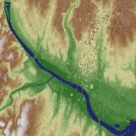
Click here to download an interactive model of Austin to view the Texas Coastal Plain, Balcones Fault Zone, and the West Austin Hill Country. You will need to have the capability of opening VRML (.wrl) files to view.
Where
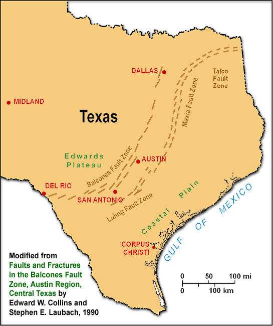
The Balcones Fault Zone extends from Dallas to the north and Del Rio to the southwest. The West Austin Hill Country is part of a larger geographical area called the Edwards Plateau.
Where is it?
The Balcones Escarpment was created by faulting that runs past the city of Waco, north of Austin, and past San Antonio, southwest of Austin.
How do I get there?
In Austin the escarpment generally parallels MoPac (Loop 1). To the west of MoPac, Austin becomes hilly, and east of MoPac, Austin is relatively flat. If you drive along Route 360 or RR 2222, you are driving in the west Austin Hill Country. Click here to explore the area on Google maps. (link goes to Mt. Bonnell)
Click images to view larger.
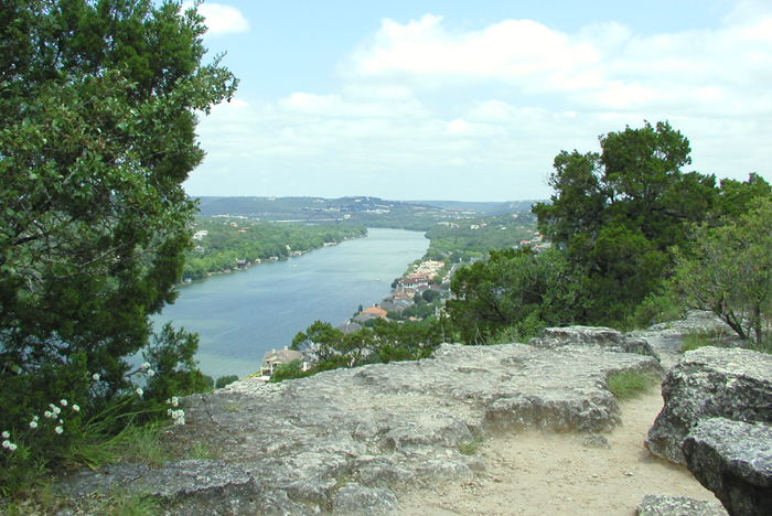
Photo from atop Mt. Bonnell, one of the most prominent geologic features in the Austin area with an elevation of 785 feet. The Texas Hill Country begins here and stretches to the west. Photo by Sylvia Jennette, UT BEG.
FAQ
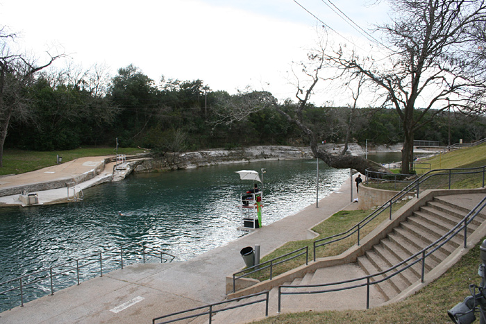
Barton Springs pool. Photograph by Hayley E. Loucks.
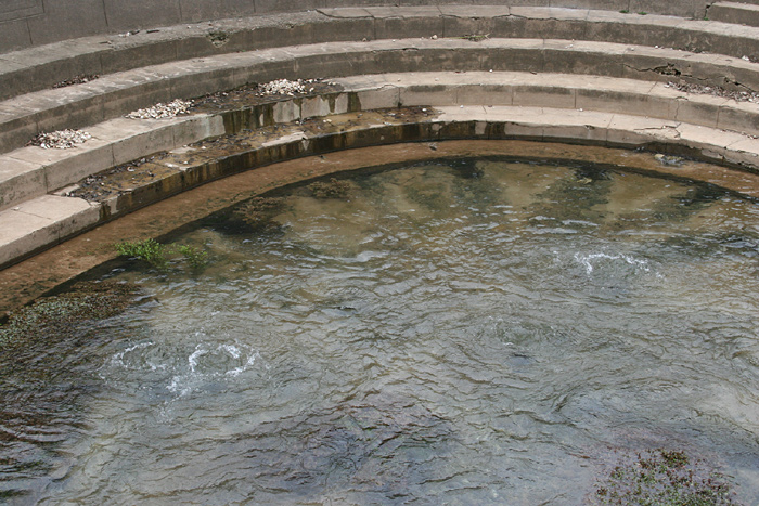
Water from the Edwards Aquifers percolates to the surface at Barton Springs pool. Photograph by Hayley E. Loucks.
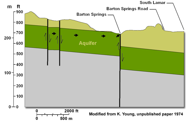
Water flows through the Edwards Limestone until it hits the big fault at Barton Springs. The groundwater flows up the fault and fills the swimming pool.

Pedernales floodwaters. Photo courtesy of Texas Parks and Wildlife Dept.
Frequently Asked Questions:
Q. How old is the faulting?
A. We don't know the exact age of Balcones faulting, but we are fairly sure that major movement along the fault occurred between 20 and 25 million years ago during the Miocene Period. See time scale, (PDF).
Q. How long did it last?
A. The faulting probably lasted several million of years, with approximately 700 to 1,000 feet of uplift occurring in numerous tiny steps.
Q. Did the faulting create earthquakes?
A. Probably many earthquakes rocked the Austin area, with movement occurring along the fault, much in the same way that active faults in California create earthquakes today. Visit the UT Institute for Geophysics website, and learn more about earthquakes.
Q. Can the Balcones fault still move and can it still create earthquakes?
A. The Balcones fault has not moved in recorded history, but this does not mean that it could not move again! Some think that the fault did move during the early Pleistocene, just over a million years ago. Also, two small earthquakes in the last 130 years (1893 and 1902) may have been caused by small movements along the Balcones fault.
Q. Are the rocks of different ages across the fault?
A. The rocks near the surface in the west Austin Hill Country are Lower Cretaceous, ranging from 100 to 112 million years in age. They are called the Glen Rose Formation and Edwards Group. The rocks east of the Balcones Escarpment are Upper Cretaceous rocks, ranging in age from 70 million to 100 million years. The Upper Cretaceous in the Austin area is composed of the Georgetown, Del Rio, Buda, and Eagle Ford Formations, as well as the younger Austin Chalk and Taylor Clay. See time scale, (PDF).
Q. How does the west Austin Hill Country affect Austin?
A. On the positive side, the Austin Hill Country creates beautiful home sites with magnificent views. On the negative side, the hill country creates some of the worst flash flooding in the United States. Because of high rainfall rates and rapid runoff in the hill country area, violent floods have hit Austin. Back in 1900, the first Tom Miller Dam was washed away during a great flood, and the lake behind the dam was drained. Also, in 1981 another great flood came out of the west Austin Hill Country and flooded the city. Water moved so fast that it piled cars one on top of the other.
The springs that supply water to Austin's popular Barton Springs swimming pool are controlled by faults. Rainwater in the Barton Creek watershed (a region draining into a body of water) sinks into the ground and becomes groundwater. This water flows through the Edwards Limestone until it hits the big fault at Barton Springs. The groundwater flows up the fault and fills the swimming pool. The average rate of flow from Barton Springs is approximately 53 million gallons per day!
Activities

A. Edwards and younger Georgetown limestones folded by movement along the fault. Beds of rock on the east side of the fault have moved downward by 10 feet relative to beds on the west side of the fault.
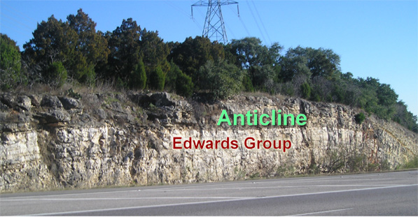
B. An example of an anticline in the Edwards Group at Loop 360 and MoPac
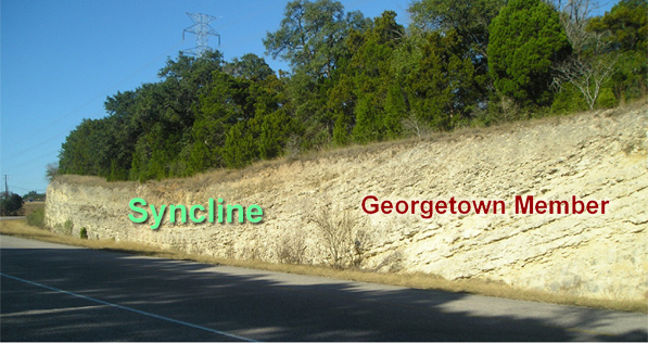
C. An example of a syncline in the Georgetown Member at Loop 360 and MoPac

D. A large road cut at the intersection of Loop 360 and Bee Caves Road (2244) has exposed a magnificent outcrop of Lower Cretaceous rock of the west Austin Hill Country.
Activities
Where can I see the effects of faulting?
The Balcones fault is not a single fault but a zone of faults that extend from the escarpment out to the east for approximately 2 to 5 miles (map). Within the zone of faulting, large sections of rocks are not only offset from each other, but they are also fractured (broken) and folded and can be seen in several areas in Austin.
At the intersection of Loop 360 and MoPac an outcrop of Edwards and younger Georgetown limestones (A, B, C) that shows folding caused by movement along the fault. An anticline (beds curve upward) is to the left of the fault, and a syncline (beds curve downward) is to the right of the fault.
Look at the rocks
Take a look at the rocks at Loop 360 and Bee Caves Road (RR 2244) (D), where a large road cut has exposed a magnificent outcrop of Lower Cretaceous rock. These rocks are flat-lying because they were not in the major zone of faulting. The darker colored rocks at the bottom of the outcrop are the Glen Rose Formation, and the lighter color rocks above are the Edwards Formation.
These rocks are evidence that Austin was periodically submerged under a shallow sea during the Early Cretaceous Period 135 to 102 million years ago. During this time, hundreds of feet of sediment that eventually formed into limestone was deposited in this area. This outcrop exposes approximately 170 feet of rock and represents 1.75 to 3 million years of time. According to these calculations, 1 foot of limestone would have taken between 10,000 and 20,000 years to form.
Download this activity page as a printer-friendly PDF.
Photographs by Hayley E. Loucks.
Rock and Soil Facts
Rock, sediment, and soil facts
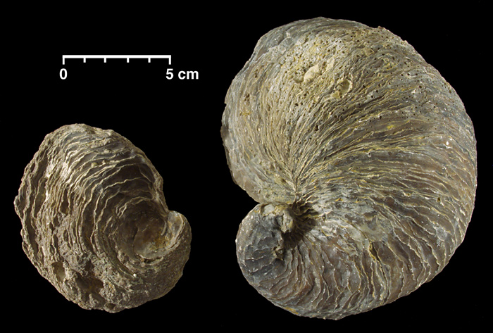
Fossilized remains of an ancient oyster named Exogyra ponderosa can be found in Austin Group rocks. This provides further evidence that Austin was once covered by a shallow ocean during Cretaceous time more than 100 million years ago.
Austin soils map (PDF).
Rocks and dirt
Rocks in the west Austin hill country are Early Cretaceous in age and consist of the Glen Rose and Edwards Formations. See time scale, (PDF). They are composed of limestone and dolomite that were deposited in shallow, warm-water seas, which covered much of Texas during this time in Earth's history. Fossils consisting of animals and plants that lived in the seas are abundant in some rock layers. Some of the rocks even have dinosaur footprints!
Soils
Soils east of the Balcones Escarpment are deep, well-developed, and produce excellent farmland. West of the escarpment, soils are thin and rocky and are used as ranchland.
For detailed information on local soils see the "Soil Map" in Garner, L. E., and Young, K. P., 1976, Environmental geology of the Austin area: an aid to urban planning: The University of Texas at Austin, Bureau of Economic Geology Report of Investigations No. 86. Click here to order this as a digital publication (PDF) or here to order a printed version.
Geodetective
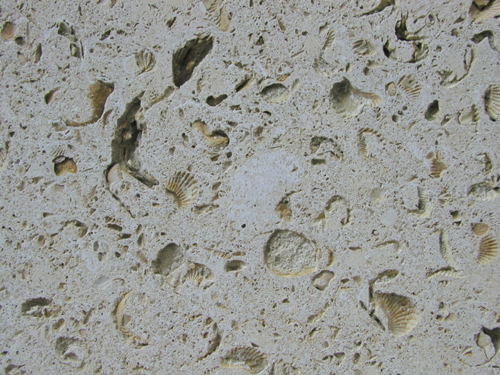
Limestone from the Lower Cretaceous Walnut Formation showing shell fragments and imprints of bivalves (clams) and gastropods (snails).
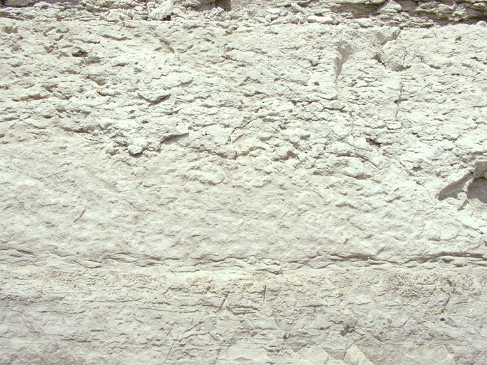
Limestone showing intense burrowing by an ancient shrimp-like creature called Thalassinoides. These kinds of fossils are called trace fossils.
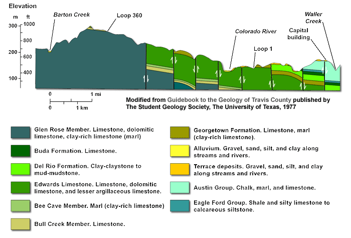
A cross section of Austin through the Balcones Fault Zone that shows where major faults are located.
Geodetective
Finding faults in west Austin
The Balcones Fault Zone is composed of numerous faults. Take a look at the outcrops near MoPac, all the way from Loop 360 to the south, just north of Braker Lane. The original rocks were lying flat before faulting. The rock affected by the faults shows offset, tilting, and/or folding. See if you can spot any of these features. Also, take a look at the geologic map of Austin. This map shows the location of faults in west Austin.
Finding evidence of prehistoric life in west Austin
Many of the rocks in west Austin on both sides of the fault contain abundant evidence of prehistoric life in the form of fossils. Great fossils can be collected in the road and stream cuts of the west Austin hill country. Many fossils can be seen with the naked eye, although for others you will need a magnifying glass. Here's a book that will help you identify many of the fossils:
Matthews, W. H., 1960, Texas Fossils: an amateur collector's handbook: University of Texas, Austin, Bureau of Economic Geology, Guidebook 2. Click here to order this online.
Good hunting!
Lesson Plans
Click the buttons below to download lesson plans in PDF format.