
Devine Test Site: Petrophysics
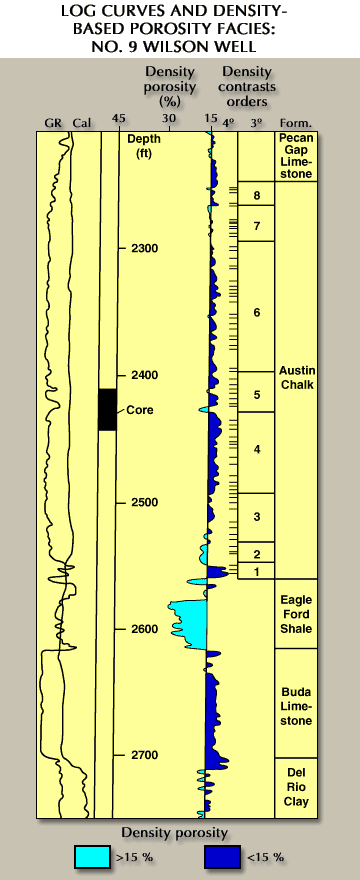
Figure 16. Initial definition of the suite of rock facies that comprise the interwell medium. This preliminary model uses the density log to depict the seismic propagation medium as a series of distinct rock facies that start as a coarse, first-order (1°) compaction trend and end as a detailed assemblage of thin, fourth-order (4°) beds.
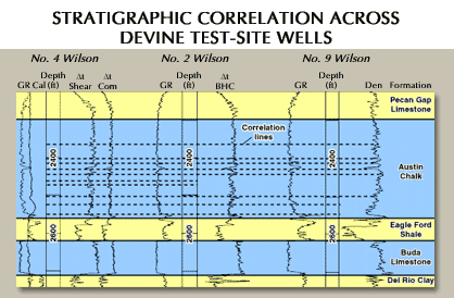
Figure 17. Preliminary stratigraphy and facies model for the interwell P and S propagation medium.
Density logs recorded at the DTS can be segregated into a series of distinct bedding facies of various orders from coarse scale to fine scale. Density-log porosity variations as small as 1 to 2 percent correspond to visually observable compositional changes in core available from the site. This log-density variation is observed at four scales (Figure 16), referred to as first-order (1°) changes through fourth-order (4°) changes.
a. An overall decrease (1° variations) in shale-free limestone porosity that corresponds to increasing density with depth (that is, normal compaction).
b. A formation-scale density behavior (2° variations) that corresponds to rock type; for example, higher density Austin Chalk overlies lower density Eagle Ford Shale, which itself overlies higher density Buda Limestone, etc.
c. Packages 10 to 100 ft thick within the Austin Chalk (3° variations) that are individually characterized by internally consistent density variations. For example, 3° packages No. 1 and No. 4 have density-based porosities that are consistently less than 12 percent, while 3° package No. 2 is characterized by porosities consistently greater than 15 percent.
d. Intervals 2 to 10 ft thick where density-based porosities vary by 1 to 10 percent (4° variations). In the No. 9 Wilson core interval, these variations correspond to changes from relatively pure chalk (lower density-based porosity) to chalk with an increased clay content. These clay-enriched intervals may be depositional features that were deposited as a drape on a pre-existing chalk bed, or they may be pressure-solution features where insoluble clay particles are concentrated as stylolites by solution of calcium carbonate components under burial loading. For example, 3° interval No. 5 is generally characterized by two dense beds (density porosities less than or equal to about 12 percent) that are interbedded with two clay-enriched intervals where porosities are greater than or equal to about 15 percent. However, the dense beds themselves contain several 4° layers that exhibit more detailed density variations.
Many of the well log responses that correspond to rock properties observable in the No. 9 Wilson core can be correlated to log responses at the other wells at the Devine Test Site (No. 2 Wilson and No. 4 Wilson). For example, the gamma-ray and density porosity responses that correspond to two marl-rich intervals at 2,410 and 2,424 ft in No. 9 Wilson (Figures 16 and 17) can be correlated to logs recorded in the other DTS boreholes. Figure 17 presents some examples of correlative horizons, and correlation of more subtle responses is possible.

