
Devine Test Site: Geologic Setting of the Devine Test Site
The Devine Test Site is located in Medina County, approximately 2 miles southwest of Yancey, Texas (Figure 1). The site is located on the northern margin of the Luling Fault Zone (Figures 2 and 3), which is the southern segment of the Luling-Mexia-Talco Fault Zone (LMT) that strikes approximately northeast from the test site area and extends into the northeastern corner of Texas.
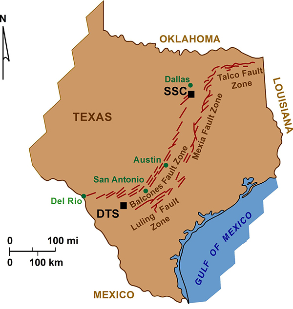
Figure 1. Locations of the Devine Test Site (DTs) and Superconducting Super Collider (SSC) site within the extensional fault zones (Balcones-Luling-Mexia-Talco) that rim the Gulf Coast Basin.
The LMT is east and south of, and parallel to, the Balcones Fault Zone. Both fault zones are characterized by large Cretaceous to Tertiary normal faults, commonly with throws of over 100 ft, and associated smaller faults that mark extension along the margin of the Gulf Coastal Basin (Collins and others, 1992).
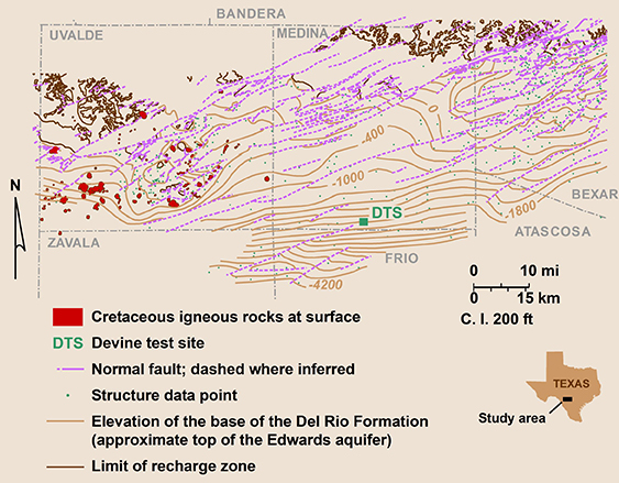
Figure 2. Structure map on the top of the Edwards aquifer with location of the Devine Test Site. Major faults of the Luling Fault Zone trend northeast (from Hovorka and others, 1995).
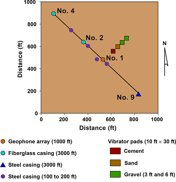
Figure 3. Location of experimental wells at the Devine Test Site. Wells are aligned approximately normal to local fault trends (compare with Figure 2).
At the Devine Test Site, the top of Austin Chalk is 2,250 ft deep, with a thickness of 320 ft (Figure 4). The Austin Chalk is overlain by younger Upper Cretaceous and Eocene rocks, with rocks of the Wilcox Group exposed at the surface. Austin Chalk is a deep-water deposit (Scholle, 1977; Hovorka and Nance, 1994) and has a very fine texture composition throughout its range in Texas, except on the San Marcos Arch (northeast of the test site) where shallow-water, generally coarser grained facies are common (Young and Woodruff, 1985).
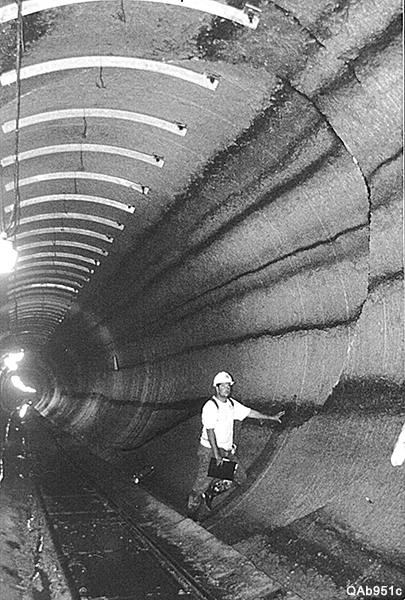
Figure 4. Photograph of tunnel exposure in lower Lower Austin Chalk, SSC site, Ellis County, Texas, showing uniformly thick chalk-marl intervals (typical Austin Chalk), a submarine channel (behind the person), and several normal faults. Note slight marl smears along faults. (Enlarged photo of channel is shown under Vertical Heterogeneity of Austin Chalk, Figure 10.)
Exposures of chalk mapped inside the large tunnels (incrop exposures rather than outcrop exposures??) at the abandoned Superconducting Super Collider (SSC) site, located in the northern extension of the Balcones Fault Zone (Figure 2, above) in north Texas, are useful for describing the chalk at the Test Site because both sites reside in relatively shallow subsurface settings (SSC at a depth of 200 to 400 ft; Devine Test Site at depths of 2250 to 2580 ft) and in extensional fault zones. The Austin Chalk has a similar deep-water depositional origin and composition at both sites (Collins and others, 1992; Nance and others, 1994).

