Wink Sink
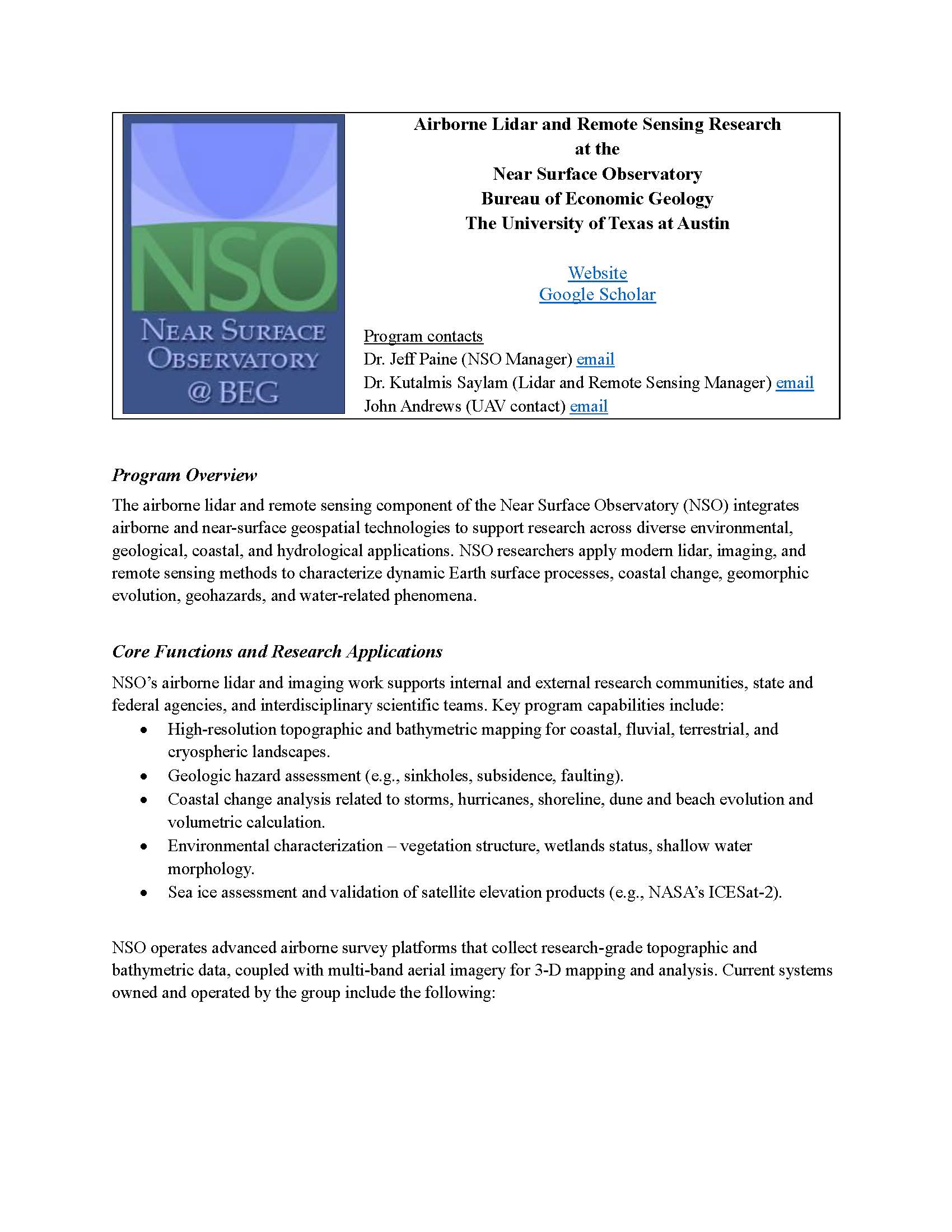
Oblique aerial view of Wink Sink 1, November 2013 (A. Averett).
Overview
Two large sinkholes formed in June 1980 (Wink 1, fig. 1) and May 2002 (Wink 2, figs. 2 and 3) near the communities of Wink and Kermit in the Permian Basin of western Texas (Baumgardner and others, 1982; Johnson, 1989; Collins, 2000; Johnson and others, 2003). These sinkholes formed in the Hendrick Oil Field (discovered in 1926) at the western margin of the Central Basin Platform above the Permian Capitan Reef complex, which underlies Permian interbedded salt and anhydrite at depths of 400 to 670 m (fig. 4). Wink Sink 1, formed on June 3, 1980, measured 110-m across and 34-m deep at the time of collapse. On aerial photographs taken in 2004, it has an approximately circular outline that is 94- to 117-m across and is elongated to the northeast-southwest. The sinkhole encircles the Hendrick No. 10-A, a 780-m deep well that was drilled in 1928, produced oil from the Tansill and Yates formations below the salt section, and abandoned in 1964 (Baumgardner and others, 1982). Flow of unsaturated water from above or below the salt section, possibly through natural or induced fractures or the borehole itself, is the most likely cause of salt dissolution and collapse at Wink Sink 1 (Baumgardner and others, 1982; Johnson et al., 2003).
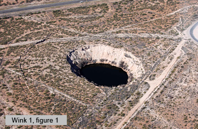
Oblique aerial view of Wink Sink 2, November 2013 (A. Averett).
Wink Sink 2 formed 1.6 km south of Wink Sink 1 on May 21, 2002. This sinkhole has expanded from its original surface width of 137 m to an oval shape with widths ranging from 185 to 250 m, also elongated in the northeast-southwest direction. Both Wink sinkholes have an elongation ratio of about 1.3. Wink Sink 2 encircles the Gulf WS-8, a water-supply well that was drilled through the salt section to 1092 m in 1960 and is estimated to have yielded 800 million bbl of water for waterflood operations in the Hendrick Field (Johnson and others 2003). The cause of collapse at Wink Sink 2 has not been determined, but is thought to be related to the WS-8 well (Johnson and others, 2003). Text adapted from Paine and others, 2012.
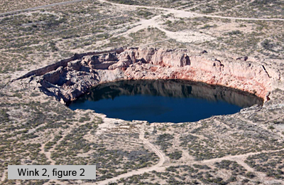
Photograph of Wink Sink 2, June 2008 (J. Paine).
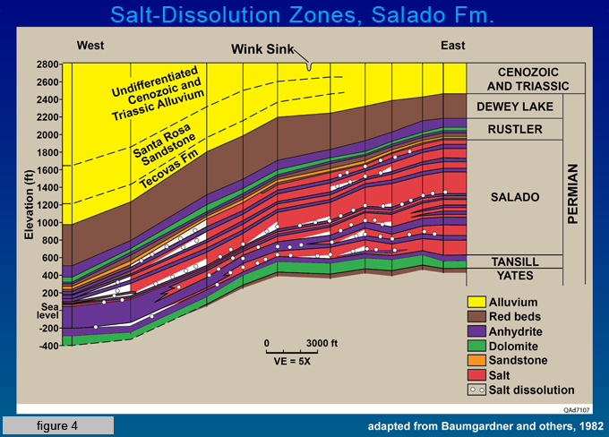
Geologic cross section through the Wink Sink area showing the thick Permian evaporite section beneath the Central Basin Platform (from Baumgardner and others, 1982).
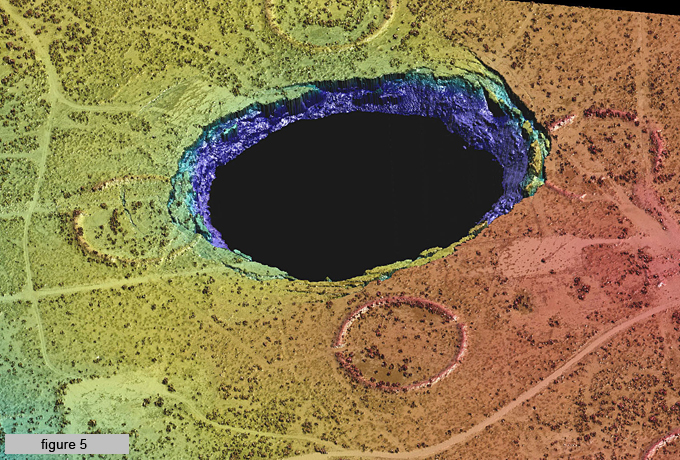
High-resolution digital elevation model (DEM) of Wink Sink 2. This DEM was created from topographic lidar data acquired during an airborne survey conducted by the Bureau in November 2013 (Image by J. Andrews)
Current Research
In November 2013, Bureau researchers conducted an airborne lidar survey of the area surrounding the Wink sinkholes using the Bureau's new Chiroptera system. Data from the survey are being used to create digital elevation models (fig. 5) that will enable researchers to identify areas and estimate amounts of land subsidence since the 1960s near the sinkholes.
The sinkholes have been the subject of several Bureau investigations and publications and continue to be among the most fascinating geological features in the State. Current research is supported by industry gifts and the STARR Geohazard program. These studies supplement recent work by researchers from the Bureau, the Center for Space Research, and UT Permian Basin to measure rates of ground subsidence using satellite radar interferometry, identify shallow mass deficits in key areas using microgravimetry, and map surface expressions of subsidence such as fissures (figs. 6, 7, and 8). Recent studies are summarized in Paine and others (2012).
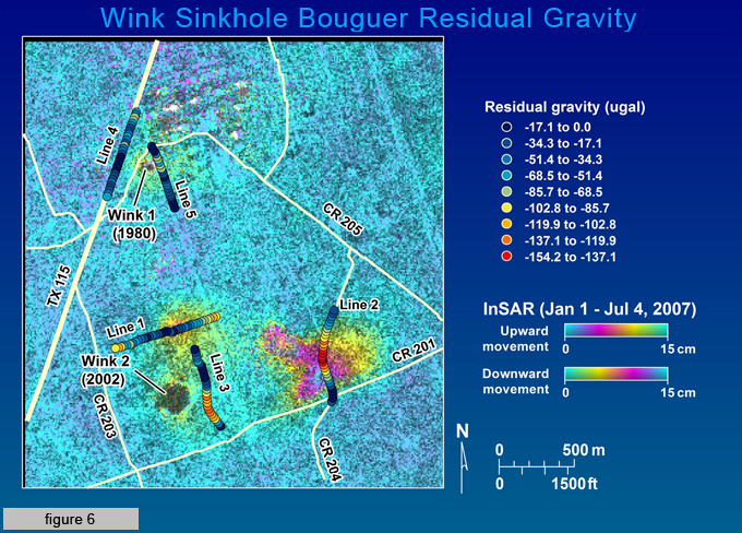
Radar interferometry image (S. Buckley, Center for Space Research) showing 2007 ground subsidence in the area surrounding Wink Sinks 1 and 2. Superimposed on subsidence image are residual gravity anomalies measured by Bureau researchers in June 2008. These data are discussed in Paine and others, 2012.
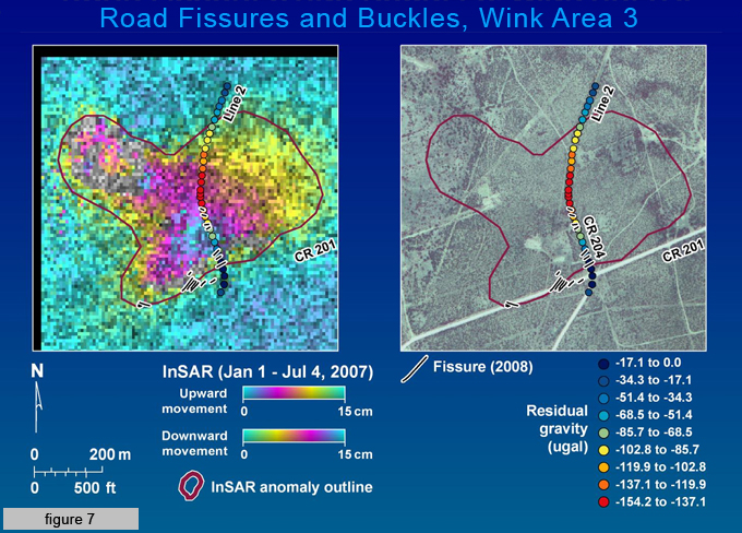
Left: Radar interferometry image (S. Buckley, Center for Space Research) showing 2007 ground subsidence. Superimposed on subsidence image are road fissure and buckle locations and residual gravity anomalies measured by Bureau researchers in June 2008. These data are discussed in Paine and others, 2012.
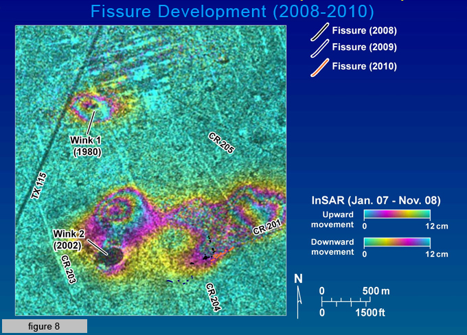
Ground fissures mapped by Bureau researchers in 2008, 2009, and 2010 superimposed on radar interferometry image (S. Buckley, Center for Space Research) depicting ground subsidence between January 2007 and November 2008. These data are discussed in Paine and others, 2012.
References
Baumgardner, R. W., Jr., Hoadley, A. D., and Goldstein, A. G., 1982, Formation of the Wink Sink, a salt dissolution and collapse feature, Winkler County, Texas: The University of Texas at Austin, Bureau of Economic Geology, Report of Investigations 114, 38 p.
Collins, E. W., 2000, Reconnaissance investigation of active subsidence and recent formation of earth fissures near the 1980 Wink Sink in the Hendrick oil field, Winkler County, Texas (abstract): Geological Society of America, South-Central Section, Abstracts with Programs, v. 32, no. 3, p. A-6.
Johnson, K. S., 1989, Development of the Wink Sink in West Texas due to salt dissolution and collapse: Environmental Geology and Water Science, v. 14, p. 81-92.
Johnson, K. S., Collins, E. W., and Seni, S. J., 2003, Sinkholes and land subsidence owing to salt dissolution near Wink, West Texas, and other sites in western Texas and New Mexico: in Johnson, K. S., and Neal, J. T., editors, Evaporite karst and engineering/environmental problems in the United States: Oklahoma Geological Survey Circular 109, p. 183-195.
Paine, J. G., Buckley, S. M., Collins, E. W., and Wilson, C. R., 2012, Assessing collapse risk in evaporite sinkhole-prone areas using microgravimetry and radar interferometry: Journal of Environmental and Engineering Geophysics, v. 17, no. 2, p. 73-87.