
Virtual Cave Tour, Surface/Groundwater Interactions, and Flood Safety
About this presentation

Experience the underground world through a virtual cave tour. Discover how water on the surface can travel underground, through the Edwards Aquifer, to Barton Springs. Use an interactive GIS web map to find out what watershed you live in, whether you live in the recharge zone and/or floodplain, and make your own map. Learn factors that affect flooding in the Austin area and what you can do to protect yourself during a flood.
About the presenter
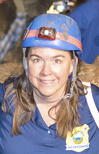
Jessica Gordon
Conservation Program Coordinator
Jessica Gordon is a Conservation Program Coordinator for Austin’s Watershed Protection Department. Her work involves teaching about aquifers, watersheds, and water quality. She is passionate about outdoor environmental education and has over 15 years of experience leading field trips to caves, creeks, and springs. Jessica earned graduate degrees from The University of Texas at Austin in Geography and the Environment and in Science Education. She also chairs the Texas Speleological Association, a non-profit organization that promotes the study, exploration, and protection of caves.
Educational Resources
Video (watch on YouTube)
Presentation (PDF, will be posted after the event)
Educational Resources
Lesson Plan
- Flash Flood Alley, The Power of Water, Grades 6–8 (PDF)