
Kutalmis Saylam
About Kutalmis Saylam
Kutalmis has a background in hydro-geomatics engineering and has completed a number of relevant projects as a principal investigator over the course of his career. Since 2009, he has held an active professional engineering designation from Canada, where he worked in both private and public industries for several years before finally settling at the Bureau. During his time in the private industry, he worked as a Lidar Specialist and traveled extensively to client sites for training, demonstrations, and surveys. He has visited over 30 countries and spent considerable time in the Far East, especially in Japan, where he enjoyed the local cuisine and culture. He is an active Olympic-style competitive archer and he coaches archery in his own club.
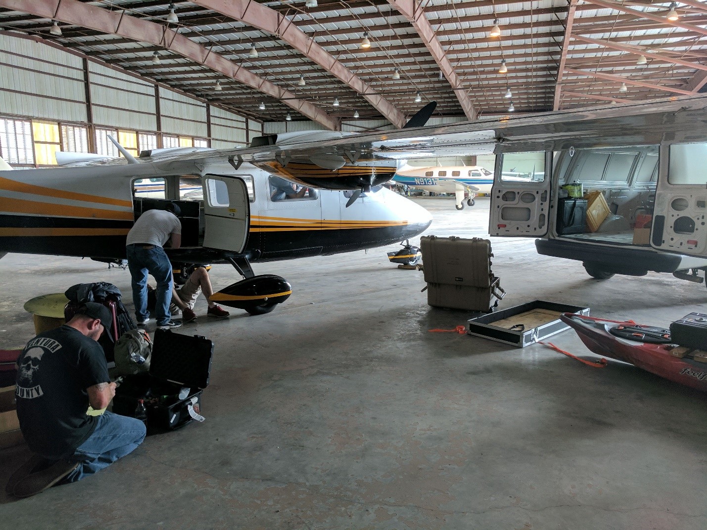
Installing the Chiroptera system before an airborne survey.
What are your current research activities?
I work with Dr. Jeff Paine, who manages the Near Surface Observatory (NSO), and I am responsible for managing the Lidar and remote sensing activities in the group. The NSO group is small; each one of us has a diverse background and specific interests, and we always collaborate with each other. Because my background resides within hydrography and geomatics, I have always been keen on working with research projects that combine both fields. The Bureau has one of only a few operational airborne Lidar systems with hydrographic mapping capability (a Leica AHAB Chiroptera I) in academia. Since the purchase of the Chiroptera in 2012, we have completed multiple research-grade topographic and hydrographic projects at diverse locations—from mapping thousands of thermokarst lakes in the Alaskan tundra to measuring the shallow seafloor along the Gulf of Mexico.
My principal interest is in bathymetric mapping of inland watersheds using the Chiroptera. Because Lidar data quality and accuracy can be impacted by varying environmental conditions, I am investigating and building quality control procedures that apply to hydrographic surveys using multiple remote sensing technologies. In a recent survey in southwest Texas, we used a ground penetrating radar (GPR) to measure the bedrock underneath dense aquatic vegetation where other remote sensing methods such as Lidar and sonar beams did not prevail. Our findings have been very promising!
What excites you the most about your current research?
I get to experience the best of both worlds: field and office (and lately, home). I have worked extensively in the field, leading field crews and supervising fellow researchers and students. I have worked in a variety of locations and diverse environmental conditions: from −15° Celsius in the Arctic to 40° Celsius in the deserts of the southwestern United States. Fieldwork is not easy, but I believe valuable research requires an understanding of accurate data collection at its source and arises with cold or hot temperatures!
Remote sensing, and more particularly Lidar, is an exciting and rapidly advancing technology. In all the years I have been collecting, analyzing, and generating maps using Lidar datasets, I have always been amazed at the precision and detail of the products. It just keeps getting better!
What is the desired outcome of your research?
The desired outcome is to generate accurate and seamless topographic and hydrographic maps of our survey locations that can be utilized in a variety of science disciplines. However, because each project is unique, my goal is to refine and improve overall quality assurance and quality control procedures continually by using cutting-edge remote sensing technologies. Combining accurate and wholesome datasets sourced from different sensors leads to new and improved understanding of the products, pushing the science forward!
What do you need to make your research efforts more successful?
My research relies on collaboration and funding from public and private sponsors. I would like to be able to maintain our good reputation as an academic institution by staying up to date with new advancements in the industry. Remote sensing is comprehensive, and working with a team of highly qualified and specialized researchers is essential as well.
What are your latest papers/publications, and what is most exciting about them?
I recently published an article with collaboration from folks in the industry. I have received much positive feedback, and the article has received a number of citations from other authors since it was published—the highest number of citations in Google Scholar for any publication with the keywords “Lidar bathymetry.”
Saylam, K., Hupp, J. R., Averett, A. R., Gutelius, W. F., and Gelhar, W. B., 2018, Airborne Lidar bathymetry: Assessing quality assurance and quality control methods with Leica Chiroptera examples: International Journal of Remote Sensing, v. 39, no. 8, p. 2518–2542, doi:10.1080/01431161.2018.1430916.
Who will benefit from your latest paper or publication?
We have recently concluded a study in the Devils River, in southwestern Texas, which has a karstic and fluvial environment. We used a variety of geodetic instruments to measure the river bedrock underneath a dense layer of aquatic vegetation. Combining all the datasets sourced from different instruments was exciting and very challenging! I will be publishing an article soon which explains all the efforts and the results. I believe anyone concerned with airborne Lidar or who has access to remote sensing instruments for generating hydrographic studies will be able to benefit from this article.
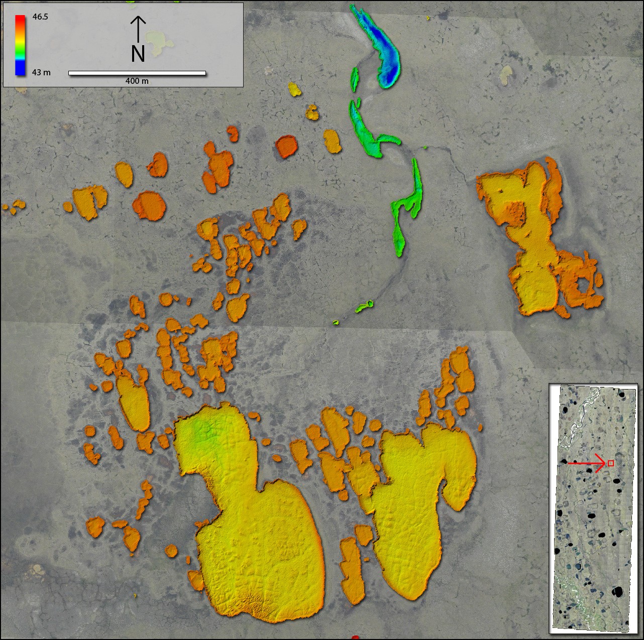
Lidar digital elevation model of thermokarst lakes in the Alaskan North Slope.
What was your most exciting past paper or publication, and why?
My most exciting past paper is possibly my first peer-reviewed article, published in 2017. I enjoyed the project overall, especially the trip to the Alaskan tundra. Using the Chiroptera, we managed to map thousands of thermokarst lakes in a matter of a few weeks. We analyzed the transparency of each lake using high-resolution satellite imagery and correlated our results to the Lidar measurements. The Lidar data is comprehensive and very useful for a variety of studies in limnology. Since it was published, the article has received several citations.
Saylam, K., Brown, R., and Hupp, J. R., 2017, Assessment of depth and turbidity with airborne Lidar bathymetry and multiband satellite imagery in shallow water bodies of the Alaskan North Slope: International Journal of Applied Earth Observation and Geoinformation, v. 58, p. 191–200, doi:10.1016/j.jag.2017.02.012.
Who are the types of research partners you are seeking, and what skills or expertise could benefit your research?
Our group welcomes research opportunities from public and private industries to explore innovative applications of topographic and bathymetric Lidar. We take pride in our established quality control mechanisms and our group’s expertise with spectral imaging. We have access to a variety of remote sensing tools and applications, and we are interested in projects that require the following:
- Creating detailed watershed topographic models
- Characterizing dynamic Earth systems and change over time (temporal analysis)
- Determining uplift and downdrop rates in tectonically active areas
- Conducting rapid-response surveys for hazard assessment
- Quantifying vegetation assemblages and invasion of nonnative species through aquatic and terrestrial ecosystems
- Building mesohabitats models
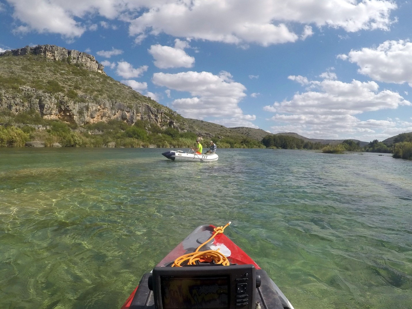
Devils River survey with a ground penetrating radar and a sonar.
What are the desired relationships, expertise, or skills that could be brought in to benefit your research?
As we have demonstrated in the Devils River project, combining geodetic, geospatial, and geophysical datasets has proven to be fruitful for building seamless hydrographic maps. Another exciting potential update is the no-cost data availability of NASA’s Ice, Cloud and Land Elevation Satellite (ICESAT-2), which became operational in September 2018. The satellite carries a photon-counting Lidar unit with a 10-KHz scanner operating with green-wavelength energy, and will potentially be very beneficial for taking depth measurements at remote locations where in situ measurements are not feasible. I will be focusing on investigating the ICESAT-2 data and its accuracy for use as another hydrographic mapping tool.
What have been recent successes associated with your research?
In the Devils River study, we used a novel approach to measure the depths underneath the aquatic assemblage using a ground penetrating radar. The results look very promising, and we were able to integrate the radar measurements with Lidar and sonar datasets.
What is the geographic location of your research?
My research can be applied to any geographic region with a diverse natural environment. We have completed research projects from the California shoreline to the Alaskan North Slope to the Deep South, where we measured depth and generated maps of inland watersheds.
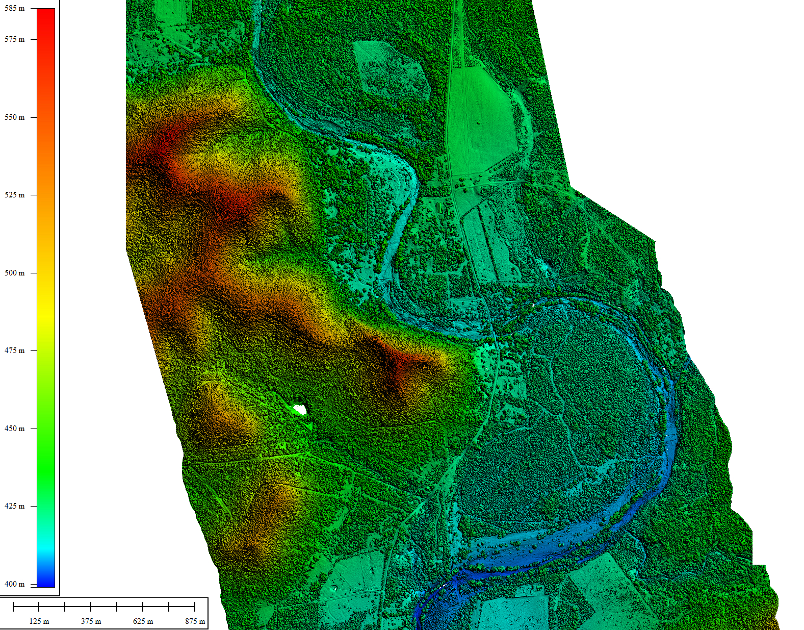
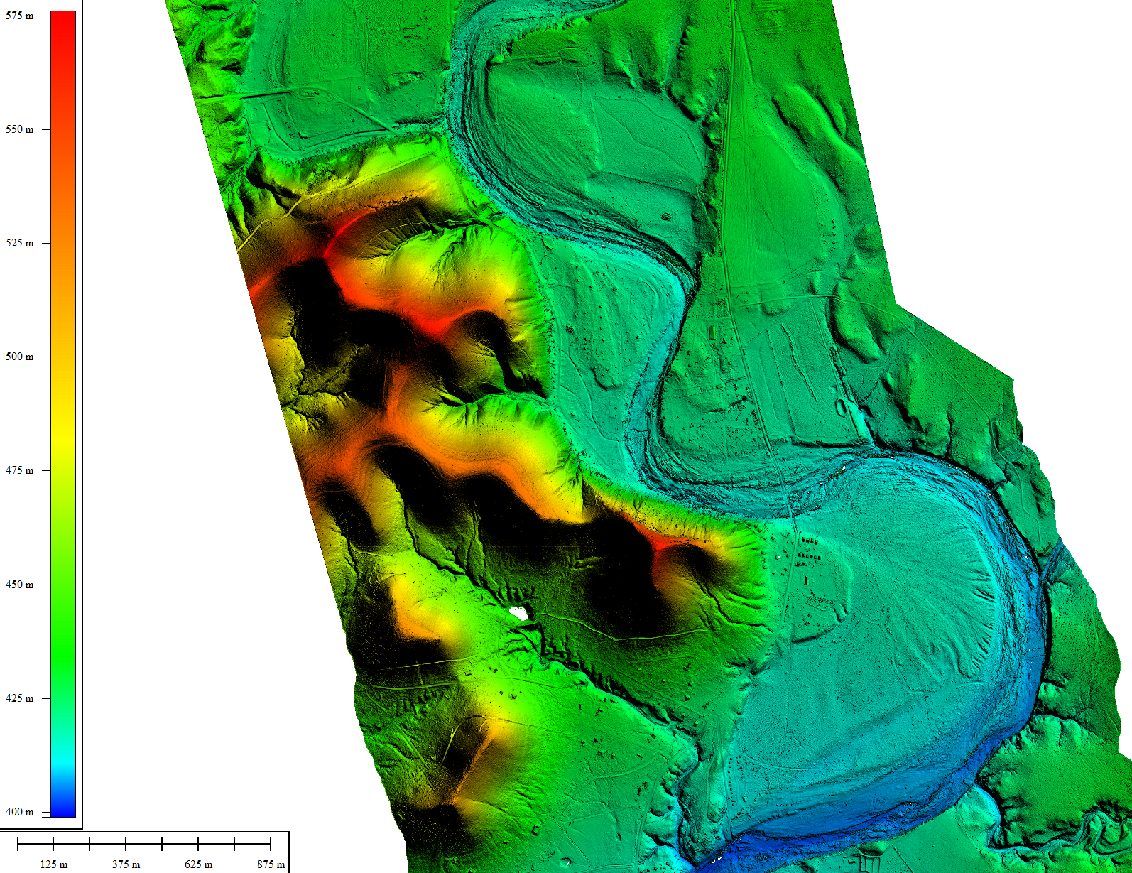
Digital surface model of the Frio River by Garner State Park, Texas. Click to enlarge.
Bare earth model of the Frio River by Garner State Park, Texas. Click to enlarge.

