
TexNet and CISR Provide New Insights in Fort Worth Basin Earthquake Study
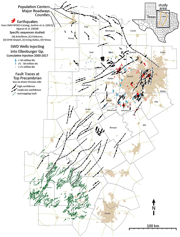
A simplified version of the fault map created by the research teams includes faults that are visible at the surface (green) and underground faults (black). Solid lines indicate underground faults mapped at high resolution, while dotted lines indicate faults mapped at medium resolution.The map also marks earthquake locations and waste-water injection well locations and amounts. Credit: Hennings et al.
Recent research results from the TexNet Seismic Monitoring Network and Center for Integrated Seismic Research(CISR) provide new insights into the potential for earthquakes in the Fort Worth Basin in north-central Texas. Working with researchers from Stanford and SMU, Bureau of Economic Geology researchers have created a comprehensive map of more than 250 faults totaling more than 1,800 miles in length in the region. Among the conclusions of the study is that the majority of faults underlying the Fort Worth Basin are as sensitive to variations in stress that might cause them to slip as those that have produced earthquakes in previous years. The region experienced a significant increase in seismic activity from 2008 through 2015 as energy production ramped up, and a reduction in earthquakes in recent years as production activity slowed.
“Most of the faults that have slipped are too small to have been previously recognized; they’re very difficult to find,” said CISR principal investigator Peter Hennings. “We certainly haven’t identified all of the faults in the region, but this new work is a big improvement compared to what was previously available.” Published in the July 23 Bulletin of the Seismological Society of America, the new study concludes that left undisturbed, the faults are relatively stable. But the potential of the faults to slip, with resultant earthquakes, increases significantly with wastewater injection, a common practice during oil and gas operations, if the process is not managed properly.
While the new map provides a better understanding of the seismic hazards beneath one of the nation’s most heavily populated areas, according to Hennings there is still more resolution to be gained in their study of seismic hazards. “In 2020, we will be publishing an updated version of the fault map as well as a comprehensive model that indicates the degree of pressurization that each of the earthquake faults has experienced from wastewater disposal,” he said. “Combined with this current work, the future research will give industry and our regulators powerful tools to use in managing the hazard and reducing risk.”
TexNet was authorized and funded by the Texas Legislature and Gov. Greg Abbott, and has been tracking seismic activity statewide since 2017. Operated and managed by the Bureau, TexNet also provides a public data portal for real-time seismic activity across the state on the TexNet Earthquake Catalog website. CISR is a multidisciplinary consortium of academic and industry partners collaboratively pursuing a wide range of seismicity research topics. To learn more about this recently published study, read the official University of Texas at Austin press release.

