
RCRL Outcrop-Based Research Enters the Next Phase
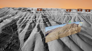
Figure 1. Digital outcrop model with interpreted
horizons. Logos represent areas with detailed
information such as the interpreted image that
is placed in the VR environment. Image from Price
and others, 2021, RCRL presentation.
The carbonate Reservoir Characterization Research Laboratory (RCRL) is a program built on the principal that outcrop exposures are a fundamental link to the explanation and description of 3D reservoir environments in the subsurface. The recent pandemic has revealed two challenges of the outcrop—characterization of the valuable complexities shown in the exposures and how to get more geoscientists to see and appreciate these in their every day work.
Techniques that bring the outcrop to the geoscience desktop has been at the forefront of RCRL research. Since its inception in 1987, the RCRL group has led the field in applying tools such as high-resolution panoramic photography, ground-based and airborne lidar, differential GPS mapping, and drone-based photogrammetry to better characterize carbonate reservoir analogs. The detailed outcrop characterization work is used to illuminate complex correlations between cores, wireline logs, and seismic data
Amassing a large catalog of characterized digital outcrops, RCRL is now embarking on the next phase of bringing the outcrop to the desktop—virtual reality. Today’s geoscientists are faced with growing demands on their time or restrictions on their travel (e.g., recent COVID issues). Furthermore, not every geoscientist is capable of reaching some of the more challenging locations that are required to see firsthand the perfect spot for understanding their reservoir.
There are two approaches being used by RCRL to put the geology on the desktop. The first involves creating digital outcrop models in virtual reality (VR) environments. In VR, users traverse through digital outcrops in a similar way that modern video games allow first-person streaming of fictional worlds. However, the VR world developed by RCRL is a high-quality replication of the outcrop. As a user virtually walks through the outcrop, the user is able to see the important interpretations placed on the outcrop by an experienced field geologist and can see tagged relevant references such as an interpreted photograph (fig. 1) or can see a subsurface wireline log correlation that is similar to the scale of the exposure being visualized.
A second approach of bringing the outcrop to a wider audience is the documentation of classic and new field trips by video filming each stop as it presented by a field trip leader. As many geoscientists are aware, nothing beats having an expert point out the value and insight an outcrop provides to their understanding. RCRL’s recent field trip to the Sacramento Mountains was captured on video in two ways. The first was the standard filming of the leader presenting their work (fig. 2 video) while the second was a 360-degree camera simultaneously capturing the outcrop and the field trip leader’s description (video - be sure to use your mouse to rotate the video!).
Outcrops and field trips will always be a fundamental part of geology, but new techniques provide people with valuable insight from the view of world experts. The RCRL team continues to find innovative ways to bring this experience to people that need it the most.
On that note, preparations are underway for a field trip to the Keeler and Darwin Basins in the Death Valley, CA area. Stay tuned! You may soon be able enjoy this experience from the comfort of your desk chair!
For more information on the RCRL or to join, please contact Chris Zahm or Xavier Janson.
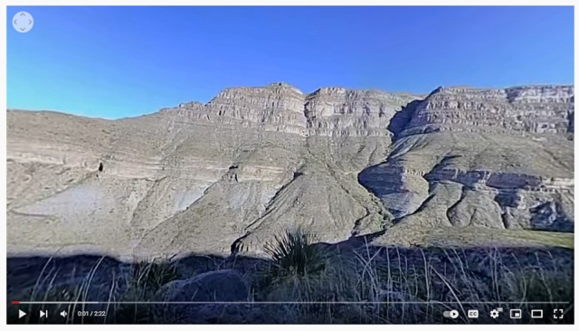
Figure 2. Screen grab from field trip video in Dog Canyon, NM.

