
Texas GeoSign Project

The Texas GeoSign Project was launched by the Bureau of Economic Geology in 2016 to establish a network of geologic information signs to engage and educate people when they visit parks, highway rest areas, and other public locations. This program was expanded in 2020 to identify Texas Geoheritage sites and encourage good stewardship of these natural resources.
Geoheritage Initiative
“Geoheritage” is a generic but descriptive term applied to sites or areas of geologic features with significant scientific, educational, cultural, and/or aesthetic value.
The Bureau is developing an inventory of Texas Geoheritage sites available here.
Please join in this effort by sharing your ideas. Nominate a site in Texas for geoheritage designation by filling out the information on the survey at the link below. Thank you.
Click to see larger version
Knox County Safety Rest Area GeoSign
Knox County, Texas
Latitude = 33.5900, Longitude = -99.7169
(Physical sign installation coming soon)
Excerpts from the Knox County Safety Rest Area GeoSign
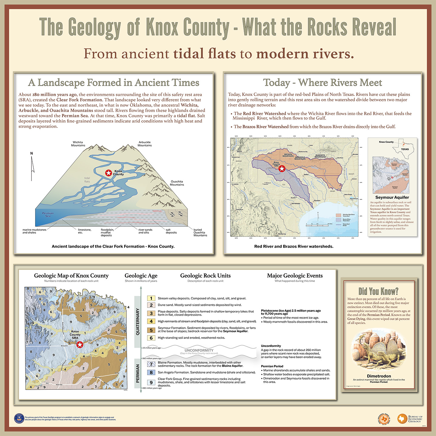
A Landscape Formed in Ancient Times
About 280 million years ago, the environments surrounding the site of this safety rest area (SRA), created the Clear Fork Formation. That landscape looked very different from what we see today. To the east and northeast, in what is now Oklahoma, the ancestral Wichita, Arbuckle, and Ouachita Mountains stood tall. Rivers flowing from these highlands drained westward toward the Permian Sea. At that time, Knox County was primarily a tidal flat. Salt deposits layered within fine-grained sediments indicate arid conditions with high heat and strong evaporation.
Click to see larger image
Guadalupe River State Park
Comal County, Texas
Latitude = 29.874949 Longitude = -98.485118
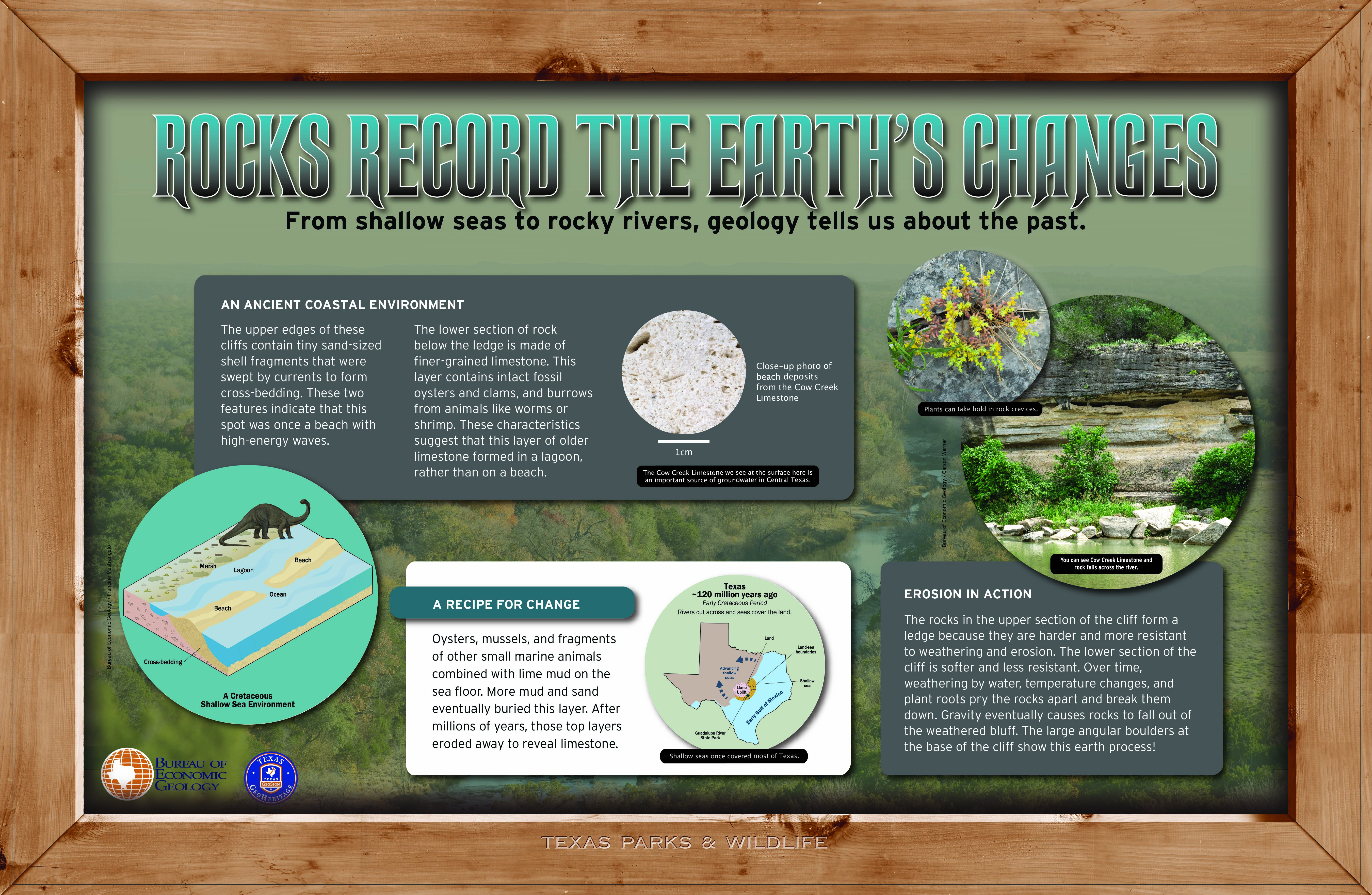
Excerpts from the Guadalupe River State Park Texas GeoSign
An Ancient Coastal Environment
The upper edges of these cliffs contain tiny sand-sized shell fragments that were swept by currents to form cross-bedding. These two features indicate that this spot was once a beach with high-energy waves.
The lower section of rock below the ledge is made of finer-grained limestone. This layer contains intact fossil oysters and clams, and burrows from animals like worms or shrimp. These characteristics suggest that this layer of older limestone formed in a lagoon, rather than on a beach.
Click to see larger image
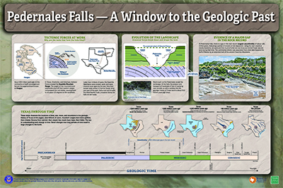
Pedernales Falls State Park Texas GeoSign
Latitude = 30.3367083333 Longitude = -98.2509055556
Excerpts from the Pedernales Falls State Park Texas GeoSign
Evidence of a Major Gap in the Rock Record
At Pedernales Falls, there is a gap in the rock record (angular unconformity) of about 180 million-years, indicating a period of erosion or non-deposition. Using the rock record at nearby locations, we conclude that much of what we now know a Central Texas was dry land during that time. The continental interior was separated from what later became the Gulf of Mexico by an extended belt of the ancient Ouachita Mountains.
Geology of Pedernales Falls State Park
A hiker’s guide which includes a geologic map and points of interest.
An English version can be viewed here.
A Spanish version can be viewed here.
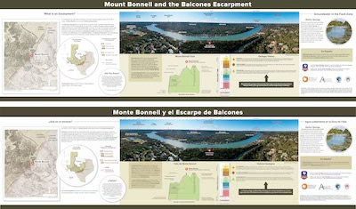
Mount Bonnell
Austin, Texas
Latitude = 30.32072 Longitude = -97.77347
Excerpts from the Mount Bonnell Texas GeoSign
What is an Escarpment?
An escarpment is an area where the elevation of the earth changes suddenly forming a line of hills or scarps. At Mount Bonnell, you are atop the Balcones Escarpment.
The Balcones Escarpment runs through Central Texas from Austin, southwest through San Antonio, and from there to the Rio Grande (Big River) near Del Rio. It marks the boundary between the Great Plains stretching west, and the Gulf Coastal Plain to the east. The break in the landscape defines major differences in earth resources, weather and climate, soils, vegetation, and animal habitats. East of the escarpment are the prime farmlands of the Blackland Prairies; to the west are the rangelands and woodlands of the Hill Country and the Edwards Plateau. The Balcones Escarpment marks the beginning of the American West in terms of landscape, ecology, geologic processes, and human endeavors.
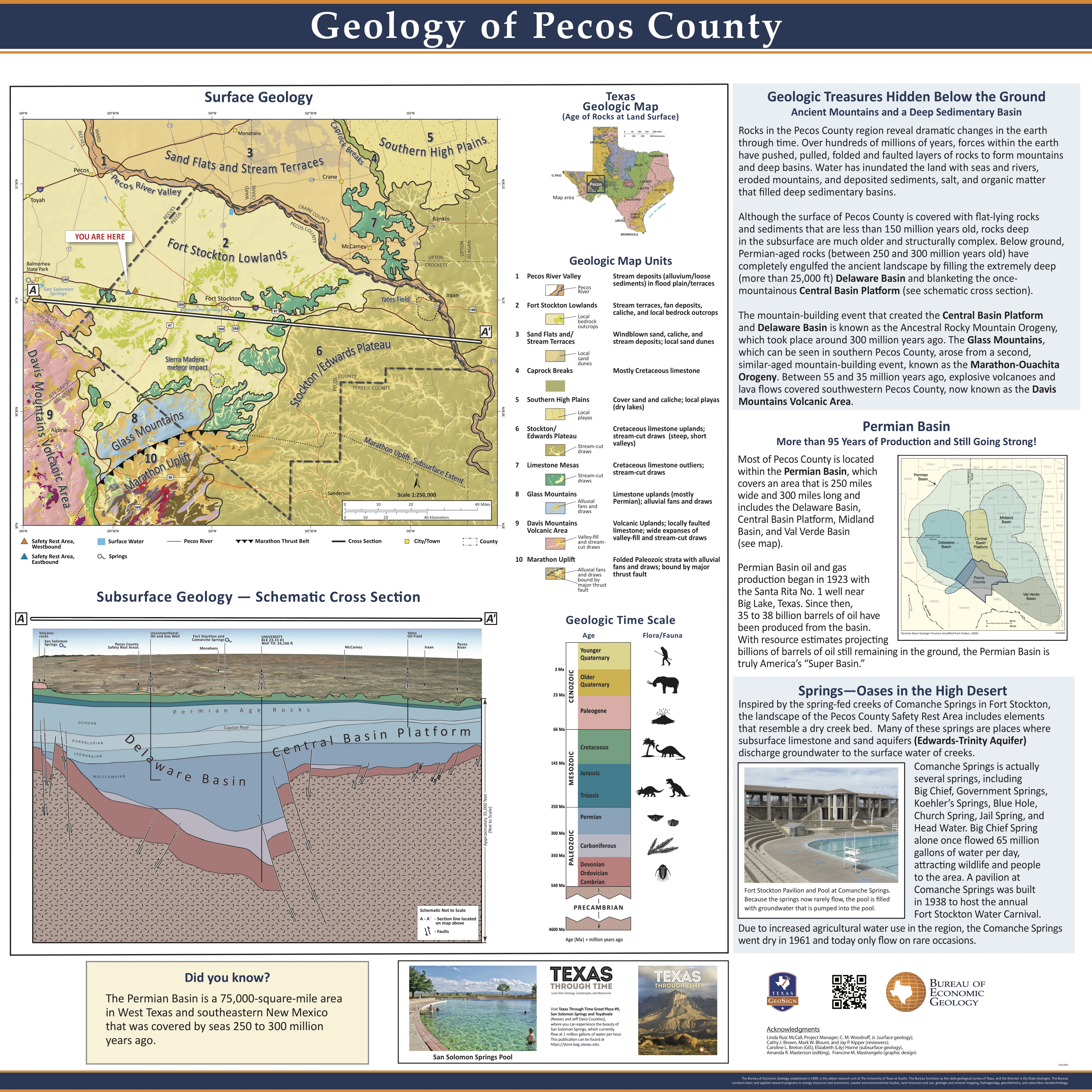
Pecos County Safety Rest Area
IH 10 - Eastbound, 26 miles west of Ft. Stockton
Latitude = 30.9388 Longitude = -103.3139
IH 10 - Westbound, 26 miles west of Ft. Stockton
Latitude = 30.9378 Longitude = -103.3052
Excerpt from the Pecos County Texas GeoSign
Rocks in the Pecos County region reveal dramatic changes in the earth through time. Over hundreds of millions of years, forces within the earth have pushed, pulled, folded and faulted layers of rocks to form mountains and deep basins. Water has inundated the land with seas and rivers, eroded mountains, and deposited sediments, salt, and organic matter that filled deep sedimentary basins.
Although the surface of Pecos County is covered with flat lying rocks and sediments that are less than 150 million years old, rocks deep in the subsurface are much older and structurally complex. Below ground, Permian-aged rocks (between 250 and 300 million years old) have completely engulfed the ancient landscape by filling the extremely deep (>25,000 ft) Delaware Basin and blanketing the once-mountainous Central Basin Platform.
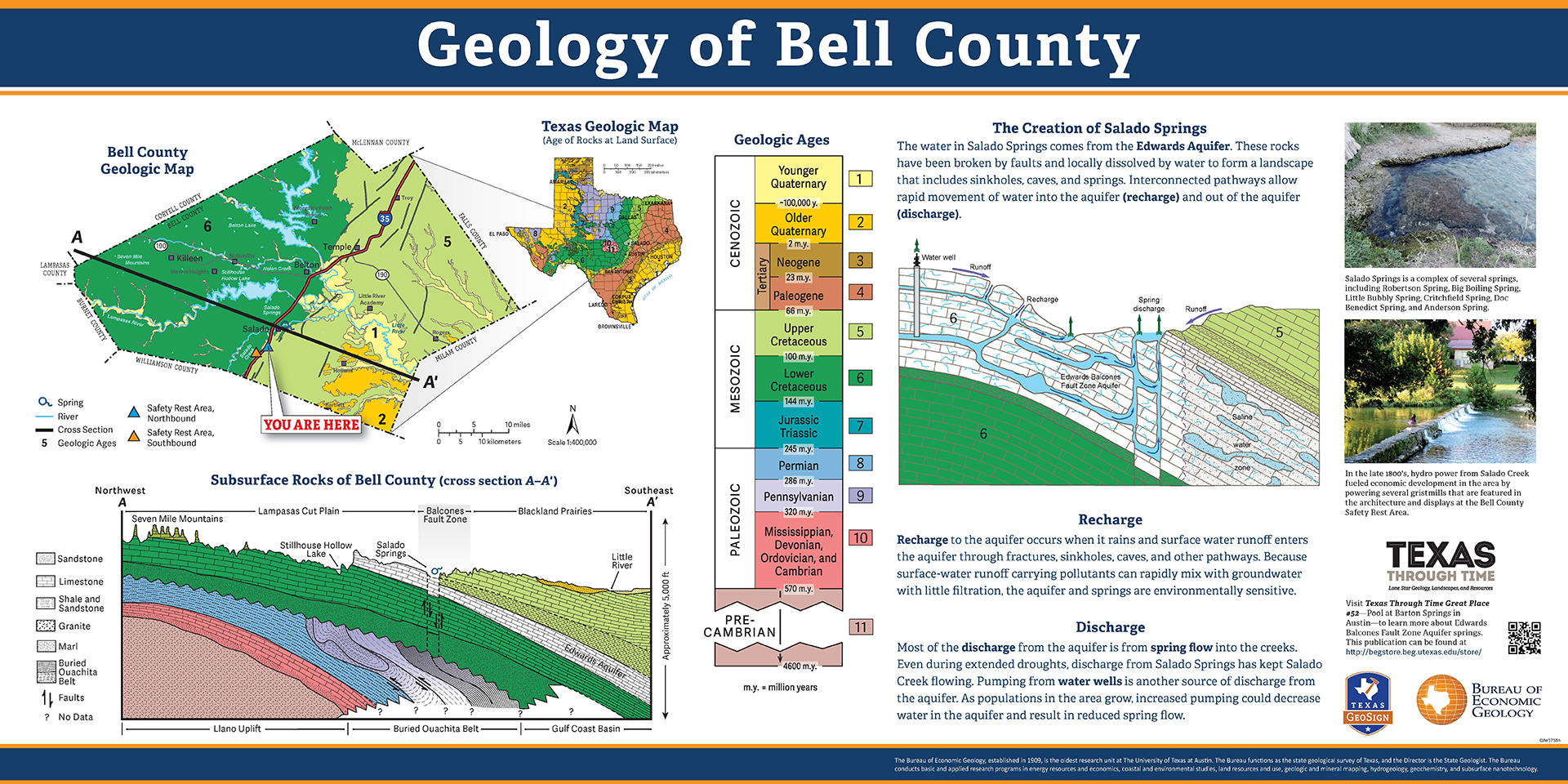
Bell County Safety Rest Area
IH 35 - Northbound, approximately 2 miles south of Salado, midway between Austin and Waco
Latitude = 30.9001 Longitude = -97.5623 Milepost: 281
IH 35 - Southbound, approximately 2 miles south of Salado, midway between Austin and Waco
Latitude = 30.9137 Longitude = -97.5508 Milepost: 282
Excerpts from the Bell County Texas GeoSign
The water in Salado Springs comes from the Edwards Aquifer. These rocks have been broken by faults and locally dissolved by water to form a landscape that includes sinkholes, caves, and springs. Interconnected pathways allow rapid movement of water into the aquifer (recharge) and out of the aquifer (discharge).
Salado Springs is a complex of several springs, including Robertson Spring, Big Boiling Spring, Little Bubbly Spring, Critchfield Spring, Doc Benedict Spring, and Anderson Spring. In the late 1800's, hydro power from Salado Creek fueled economic development in the area by powering several gristmills that are featured in the architecture and displays at the Bell County Safety Rest Area.
Click to see larger image.
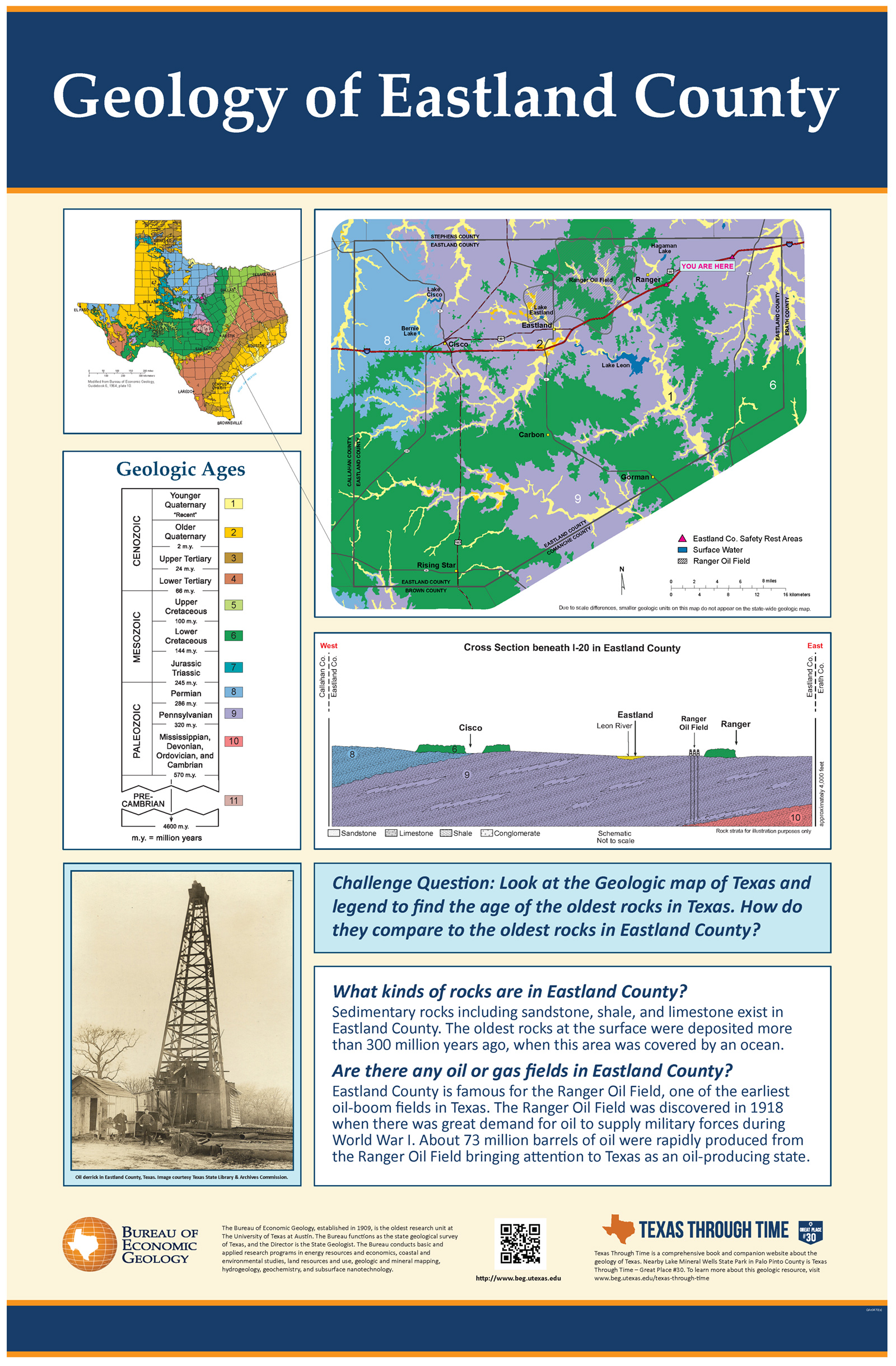
Eastland County Safety Rest Area
IH 20 - Westbound, 8 miles east of Ranger (between Ranger and Thurber)
Latitude = 32.4906 Longitude = -98.5492
IH 20 - Eastbound, just east of Ranger
Latitude = 32.4569 Longitude = -98.6483
Excerpts from Eastland County Texas GeoSign
What kinds of rocks are in Eastland County?
Sedimentary rocks including sandstone, shale, and limestone exist in Eastland County. The oldest rocks at the surface were deposited more than 300 million years ago, when this area was covered by an ocean.
Are there any oil or gas fields in Eastland County?
Eastland County is famous for the Ranger Oil Field, one of the earliest oil-boom fields in Texas. The Ranger Oil Field was discovered in 1918 when there was great demand for oil to supply military forces during World War I. About 73 million barrels of oil were rapidly produced from the Ranger Oil Field bringing attention to Texas as an oil-producing state.
Click to see larger image.
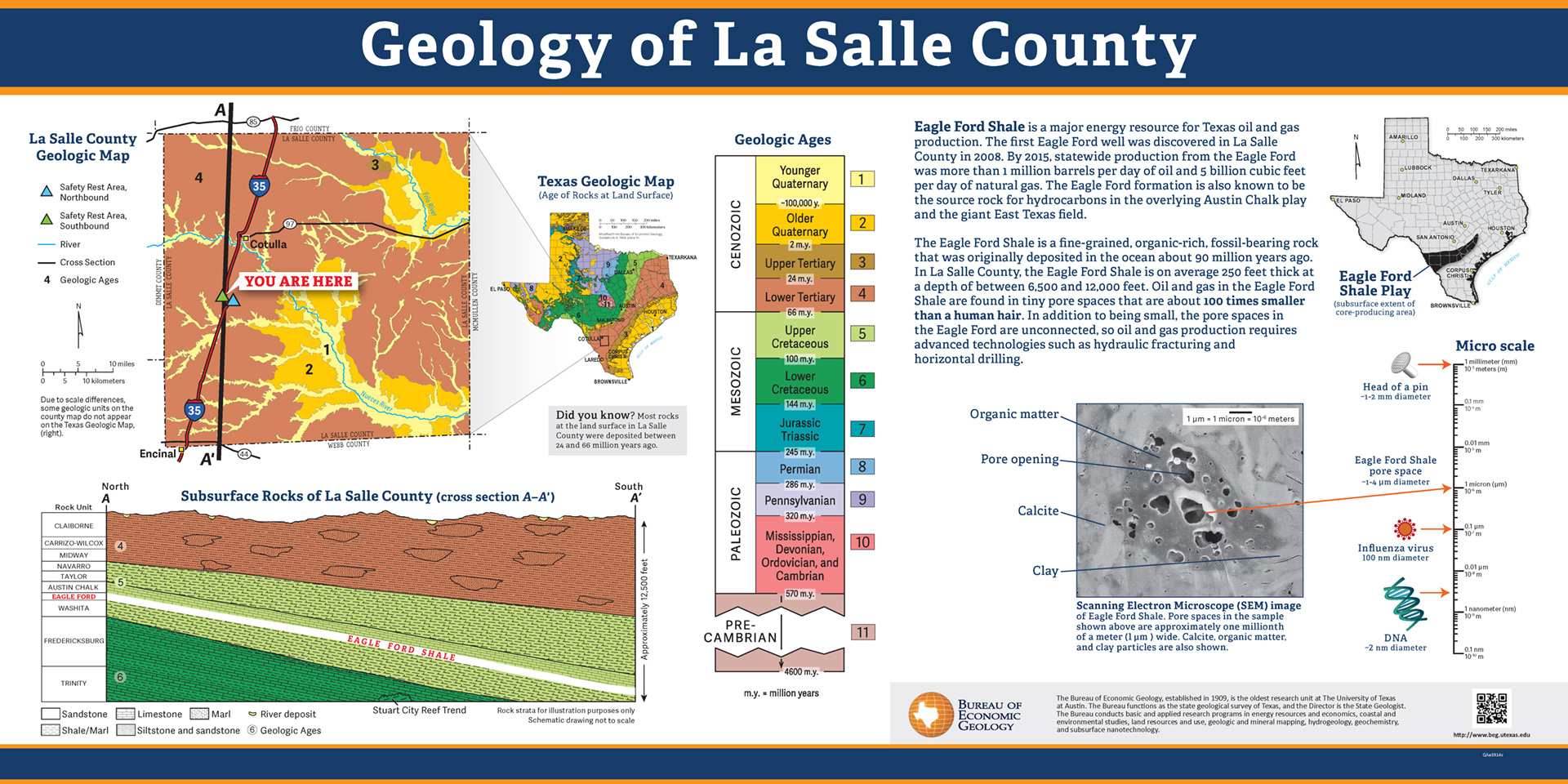
La Salle County Safety Rest Area
IH 35 - Northbound, approximately 8 miles south of Cotulla
Latitude = 28.3196 Longitude = -99.2745
IH 35 - Southbound, approximately 8 miles south of Cotulla
Latitude = 28.3237 Longitude = -99.276
Excerpts from La Salle County Texas GeoSign
Eagle Ford Shale is a major energy resource for Texas oil and gas production. The first Eagle Ford well was discovered in La Salle County in 2008. By 2015, statewide production from the Eagle Ford was more than 1 million barrels per day of oil and 5 billion cubic feet per day of natural gas. The Eagle Ford formation is also known to be the source rock for hydrocarbons in the overlying Austin Chalk play and the giant East Texas field.
The Eagle Ford Shale is a fine-grained, organic-rich, fossil-bearing rock that was originally deposited in the ocean about 90 million years ago. In La Salle County, the Eagle Ford Shale is on average 250 feet thick at a depth of between 6,500 and 12,000 feet. Oil and gas in the Eagle Ford Shale are found in tiny pore spaces that are about 100 times smaller than a human hair. In addition to being small, the pore spaces in the Eagle Ford are unconnected, so oil and gas production requires advanced technologies such as hydraulic fracturing and horizontal drilling.
Click to see larger image
Goat Cave Karst Preserve
Located in South Austin near the intersection of Brodie Lane and Deer Lane in Austin, Texas
Latitude = 30.1972 Longitude = -97.8477
Excerpts from the “Recharge Zone in a Karst Terrain” GeoSign
The Goat Cave Karst Preserve is located in highly fractured rock formations containing several caves and interconnected passages. This karst terrain is considered environmentally sensitive to contamination because surface water runoff can rapidly enter into the subsurface groundwater with little filtration. Excess fertilizers, pesticides, pet waste, trash, sediments, and other pollutants on the land surface can enter into streams during rainfall events and quickly enter into the aquifer. Water entering the aquifer in the recharge zone can flow to Barton Springs in only a few days.

