
Robin Dommisse
About Robin Dommisse
Robin Dommisse is a Research Scientist Associate at the Bureau of Economic Geology. He received a B.Sc. in Petroleum Engineering from The University of Texas at Austin and a Propaedeuse in Geology from the Free University of Amsterdam. He developed an interest in geomodeling while working as a student in the RCRL group during his first tour of duty at the Bureau from 1989 to 1993. For 25 years, Robin ran the Austin Geomodeling Company, which he founded to serve the oil and gas industry through the development of geoscience software and the completion of over 40 integrated 3D reservoir characterization studies for a range of major, independent, and national oil companies. Four years ago, he returned to the Bureau to focus on geomodeling research in Dr. Scott Tinker’s BEG Shale Play Study Research Team and Dr. Charles Kerans’ Reservoir Characterization Research Laboratory.
Robin's background is in geology and petroleum engineering. His areas of expertise include integrated 3D geocellular modeling, seismic interpretation, reservoir simulation, hydrocarbon reserves assessment, petrophysics, and sequence stratigraphic well log interpretation. At the Bureau, he has contributed to various industry associate programs and research groups, including RCRL, TORA, MSRL, Texnet, CISR, SUTUR, FRAC, and STARR.
What are your current research activities?
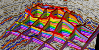
High-resolution sequence stratigraphic framework of the SACROC field, Permian Basin.
My research focuses on building integrated, multidisciplinary, sequence stratigraphic 3D geomodels consisting of integrating outcrop, core, seismic, well log correlations, and production data. My research involves the development of the BEG’s regional geocellular models for the Permian Basin and Gulf Coast. These studies integrate the latest 3D seismic and well log based stratigraphic and structural correlations with petrophysical and fluid attributes to serve as the foundation for basin-wide reservoir characterization research. Other research activities include building an improved shelf-to-basin framework for the Central Basin Platform to Midland Basin transition using improved time-depth conversions. At the reservoir scale, we will focus on step-out characterization of the Midland Basin G10-11 grainstone systems from the Midland Farms Unit, to Mabee Field, and surrounding satellite fields for hydrocarbon prospects and volumetrically constrained saltwater disposal (SWD) targets. Other reservoir scale research will include well-pad level characterization of the Wolfcamp, through the construction of an integrated 3D geological model for the Hydraulic Fracture Test Site 1 area (HFTS1) in the Midland Basin. This study focused on well productivity drivers related to observed natural fractures in the slanted HFTS1 core.
What excites you the most about your current research?
At no other time in the history of the BEG have so many large datasets become available for geoscience research in the State of Texas. It is the opportunity of a lifetime to be able to work with so many world-class experts across many disciplines and departments in projects that range in size and scope from regional studies, to the reservoir level, and the individual well pad scales.
What is the desired outcome of your research?
The purpose of creating the integrated 3D geological models in our research is to integrate the BEG’s geological understanding of regional geology with detailed reservoir-scale interpretations. These 3D models are applicable to a wide variety of research areas relevant to the decision-making processes of our industry sponsors and the oil & gas industry at large. Our research results include insights into controls on sediment routing; 3D facies architecture of unconventional reservoirs; shelf-to-basin correlations of the Permian Basin; mature field reservoir characterization; enhanced oil recovery; analysis of seismicity; and CO2 sequestration.
What do you need in order to make your research efforts more successful?
The value of our research is directly related to the quality and quantity of the data provided to us by our industry sponsors, partners, and publicly available sources. The critical understanding of today’s industry challenges resides in the combined minds and recorded experience of the many professional geoscientists who tackle real-world energy sector problems daily. Drawing upon the expertise of these industry partners and attempting to help them to analyze and interpret their data will make our research efforts more successful.
What are your latest papers/publications, and what is most exciting about them?

Midland Basin horizontal oil producers in the Wolfcamp tight-oil exploration and production play.
Gale, J. F. W., Baumgardner, R., Bhandari, A., Darvari, R., Dommisse, R., Eichhubl, P., Elliott, S. J., Fall, A., Flemings, P., Hamlin, H. S., Landry, C. J., Mohanty, K., Nicot, J.-P., Polito, P., Prodanović, M., Ramiro-Ramirez, S., Reed, R. M., Rowe, H., Ruppel, S. C., and Sivil, J. E., 2019, Multi-faceted study of water cut in the Permian Wolfcamp in the Delaware Basin, West Texas: final report prepared for Shell, under contract no. UT OSP# 201503146-001, 292 p.
It was a great privilege to work with my friend and mentor, the late Steve Ruppel, on a high-resolution stratigraphic framework of the Wolfcamp in the Delaware Basin. Being able to draw upon Steve’s decades of experience and insight into the Paleozoic strata of the Permian Basin added an unparalleled level of sophistication and accuracy to the resulting unconventional reservoir geomodels we produced.
Dommisse, R., Kerans, C., Zahm, C., Male, F., Pollock, S. and Bianco, R., 3-D Integrated Geological Model Construction of Fasken Ranch Area, Midland Basin, Texas. In 2019 AAPG Annual Convention and Exhibition.
Kerans, C., Dommisse, R., Rush, J. and Waite, L., Contrasting Guadalupian Infill Histories of the Midland and Delaware Basins. In 2019 AAPG Annual Convention and Exhibition.
Kerans, C., Dommisse, R., Zahm, C., Pollack, S., Bianco, R., Draper, C., and Wahlman, G., 2018, Contrasting styles of basin fill and shelf margin stacking, Wolfcampian-Leonardian Guadalupian succession, eastern margin of Central Basin Platform and Western Midland Basin, Fasken Ranch Area, West Texas, In 2018 AAPG Annual Convention and Exhibition.
Charlie Kerans’ research, integrating more than 30 years of his Permian Basin outcrops analysis, core-based sedimentological models, and regional stratigraphic interpretations, combined with the Fasken Ranch 3D seismic survey from the Fasken Oil & Ranch company, provided a unique opportunity for important research into the critical shelf-margin to basin transitions for the complete Permian section. The three-dimensional models we developed using the integration of depth-converted seismic, log, core, and production data allowed for the recognition of distinct styles of basin fill and reservoir facies development.
Who will benefit from your latest paper or publication?
Energy companies with exploration and production operations in the Permian Basin and Gulf Coast unconventional plays; oil & gas companies with secondary and tertiary oil recovery projects, including carbon capture, utilization, and storage (CCUS), and residual oil zone (ROZ) enhanced oil recovery (EOR) in conventional reservoirs in Texas.
What was your most exciting past paper or publication, and why?
Dommisse, R., Male, F., Hamlin, H. S., and Sivila, L., 2018, The Value of Building a Multiscale, Regional Geomodel for Reserves Assessment of the Midland Basin, https://library.seg.org/doi/ref/10.15530/urtec-2018-2902841, Unconventional Resources Technology Conference, Houston, Tex., 11 p.
We were able to prove the feasibility and value of building a regional geomodel capable of capturing multiscale data at the reservoir level, enabling us to compare well productivity drivers to the geological and facies-conditioned petrophysical parameters for the entire Midland Basin using a combination of workflows; including geostatistics, data analytics, and machine learning.
Who are the types of research partners you are seeking, and what skills or expertise could be of benefit to your research?
Integrated 3D models are created by multi-disciplinary teams consisting of specialists in stratigraphy, structural geology, petrophysics, geomechanics, seismic interpretation, geomodeling, and petroleum engineering. I regularly collaborate with researchers at The University of Texas at Austin and other universities.
What are the desired relationships, expertise, or skills that could be brought in to benefit your research?
Partnerships with oil and gas exploration & production companies able to share field data such as 3D seismic volumes or well log curve data are very beneficial to our research. Collaborative research with geologists, geophysicists, petrophysicists, and engineers in these companies always leads to the improvement of our research quality.
What have been recent successes associated with your research?
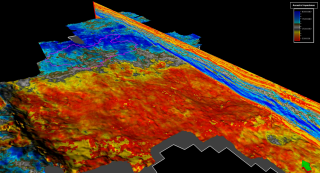
Central Basin Platform to Midland Basin area showing basin infill patterns in the form of San Andres; Grayburg forced regressive clinoform ooid grainstone depositions.
- Building the BEG’s first regional geomodels of the main North American unconventional reservoir plays, including the Bakken, Barnett, Haynesville, Fayetteville, and Marcellus shale basins for Dr. Scott Tinker’s BEG Shale Play Study Research Team.
- Creating the BEG’s first regional geomodels of the Midland Basin and Delaware Basin.
- Creating a regional geomodel of the Eagle Ford & Austin Chalk formations in the Gulf Coast region.
- Collaborating with Charles Kerans on the Fasken Ranch shelf-to-basin 3D model of the Wolfcampian-Leonardian-Guadalupian successions.
- Collaborating with Steve Ruppel on a detailed stratigraphic reservoir model of the Delaware Basin Wolfcamp.
- Providing knowledge transfer opportunities to the industry by teaching short courses with Charles Kerans about 3D integrated carbonate reservoir characterization and geomodeling.

