
Feedbacks between surface deformation and permafrost degradation in ice wedge polygons, Arctic Coastal Plain, Alaska
Charles J. Abolt, Michael H. Young, Adam L. Atchley, Dylan R. Harp, and Ethan T. Coon
Journal of Geophysical Research: Earth Surface, v. 125, no. 3, article no. e2019JF005349. https://doi.org/10.1029/2019JF005349
Study Summary
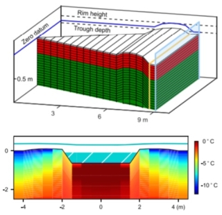
In the past three decades, an abrupt acceleration of ice wedge melting has transformed tundra landscapes across the Arctic, creating hummock‐like features known as high‐centered polygons (HCPs). This rapid geomorphic transition profoundly alters regional hydrology and influences surface emissions of carbon dioxide and methane. In northern Alaska, most recent instances of ice wedge degradation have slowed or stopped within 15–20 years of inception, stabilizing the HCPs. However, feedbacks between ground surface deformation and permafrost stability are not well understood, limiting our ability to predict how landscape evolution will occur in a still warmer future. In this research, we use field data from a site approximately 60 km south of Prudhoe Bay, Alaska, to assess the strength of positive (i.e., exacerbating) feedbacks on ice wedge degradation by developing a modeling‐based framework. We focus on the importance of heterogeneity in surface drainage and microtopographic conditions. Our results suggest that when troughs are narrow, positive feedbacks on ice wedge melting are relatively weak, but they are much stronger beneath wide troughs, such as those that form above older, larger ice wedges. Seasonal thaw accelerates if an area of soil begins to thaw (known as a talik) beneath wide and deep thermokarst pools. If taliks do form, winter severity and snowpack thickness become more important as predictors of summertime thaw. Our results indicate that meter‐scale heterogeneity in polygonal microtopography can exert strong, nonlinear controls on thermokarst trajectories.
Why is this research important and why do the results matter?
- Significant amounts of soil organic carbon are stored in frozen soil in Arctic regions. Measurements have shown that this area is warming faster than other regions across the globe, potentially thawing and releasing this stored carbon into the atmosphere.
- We have only a partial understanding of the processes under which these soils thaw and create the ice wedge polygons found throughout Arctic regions. This study sought to develop a conceptual model of how these soils thaw and how topography changes.
- These findings are useful for predicting future thermokarst dynamics and for interpreting the results from coarser‐resolution land surface models operating at greater spatial and temporal scales.

