
Summary:
The Upper Jurassic (Kimmeridgian to Lower Tithonian) Haynesville and Bossier Shales of East Texas and northwest Louisiana are currently one of the most important shale-gas plays in North America, having high IPs, steep decline rates, EURs estimated at 3 to 7 Bcf per well of each formation, and play resources estimated together in the hundreds of trillions of cubic feet (Fig. 1). Recently, Haynesville production of 5.62 BCFD (including Louisiana) surpassed Barnett production (5.4 BCFD). Shale thicknesses range from 200 to 350 feet at producing depths of 10-14,000ft+. The STARR team focuses on studies of Haynesville and Bossier Shale facies, deposition, geochemistry, petrophysics, production, pore evolution, and stratigraphy in light of paleogeographic setting and regional tectonics using wireline logs, seismic, and cores. Haynesville and Bossier depositional areas are characterized by different mudrock lithologies. Mudrocks range from calcareous-dominated facies near the carbonate platforms and islands to siliceous-dominated lithologies in areas where deltas prograded into the basin and diluted organic matter (e.g., northern Louisiana and northeast Texas; Fig. 1). Porosity occurs in nano-pores as interparticle pores and within organics. The mudrocks contain a complex mineralogical framework of carbonate, quartz, and clay (Fig. 2). Other important constituents are organics (TOC 2-6%), calcareous bioclasts, and pyrite in various forms. Sedimentological structures include burrowing, ripples, laminations, and current laminations related to turbidites (Fig. 3). Haynesville and Bossier gas shales are distinctive on wireline logs—high gamma ray, low density, low neutron porosity, high sonic travel time, moderately high resistivity.
Counties: Panola, Harrison, Rusk, Shelby, San Augustine, Sabine, Gregg, Marion, Upshur, Nacogdoches.
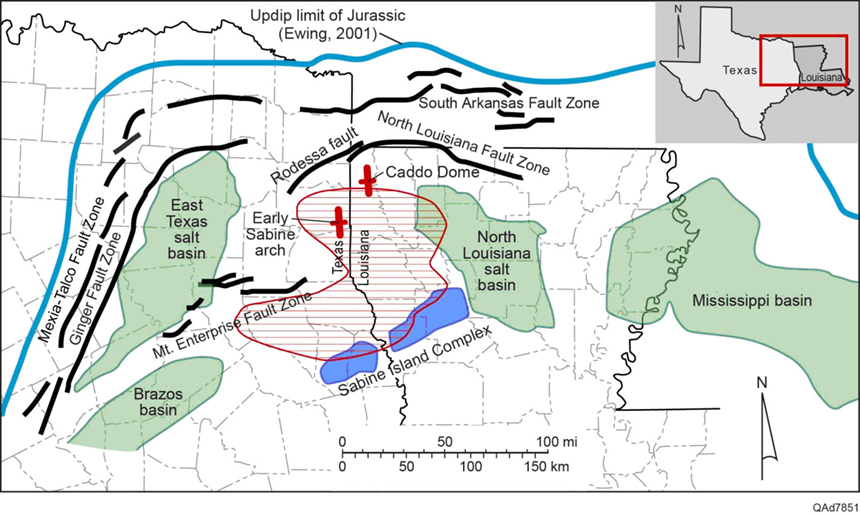
Figure 1: Study area and structural controls of the Upper Jurassic northeastern Gulf of Mexico basin. Shaded area represents productive Haynesville gas shale. Basins colored in green; uplifts colored in red.
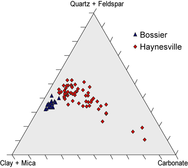
Figure 2: Ternary diagram showing Bossier and Haynesville mineralogical data from x-ray diffraction analyses. Haynesville mudstones contain abundant carbonate, whereas Bossier mudstones are dominantly clay and quartz, indicating a shift from transgressive carbonate-dominated environment to progradation of clastics due to highstand deposition in the Bossier.
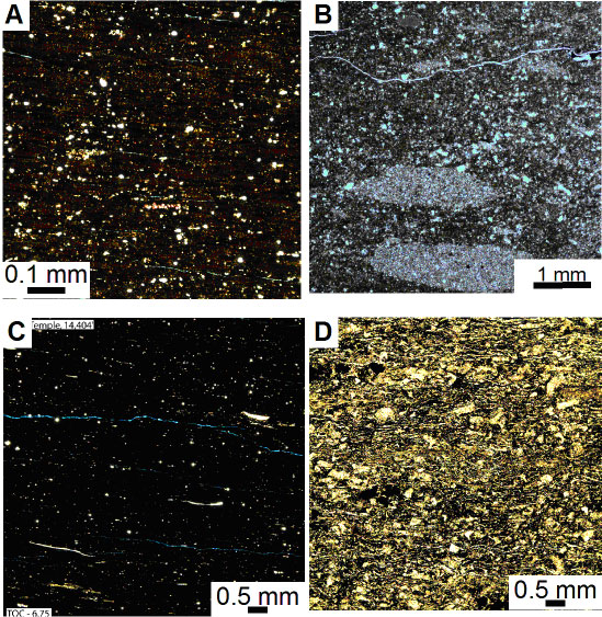
Figure 3: A Haynesville unlaminated mudstone facies showing silt-sized siliceous and carbonate grains, pelleted matrix, and organics (brown). B. Haynesville burrowed mudstone facies showing carbonate and siliceous grains, peloids, and burrows filled with calcite (B). C. Organic-rich Bossier unlaminated mudstone facies showing fillibranch mollusks and silt-sized siliceous and calcareous grains. D. Bioturbated calcareous mudstone showing abundant calcitic bioclasts in organic-rich matrix. Haynesville samples are from Louisiana and East Texas. Bossier samples are from the Shell Temple and Jones cores of Sabine Island, Texas.

