
Recent Geologic Hazard Studies at the Wink Sinkholes
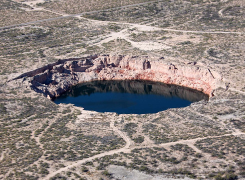
Figure 1. View of Wink Sink 2 taken from the southwest in November 2013. The diameter of the sinkhole is approximately 200 m. Photograph by Aaron Averett.
Two large sinkholes formed near the West Texas communities of Wink and Kermit in 1980 (Wink Sink 1) and 2002 (Wink Sink 2). Bureau researchers began studying these features after the collapse of Wink Sink 1 and have continued work in the area since then. After Wink Sink 2 collapsed, Bureau researchers have employed multiple remote sensing, geophysical, and geological approaches to better understand sinkhole collapse and delineate areas of historical and ongoing subsidence to assess the potential for future sinkhole formation.
Episodic sinkhole collapse affects many parts of Texas. The classic examples of sinkhole formation near Wink can be studied to anticipate future events there and to employ new approaches to sinkhole monitoring and risk assessment there and elsewhere.
Many of the assessment and monitoring approaches being applied to the Wink sinkhole area are equally applicable to the study of other sinkhole-prone areas in Texas and elsewhere. As new geophysical and remote-sensing techniques become available, results from the application of these new methods at Wink will augment the long-term studies already completed, allowing researchers and public officials to better understand the ongoing risk to citizens and public and private infrastructure posed by sudden sinkhole collapse and chronic ground subsidence.
Bureau researchers and collaborators are employing (1) satellite-based radar interferometry to monitor ground subsidence over months to years, (2) airborne lidar surveys to establish baseline ground elevations and quantify historical elevation change over decades, (3) geodetic-quality GPS surveys to measure site-specific elevation change, and (4) microgravity surveys in key areas to identify the locations of shallow mass deficits possibly signifying areas where continued subsidence or sudden collapse could occur.
Numerous articles and reports on the Wink sinkholes have been written and published by Bureau staff. Results of the latest work at Wink are routinely presented at public meetings and at professional conferences. Some of the latest work is highlighted at https://www.beg.utexas.edu/research/programs/near-surface-observatory/wink-sink.
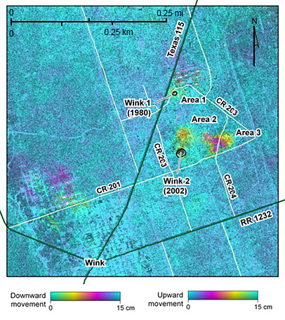
Figure 2. Initial 6-month interferogram showing areas undergoing subsidence (downward movement away from the satellite). Interferogram constructed by researchers from the UT Center for Space Research from ALOS synthetic aperture radar data acquired in 2007.
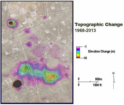
Figure 3. Topographic change measured in the Wink sinkholes area by comparing an airborne lidar-derived DEM (November 2013) with USGS topographic data from the 1960’s. Wink Sink 1 is evident at the upper left and Wink Sink 2 at the lower left of the image.
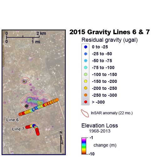
Figure 4. Local gravity anomalies measured near Wink Sink 2 during a 2015 microgravity survey along county and lease roads. Local gravity lows coincide with areas undergoing subsidence as determined from satellite InSAR data acquired between January 2007 and November 2008.
Name of project: Wink Sinkholes
Name of research program or IA: Near Surface Observatory
Date of project start (if applicable): 1980’s
Term of project (if applicable): Ongoing
Project PI(s): Jeffrey G. Paine
Other key personnel: Edward W. Collins, John Andrews, Kutalmis Saylam, Robert Baumgardner
Principal information contact: Jeffrey G. Paine
Funding source(s): Industry donations, STARR Hazards (State of Texas)
Geographic area(s) of study: Winkler County, West Texas
General discipline of study: Geology, geophysics, remote sensing
Keywords: Geologic hazards, sinkholes, subsidence, collapse, microgravity, lidar, InSAR

