
Focused and Preferential Flow in Unsaturated Media
Focused Recharge Beneath Ephemeral Lakes (Playas) in the Southern High Plains, Texas
Bridget Scanlon, Principal Investigator (March 2006)
We quantified unsaturated flow beneath playa and adjacent interplaya settings at a site in the Southern High Plains (United States) to resolve issues related to where and how water moves through the unsaturated zone. This is the first study in which the data density (39 boreholes) and the variety of techniques used (physical, chemical, and isotopic) were sufficient to quantify spatial variability in unsaturated flow. Water contents, water potentials, and tritium concentrations were much higher and chloride concentrations were much lower beneath playas than in interplaya settings, which indicated that playas focus recharge. These results refute previous hypotheses that playas act as evaporation pans or that recharge is restricted to the annular region around playas. Water fluxes estimated from environmental tracers ranged from 60 to 120 mm yr 2 1 beneath playas and were #0.1 mm yr 2 1 during the past 2000–5000 years beneath natural interplaya areas not subjected to ponding. To evaluate the apparent inconsistency between high recharge rates and thick clay layers beneath playas, we applied bromide and FD&C blue dye to evaluate flow processes. These applied tracer experiments showed preferential flow along roots and desiccation cracks through structured clays in the shallow subsurface in playas.
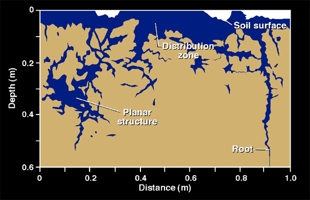
FD&C Blue dye test showing preferential flow paths beneath a playa related to root tubules and interped surfaces in these structured, clay rich soils.
Focused Flow in Fissured Sediments in the Chihuahuan Desert
Bridget Scanlon, Principal Investigator (March 2006)
Localized flow beneath fissures in arid settings has important implications for waste disposal in these regions. Fissures are surface features or gullies that are underlain by sediment filled fractures. The objectives of this study were to compare unsaturated flow beneath different fissures, investigate the vertical and lateral extent of increased flow associated with fissures, and examine different techniques for evaluating flow in zones containing fissures. Boreholes were drilled directly beneath four Fissures and at horizontal distances of 10 and 50 m from the fissures. Physical parameters such as water content and water potential were analyzed in sediment samples and water potential was analyzed in plant samples. Environmental tracers such as Cl, Cl-36/Cl, H-3, D, and O-18 were analyzed in sediment samples. A trench was dug beneath one fissure for detailed sampling. Electromagnetic induction was used to measure apparent electrical conductivity in transects perpendicular to the fissures. Unsaturated flow is relatively higher beneath fissures, as evidenced by higher water potentials and lower chloride concentrations there than in surrounding sediments. The lateral extent of high water flux was restricted to the zone directly beneath one fissure but extended to profiles 10 m from two other fissures. The profiles 50 m from all fissures had low water fluxes, as indicated by low water potentials and high maximum chloride concentrations, the vertical extent of high water fluxes was restricted to the upper 10 to 20 m zone, as shown by water potential and chloride fronts within the upper IO m zone beneath one fissure and by chloride fronts in the upper 20 m zone beneath and 10 m from another fissure. Additional evidence for localized water Bur was provided by less enriched D and O-18, and higher plant water potentials in sediments beneath fissures relative to sediments adjacent to fissures. High tritium levels were found in all sampled profiles and cannot readily he explained. Apparent electrical conductivity was higher in two of the four fissures, Multiple independent lines of evidence indicate that subsurface water fluxes are higher at shallow depths beneath fissures; however, the various techniques differ in their effectiveness in delineating higher water fluxes beneath fissures. Multiple profiles drilled in one fissure indicate that there is large variability in flow along this fissure that is attributed to topographic variations and degree of pending.
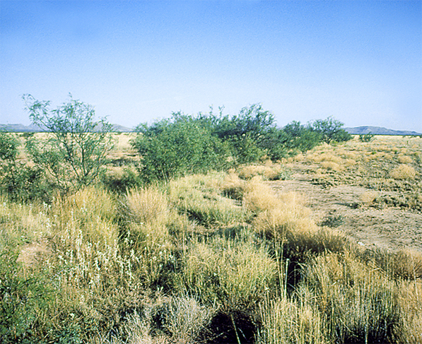
Figure 1. Concentration of vegetation along fissure reflecting opportunistic behavior of vegetation for using excess soil moisture in this water limited ecosystem.
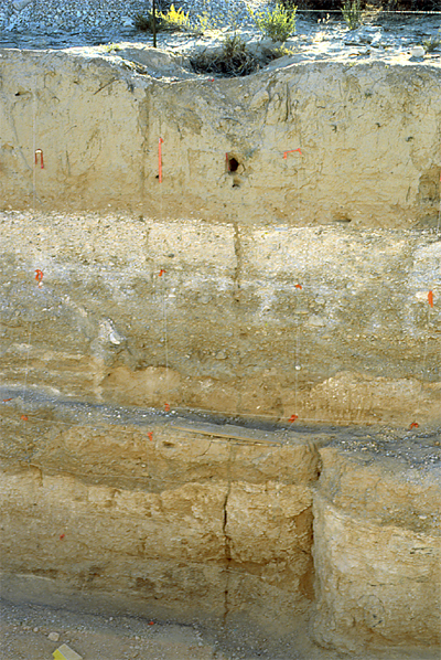
Figure 2. Gully at the surface reflecting location of fissure underlain by fracture that extends to at least 6 m.

