
Climate Variability and Climate Change Studies
Impact of ENSO on Groundwater Recharge in the Southwestern U.S.
Bridget Scanlon, Principal Investigator (March 2006)
The impact of climate variability on the water cycle in desert ecosystems is controlled by biospheric feedback at interannual to millennial timescales. This paper describes a unique field dataset from weighing lysimeters beneath nonvegetated and vegetated systems that unequivocally demonstrates the role of vegetation dynamics in controlling water cycle response to interannual climate variability related to El Nino southern oscillation in the Mojave Desert. Extreme El Nino winter precipitation (2.3–2.5 times normal) typical of the southwestern U.S. would be expected to increase groundwater recharge, which is critical for water resources in semiarid and arid regions. However, lysimeter data indicate that rapid increases in vegetation productivity in response to elevated winter precipitation reduced soil water storage to half of that in a nonvegetated lysimeter, thereby precluding deep drainage below the root zone that would otherwise result in groundwater recharge. Vegetation dynamics have been controlling the water cycle in interdrainage desert areas throughout the southwestern U.S., maintaining dry soil conditions and upward soil water flow since the last glacial period (10,000–15,000 yr ago), as shown by soil water chloride accumulations. Although measurements are specific to the southwestern U.S., correlations between satellite-based vegetation productivity and elevated precipitation related to El Nino southern oscillation indicate this model may be applicable to desert basins globally. Understanding the two-way coupling between vegetation dynamics and the water cycle is critical for predicting how climate variability influences hydrology and water resources in water-limited landscapes.
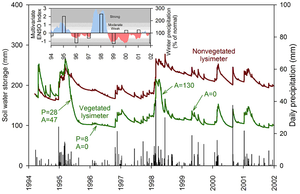
Measured soil water storage to a depth of 2m in both vegetated and nonvegetated lysimeters and daily precipitation depths at the NTS location. Above-ground biomass productivity (g/m2) is shown for measurements in May 1995 and May 1996 for annual and perennial vegetation at the nearby Yucca Mountain site and May 1998 and May 1999 for annual vegetation at the nearby free air CO2 experiment site. (Inset) Relationship between the multivariate ENSO index (blue shading; El Nino, red shading; La Nina) and percent of normal 1971–2000 winter precipitation (normal, 46 mm, December–February; columns) at the NTS location.
Reference
Scanlon, B. R., Levitt, D. G., Keese, K. E., Reedy, R. C., and Sully, M. J., 2005, Ecological controls on water-cycle response to climate variability in deserts. Proceedings of the National Academy of Sciences of the United States of America 102:6033–6038.
Variations in Flow and Transport in Thick Desert Vadose Zones in Response to Paleoclimatic Forcing (0–90 kyr): Field Measurements, Modeling, and Uncertainties
Bridget Scanlon, Principal Investigator (March 2006)
An understanding of unsaturated flow and potential recharge in interdrainage semiarid and arid regions is critical for quantification of water resources and contaminant transport. We evaluated system response to paleoclimatic forcing using water-potential and Cl profiles and modeling of nonisothermal liquid and vapor flow and Cl transport at semiarid (High Plains, Texas) and arid (Chihuahuan Desert, Texas; Amargosa Desert, Nevada) sites. Infiltration in response to current climatic forcing is restricted to the shallow (~ 0.3–3 m) subsurface. Subsurface Cl accumulations correspond to time periods of 9 to 90 kyr. Bulge-shaped Cl profiles generally represent accumulation during the Holocene (9–16 kyr). Lower Cl concentrations at depth reflect higher water fluxes (0.04–8.4 mm/yr) during the Pleistocene and earlier times. Low water potentials and upward gradients indicate current drying conditions. Nonisothermal liquid and vapor flow simulations indicate that upward flow for at least 1 to 2 kyr in the High Plains and for 12 to 16 kyr at the Chihuahuan and Amargosa desert sites is required to reproduce measured upward water potential gradients and that recharge is negligible (< 0.1 mm/yr) in these interdrainage areas.
Temporal variability in water potential monitored in situ at various depths in the Hueco Bolson, Chihuahuan Desert. Wetting is restricted to the upper 0.8 m in 1992 in response to elevated precipitation in this sandy site covered with creosote bushes. Daily precipitation is also shown.

