
Shoreline Movement in the Copano, San Antonio, and Matagorda Bay Systems, Central Texas Coast, 1930s to 2010s
Project Team: Jeffrey G. Paine, Principal Investigator; Tiffany Caudle, John Andrews, Aaron Averett, John Hupp, Kutalmis Saylam, and Rebecca Brown
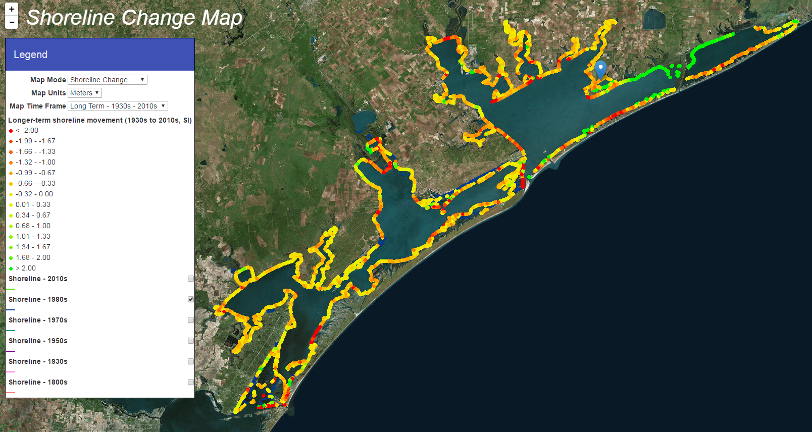
Online Viewer
View long-term and more recent shoreline change, shoreline types, and erosion susceptibility in the Copano, San Antonio, and Matagorda Bay systems using the interactive, online viewer.
Summary
Shoreline position and morphology extracted from airborne lidar surveys acquired over the Copano, San Antonio, and Matagorda Bay systems (Figure 1) between 2013 and 2015 were used to (1) classify 1,065 km of bay shoreline into 11 common shoreline types, and (2) compare shoreline positions extracted from lidar survey data with previous shoreline positions determined from aerial photographs from the 1930s, 1950s, and 1982 to determine shoreline-movement and land-loss rates for a long-term (1930s to 2010s) and more recent (1950s or 1982 to 2010s) period. From higher to lower elevation adjacent to the shoreline, the common shoreline types are high and low Pleistocene clayey sand and sandy clay bluffs, Pleistocene sandy slopes, fan deltas, sandy and shelly beaches and spits, tidal passes, flood-tidal delta marshes and tidal flats, deltaic marshes, and back-barrier and bay-margin marshes and tidal flats (Figure 2). The lower-elevation shoreline types (back-barrier and bay-margin marsh and tidal flats) are the most common shoreline types in the three bay systems, together constituting about 50 percent of the total shoreline length.
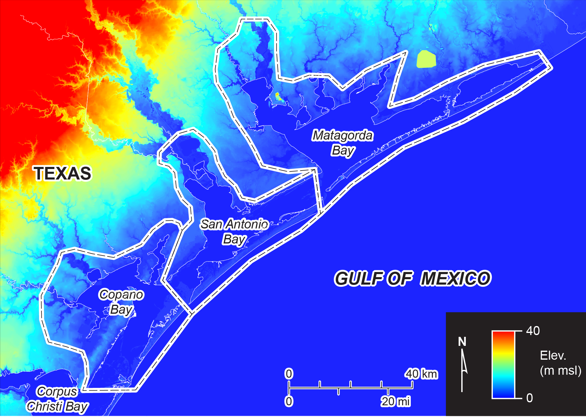
Figure 1. Boundaries of the Copano Bay, San Antonio Bay, and Matagorda Bay systems superimposed on a topographic map of the central Texas coast. Regional topographic data from the U. S. Geological Survey.
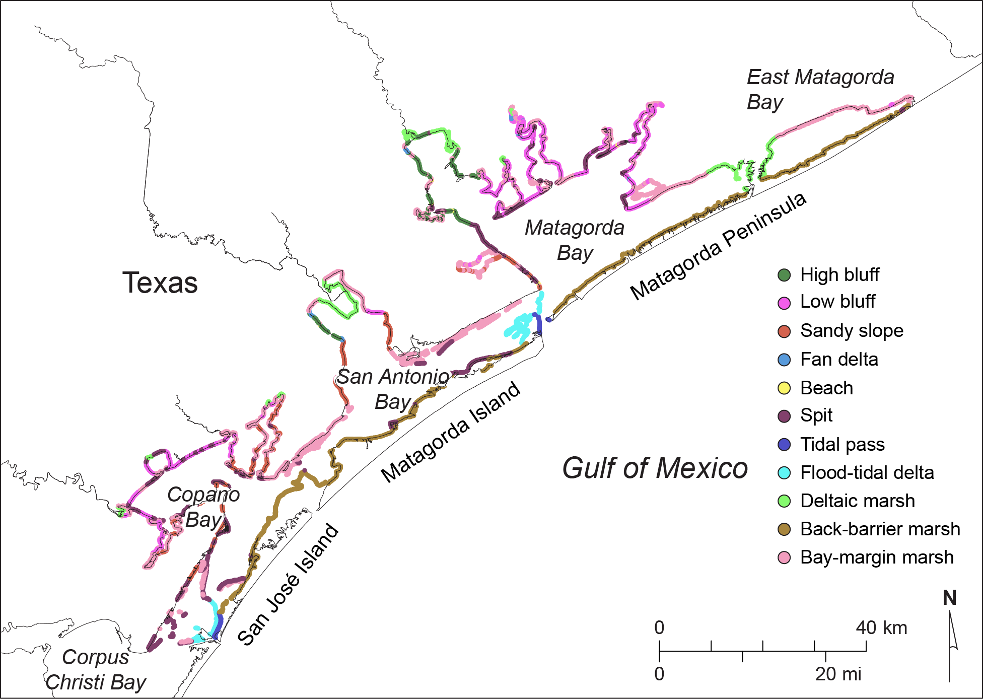
Figure 2. Distribution of principal shoreline types (table 3) in the Copano, San Antonio, and Matagorda Bay systems.
Shoreline movement was dominantly erosional over both the long-term and more recent periods, with 80 percent of the nearly 10,000 measurement sites retreating between the 1930s and 2010s (Figures 3 and 4) and 82 percent retreating during the more recent period. Despite the preponderance of sites undergoing shoreline retreat, the net shoreline movement rate for the long-term period was nearly zero because ubiquitous erosion in the Copano, San Antonio, and Matagorda Bay systems was offset by delta progradation across eastern Matagorda Bay when a river logjam on the Colorado River was removed in 1929. During the more recent period, net shoreline retreat averaged -0.60 m/yr for all bay systems, translating to an average land-loss rate of 63.5 ha/yr. Average shoreline retreat rates were highest in Matagorda Bay at -0.64 m/yr, followed by Copano Bay retreat rates at -0.62 m/yr and San Antonio Bay retreat rates at -0.49 m/yr. Shoreline types experiencing the highest rates of retreat between the 1930s and 2010s were the tidal pass (-0.79 m/yr), sandy and shelly spit (-0.72 m/yr), and high bluff (-0.54 m/yr) shorelines (Figure 5). During the more recent period, shoreline retreat rates increased for all shoreline types. Shorelines retreated most rapidly along tidal passes (-1.67 m/yr), high bluffs (-0.86 m/yr), and spits (-0.84 m/yr) during the most recent period.
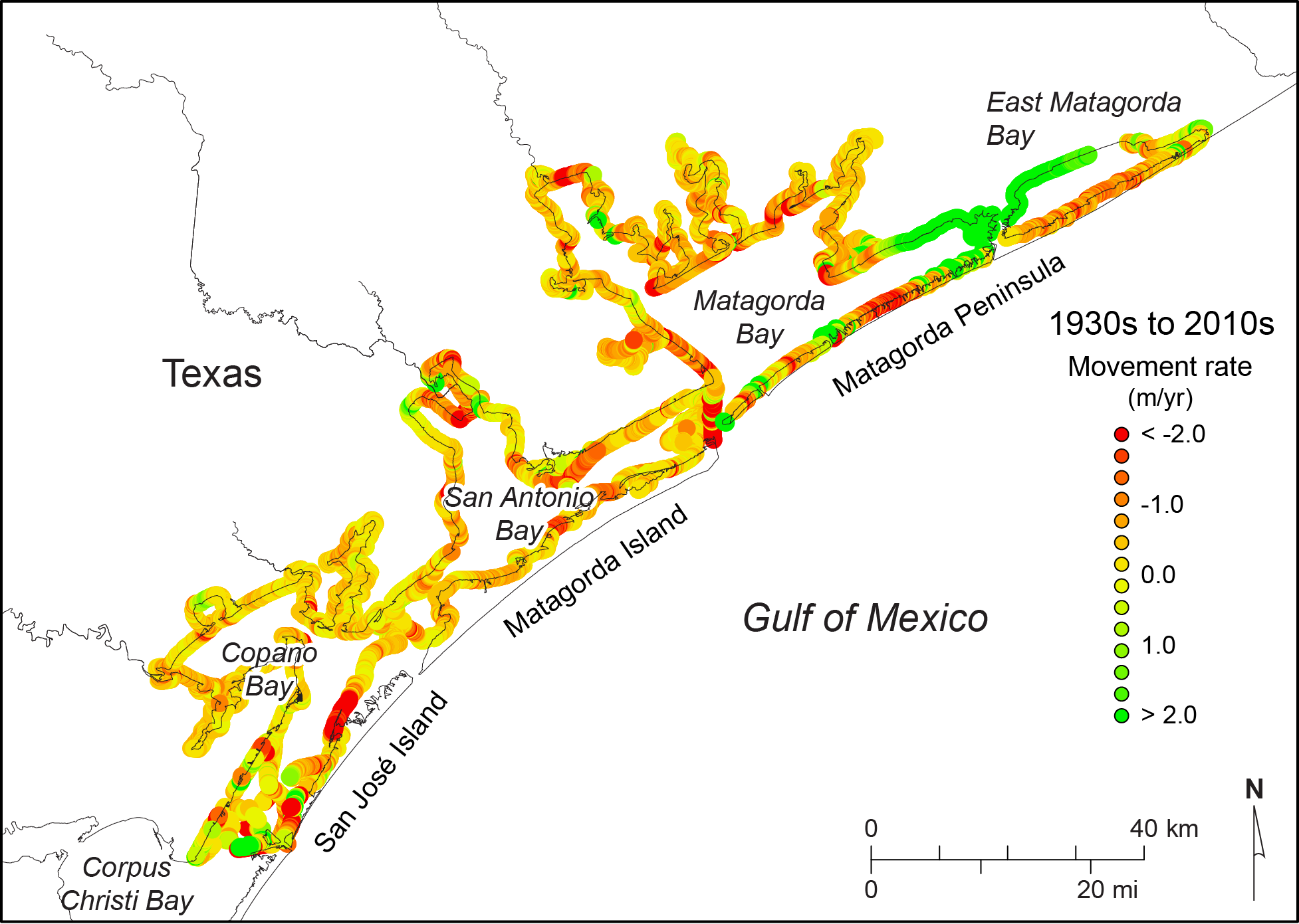
Figure 3. Net long-term (1930s to 2010s) shoreline movement rates in the Copano, San Antonio, and Matagorda Bay systems, central Texas coast.
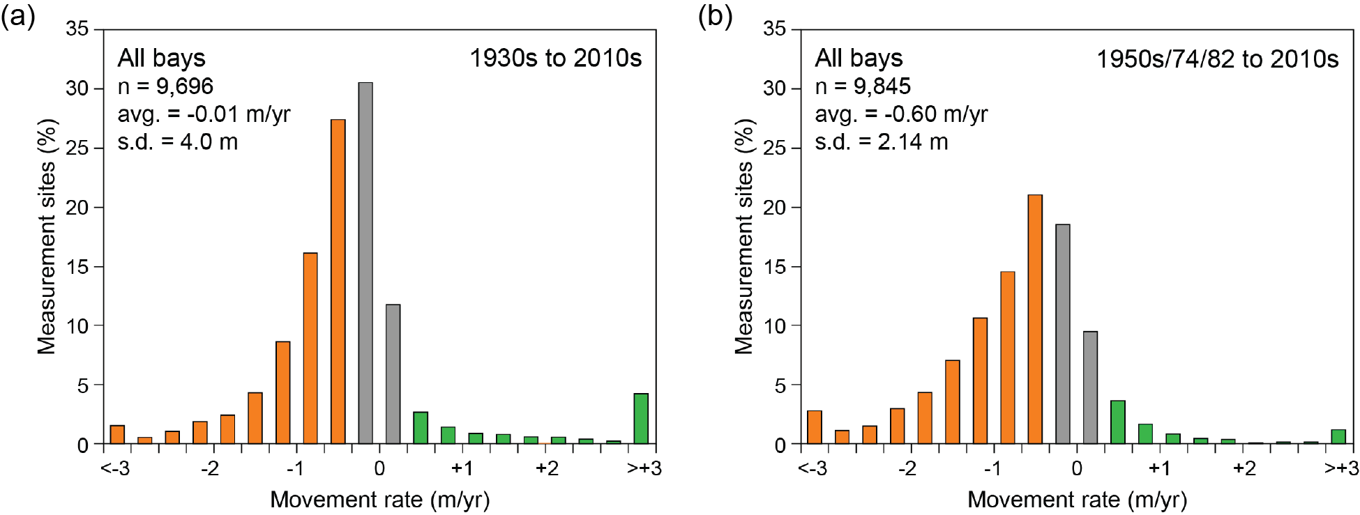
Figure 4. Distribution of longer-term (1930s to 2010s, left column) and more recent (1950s, 1974, or 1982 to 2010s, right column) shoreline movement rates in central Texas coastal bay systems (Copano, San Antonio, and Matagorda Bay systems combined).
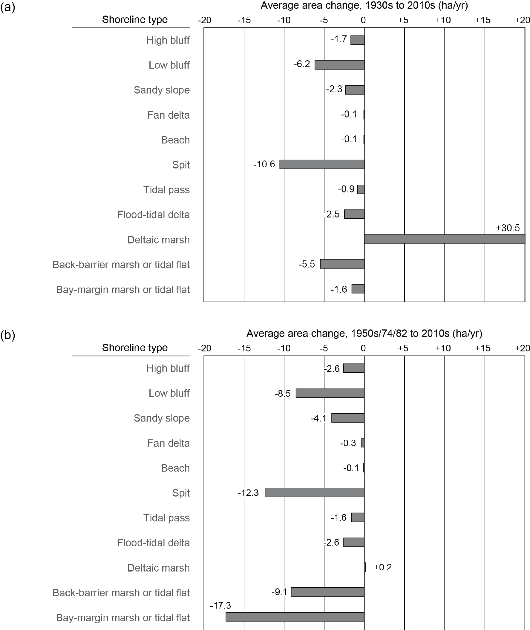
Figure 5. Average (a) long-term (1930s to 2010s) and (b) more recent (1950s/74/82 to 2010s) area change rate for common bay shoreline types in the Copano, San Antonio, and Matagorda Bay systems.
Shoreline type properties were used to assess the erosion susceptibility of each type to relative sea-level rise (Figure 6), storm surge and storm-wave action (Figure 7), and normal wave action (Figure 8) according to a low‑, moderate-, and high-susceptibility scale. Shorelines along most low-elevation shores, including deltaic marshes and back-barrier and bay-margin marshes and tidal flats, are highly susceptible to relative sea-level rise and non-storm wave action, but generally less susceptible to storm surge and waves. Like other low-elevation shoreline types, shorelines along tidal passes and flood-tidal deltas are highly susceptible to retreat caused by relative-sea-level rise and non-storm waves, but are also highly susceptible to retreat caused by flood and ebb currents associated with storm surge. Slightly higher fan delta, beach, and spit shores are highly susceptible to shoreline retreat caused by non-storm wave action and are moderately susceptible to shoreline retreat related to relative sea-level rise and storm surge and waves. Shorelines that front high and low Pleistocene bluffs and sandy slopes are highly susceptible to retreat caused by storm waves elevated by storm surge during tropical cyclone passage and are moderately susceptible to retreat caused by normal wave action, but are relatively insensitive to relative sea-level rise.
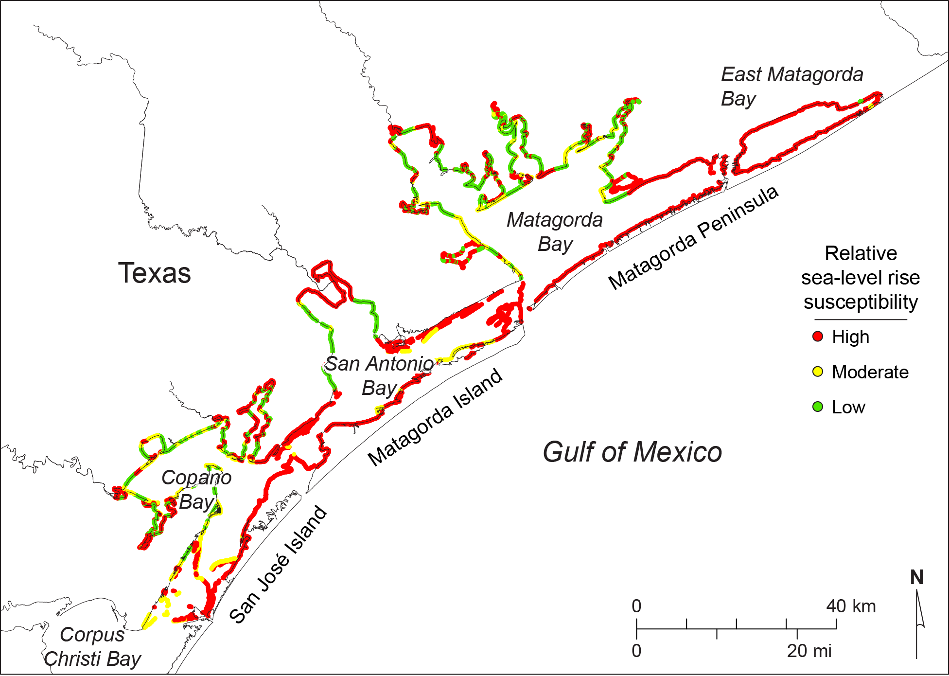
Figure 6. Shoreline types classified by susceptibility to retreat associated with relative sea-level rise.
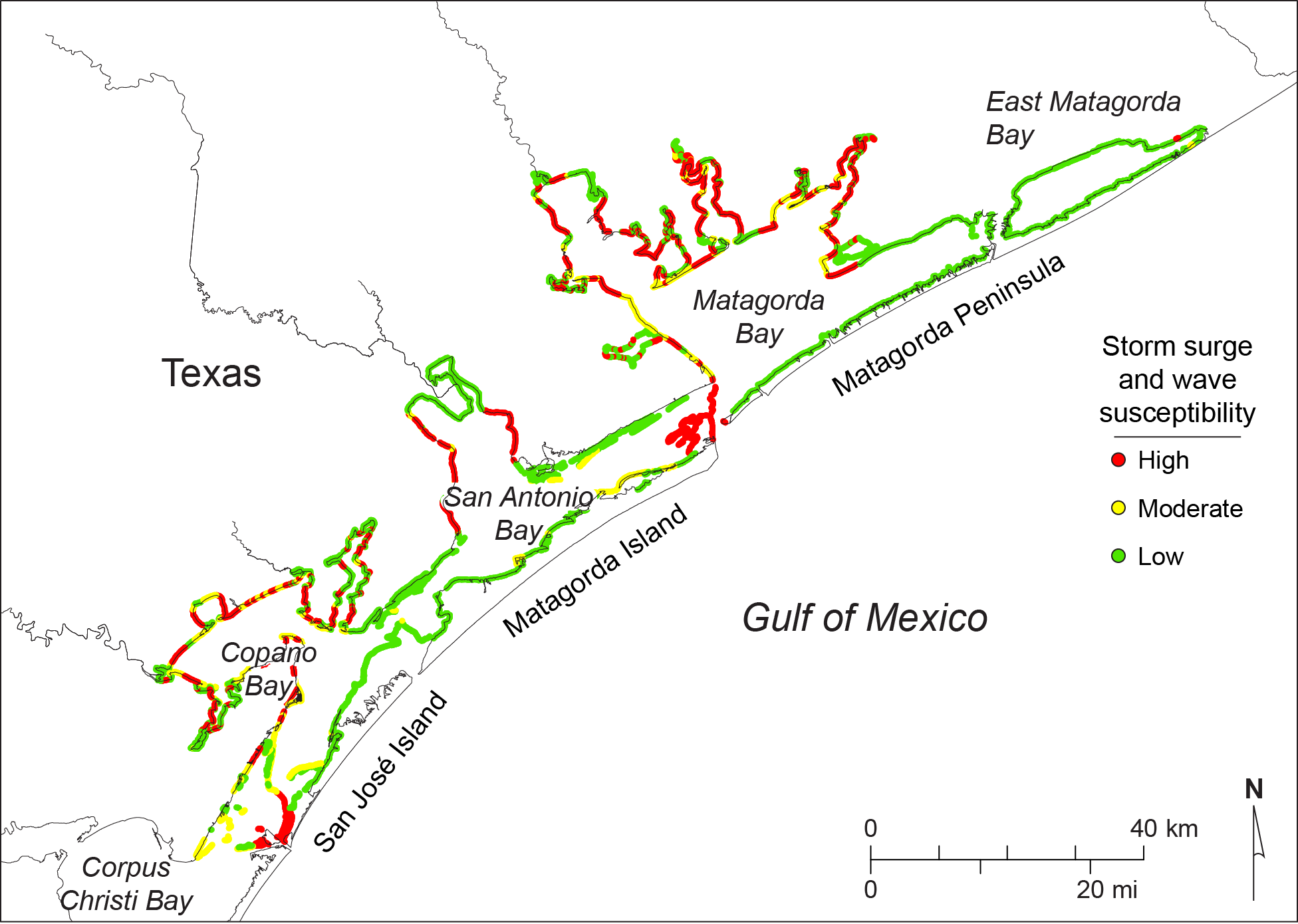
Figure 7. Shoreline types classified by susceptibility to erosion associated with storm surge and storm wave action.
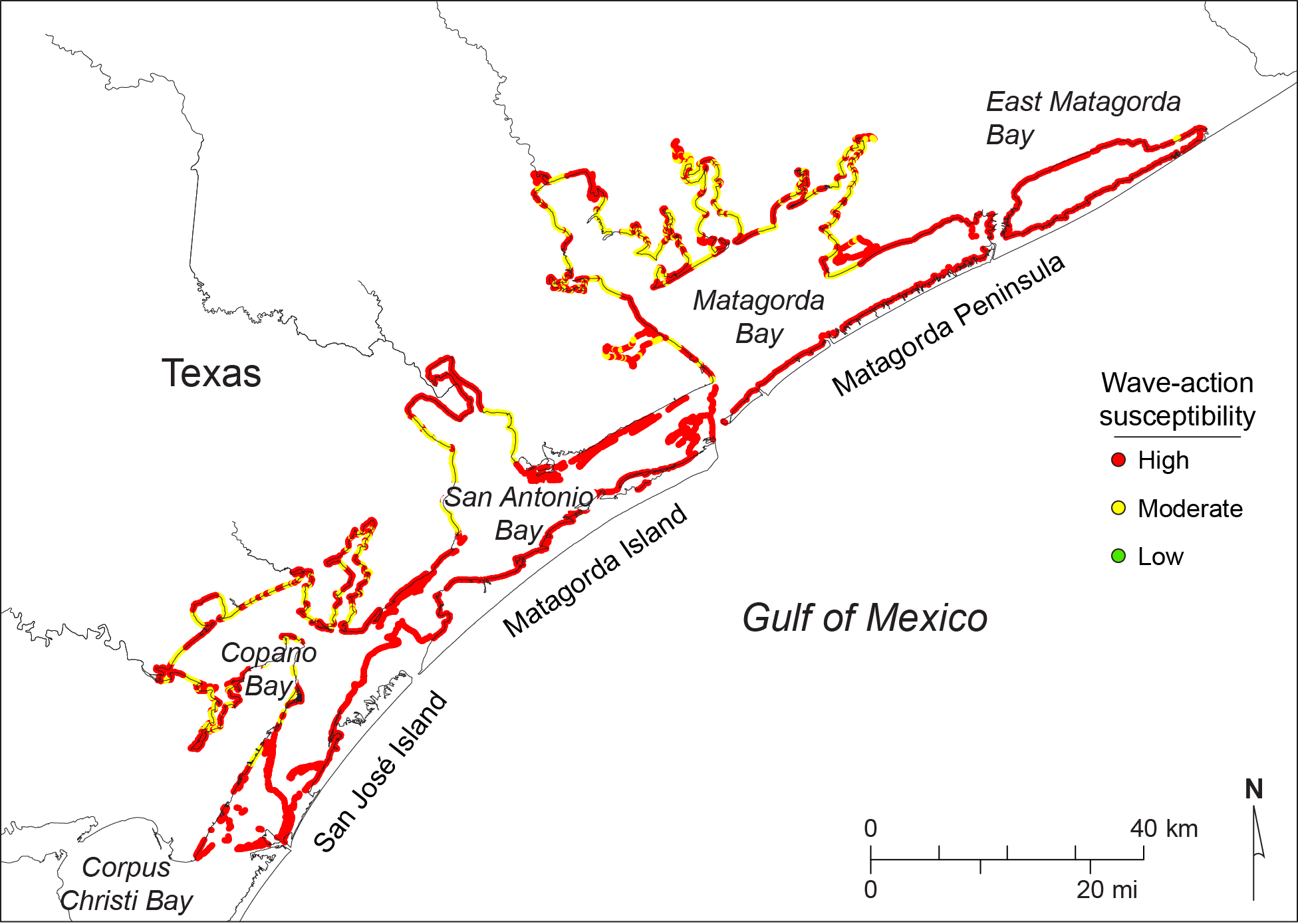
Figure 8. Shoreline types classified by susceptibility to retreat associated with wave action.
Acknowledgments
This project was supported in part by a financial assistance award from the U.S. Department of the Interior, U.S. Fish and Wildlife Service, Coastal Impact Assistance Program under CIAP award no. F12AF01039. The award was administered through grant no. 13-258-000-7485 from the General Land Office of Texas to the Bureau of Economic Geology, The University of Texas at Austin. Carly Vaughn and Carla Kartman (General Land Office) served as project managers. Thomas R. Calnan (U.S. Fish and Wildlife Service) served as project liaison. Jeffrey G. Paine and Tiffany Caudle (BEG) served as the principal and co-principal investigators. The views and conclusions contained in this document are those of the authors and should not be interpreted as representing the opinions or policies of the U.S. Government or the State of Texas. Mention of trade names or commercial products does not constitute their endorsement by the U.S. Government or the State of Texas.
Results of this project are discussed in a comprehensive report cited as:
Paine, J. G., Caudle, T., and Andrews, J. R., 2016, Shoreline movement in the Copano, San Antonio, and Matagorda Bay systems, central Texas coast, 1930s to 2010s: Bureau of Economic Geology, The University of Texas at Austin, Final Report prepared for General Land Office under contract no. 13-258-000-7485, 72 p.

