
The Kinematics of Meandering Channels
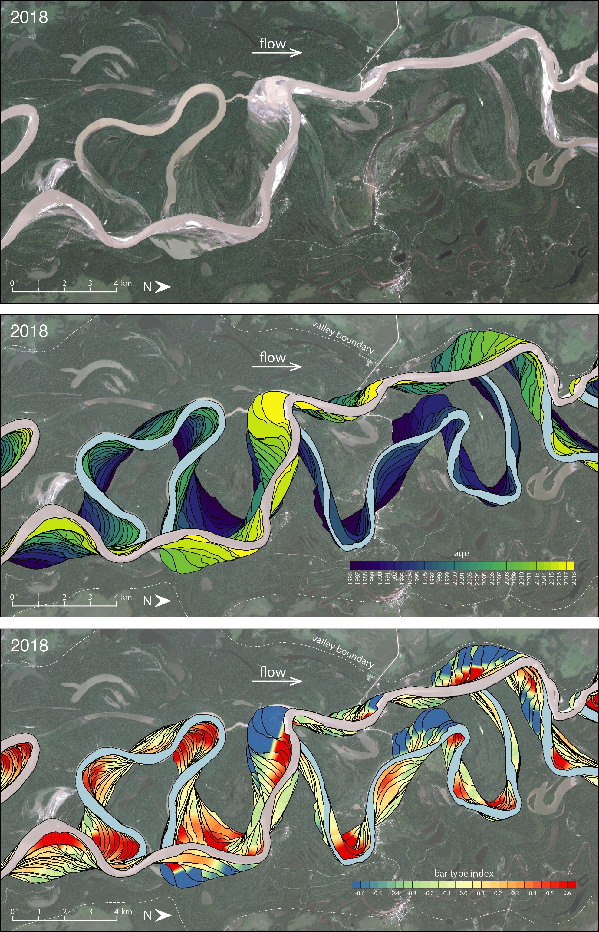
Temporal evolution (middle panel) and location of counter point bars, as suggested by the bar type index (lower panel) along a segment of the Mamoré River, Bolivia. Satellite image (upper panel) courtesy of Planet Labs, Inc.
An important idea about the geomorphology of meandering rivers is that erosion and deposition rates along the banks are a nonlinear function of curvature, largely due to the complicated hydrodynamics of sharp bends. However, the datasets that have been collected to test these ideas are limited in size and resolution. This project focuses on addressing a question with a potentially valuable answer: Can simple kinematic models of meandering—which assume a close-to-linear relationship between curvature and erosion/deposition (or migration rate)—explain a significant part of the migration observed in time-lapse satellite imagery and other kinds of remote sensing data? And if so, what are the implications for predicting channel migration and the nature of the resulting deposits? As meandering rivers and their deposits are common along many passive continental margins (e.g., the Gulf coast), improved predictions of river migration have implications for designing and protecting infrastructure, agricultural land management, and development of riparian vegetation. In addition, the geometry of the banks and the speed of migration have a strong impact on the grain size and heterogeneity of the deposits the river leaves behind; these heterogeneities influence fluid flow in the sediment, with implications for managing subsurface energy and water resources and designing carbon sequestration projects.
As a first phase of the project, we have performed high-resolution measurements of migration rates of more than 1,600 bends in time-lapse Landsat satellite images, covering more than 4,000 kilometers (2,485 miles) of 7 rapidly migrating meandering rivers in the Amazon Basin. The results suggest that the variation of migration rate closely follows that of the local channel curvature. However, locations of maximum migration rate are shifted downstream relative to peak curvature, with a phase lag that shows limited variability for the same river segment. A quasi-linear relationship between the two emerges when this lag is accounted for. Overall, bends with the highest curvatures show the highest migration rates; exceptions with limited migration seem to be related to the low erodibility of the outer bank, not the hydrodynamics of the flow. These results were published in 2019 in Geology.
A second phase of the project focuses on the link between this simple curvature–migration rate relationship and the development of counter point bars, deposits forming along concave banks of a river, in contrast with conventional point bars that result from deposition along convex banks. Counter point bars tend to be finer grained than the point bars in the same system; mud-rich deposits are not uncommon in such settings, without any tidal influence. Simple kinematic models suggest that counter point bars—and the associated downstream translation—are common in many meandering systems, and the probability of their occurrence can be quantified using a parameter called the bar type index.
Further information:
Jackson School of Geosciences press release
Animation of kinematic model concept
Preprint on counter point bars
Name of Project: The Kinematics of Meandering Channels: Implications for Deposit Heterogeneity
Name of Research Program or IA: Quantitative Clastics Laboratory
Project PI(s): Zoltan Sylvester
Other key personnel: students Cole Speed, Indre Altman, and Paul Morris; Bureau Research Scientist Jacob Covault
Principal information contact:
Zoltan Sylvester
zoltan.sylvester@beg.utexas.edu
Funding source(s): Sponsors of the Quantitative Clastics Laboratory industrial consortium
Other key (institutional or business) partners/collaborators: Paul Durkin (University of Manitoba, Canada); David Mohrig (Department of Geological Sciences, UT Austin); Steve Hubbard (University of Calgary, Canada)
Geographic area(s) of study: Amazon Basin, Texas coast, eastern Gulf of Mexico, Campos Basin
General discipline(s) of study: Geomorphology, sedimentology, stratigraphy, remote sensing
Keywords (for search returns): Meandering, rivers, submarine channels, sinuosity, point bars

