
The Bureau Explores Sand Resources
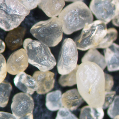
Rounded, relatively uniform grains like these from the Kermit sand are desirable for applications like fracking.
The Bureau of Economic Geology Economic Mineral Resource Program, in conjunction with the Bureau’s Center for Energy Economics, has recently established a research focus on sand resources that includes resource analysis, resource application, and sand logistics and transportation economics.
“Sand” really refers the size of the rock material, between 2mm and 0.0625mm, and can be composed of lots of different minerals. But, it is generally imagined that the material is mostly quartz. These grains can be angular or rounded, spherical or irregularly shaped, all the same size or a range of sizes, easily broken/crushed or very sturdy and resistant to crushing. There are a lot of factors and characteristics that affect how the sand behaves, and towards what application it is best suited.
One economically significant application of these mineral resources is the sand (proppant) used in fracking wells in the oil and gas industry. Fracking operations have seen a steady rise in the amount of sand used in each well, almost doubling in volume over the last 5 years. Sand used in hydraulic fracturing operations has very specific characteristics that industry has identified as favorable to propping open fractured formations in the subsurface and allowing oil and natural gas to flow more readily to extraction.
Every formation that contains oil and gas is different, with different rock type and different structural features at different depths that require engineers to make decisions on the sand specifications that are best suited at that particular well. The frac sand producers mine sand, crush the rock material if necessary, screen it to remove large particles, wash it to remove fine particles and dust, screen it into different size fractions, and dry it to remove any moisture.
Traditionally, the sand for proppant should be spherical to nearly spherical and non-angular, because this allows for tighter packing and more conductivity than non-spherical shaped grains, and angular grains tend to break and chip, creating fine particles that clog up pore spaces and inhibit conductivity (or the flow of oil and gas). One of the more important sand proppant properties is crush strength, where sand is tested in a lab to determine the pressure at which it starts to break down significantly. Shallower oil and gas formations require less pressure, and deeper formations require material that can withstand higher pressures. Very old sand (~500 million years old) that has been worked and re-worked, eroded and re-deposited, over and over again, tend to have all their edges rounded off, and tend to be very strong. Younger sands (< 2 million years old) may still be angular and more easily fractured under stress. The industry also creates ceramic sand sized particles that meet all of the proppant specifications and are very resistant to stress, but also more expensive than natural sand material.
Economically, transportation of sand to a wellsite is a majority of the cost, and the best, or most appropriate, sand may not be geographically located nearby. There are a lot of important decisions that have to be made that influence the economics of sand proppant choices and how it effects the eventual return on an operator’s investment with increased productivity of oil and gas at each individual wellsite.
The United States produced 95 million metric tons of industrial sand in 2015, more than half of the global sand production. The world’s second largest producer, Italy, produced only 14 million tons in the same year. 71% of the US tonnage was used as hydraulic fracturing sand and well-packing and cementing sand. The largest US sand producers, Wisconsin, Texas, Illinois, Minnesota, Missouri, Oklahoma, Arkansas, Ohio, North Carolina, and Louisiana, are fairly concentrated around the corridor from the Great Lakes region to Central Texas. It is estimated that transportation costs share 31 to 46 percent of the final landed cost of hydraulic fracturing sand. Central Texas’ sand resources located in close proximity to the hydraulic fracturing sites in the Eagle Ford Basin, Permian Basin, and Barnett Basin present an opportunity for minimizing transportation costs, and, therefore, the final cost of hydraulic fracturing. The opportunity is even more relevant now when oil producers are striving to reduce production costs.

Sand resource research leaders Brent Elliott of the Bureau's Economic Mineral Resource Program, and Michelle Foss of the Center for Energy Economics
The Bureau is engaged in geological mapping of sand resources, especially formations and units, like the Hickory sandstone of the Riley formation (see image below) , that produce much of the traditional frac sand from Central Texas. Bureau researchers evaluate the sand resource by calculating the volume and tonnage of sand reserve and overburden volume that will be removed to extract the resource in order to create an economic mineral resource model showing the economics of developing mineral extraction operations.
Part of a sand resource analysis includes the use of geospatial modeling techniques to map out the most favorable areas for exploration and resource extraction. Researchers determine where the sand is being transported, what kind of transportation infrastructure and possible pathways for transport (trucks, trains, barge, etc.) exist, distances of quarry operations to metropolitan areas that may require more resources as population grows, and other characteristics, like resource quality and stripping ratio, to build a combined map of new favorable sand mining sites across Texas.
The Bureau conducts research with a wide variety of databases related to subsurface geology, water resources, and oil and gas production, to identifying areas where sands with specific characteristics are most favorable for specific wellsite hydraulic fracturing conditions. Researchers locate regions with basin closure stress within the range of the compressibility strength of sand mined in Texas, and explore where other sand resources, from the northern Midwest for example, might be more suitable. The Bureau utilizes laboratory equipment to conduct testing (like crush strength, size distributions and grain analyses) on a wide variety of potential sand resources, exploring the characteristics and behavior of blended Texas sands and superior proppants like the Northern White Sand and synthetic proppants.
Transportation costs make up a majority of the expense in distributing sand for quarry operations to consumer site locations. The Bureau creates transportation models that integrate costs, distances, routing, trans-loading and other important factors to generate network datasets for all modes of transportation infrastructure in Texas, models costs of transportation, and calculates optimum routes using one or more modes of transportation. These models allow researchers to identify new infrastructure development opportunities and predict the impact of new transport infrastructure like railroads, highways, freight transfer stations, etc., near mining sites and hydraulic fracturing sites to explore the logistics and potential benefits for new infrastructure.
With sand resources playing a significant role in the extraction of hydrocarbons from the prolific shale and tight oil formations of Texas and elsewhere in the US, sand research by the Bureau of Economic Geology will play an integral role in influencing the decisions of the American energy industry for many years to come. (Front page image by Rich Kyle).

A quarry in the Hickory sandstone of the Riley formation. Photo by Rich Kyle, location courtesy of Proppant Specialists.

