The Delaware Basin of Texas and New Mexico is experiencing elevated levels of seismicity. There have been >130 Mw +3.0 earthquakes between 2017-2021. Many of these events have been linked to oilfield operations such as hydraulic fracturing and wastewater disposal at multiple subsurface levels, however, the identification and characterization of earthquake-hosting faults has remained elusive.
This region also has a complex tectonic history, involving several periods of convergence and divergence since the Proterozoic. Each subsequent event was influenced by the accumulated tectonic fabric through fault reactivation and strain transfer. These events have generated a complex network of regional faults. Notably, these events have made way for the development of two distinct levels of faulting in the central region of the basin where most earthquakes have been measured. These fault systems include a contractional, basement-rooted fault system and a shallow, extensional fault system (Fig. DB1).
Downloadable Data
Basement-rooted faults are publicly available as GIS Shapefiles within the Texas Data Repository and can be accessed through the Digital Object Identifier (DOI) system with DOI: 10.18738/T8/UHOUX8. With this work peer-reviewed and published, we maintain the original interpretation (V1) in this data repository. We also provide an update of this interpretation periodically, as more data becomes available to the interpreters. The updated shapefile will be denoted by iteration and date (V#).
Shallow faults are publicly available as GIS Shapefiles within the Texas Data Repository and can be accessed through the Digital Object Identifier (DOI) system with DOI: 10.18738/T8/UHWLDR
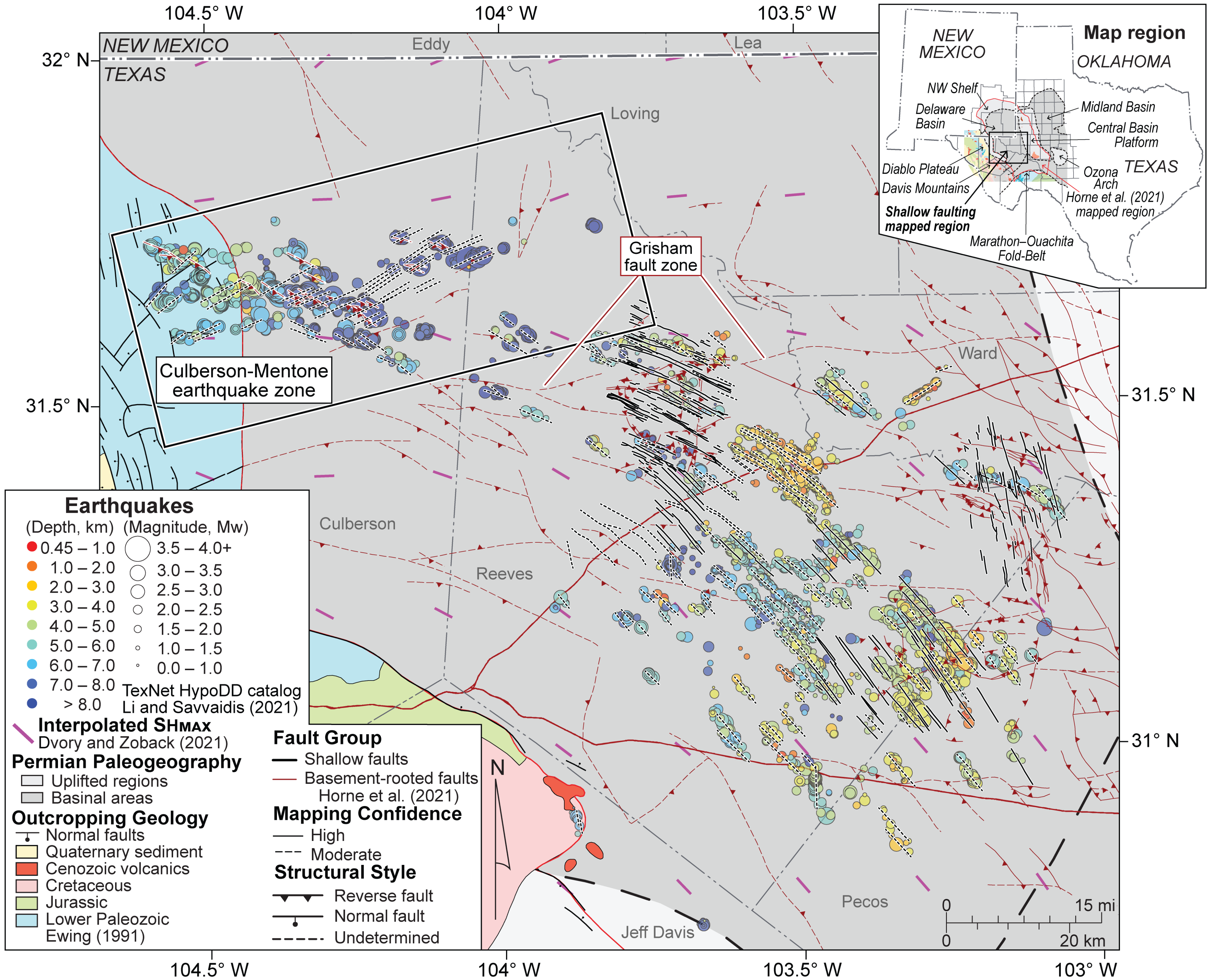
DB1: Map of the central Delaware basin showing newly mapped shallow fault interpretations and basement-rooted fault traces from Horne et al. (2021). Earthquake relative relocations from Li and Savvaidis (2021), hypocentral locations are sized by magnitude and colored by depth of relocated event. Figure and caption taken from Horne et al. (2022).
(2a) Basement-Rooted Faults
A new interpretation of >650 basement-rooted faults was generated to better understand the subsurface architecture of the Delaware Basin and surrounding structural flanks. Faults were classified according to morphology (orientation, length, offset) and mapping confidence (high and moderate) (Fig. DB2). Deformation is dominated by NNW-SSE-striking high-angle reverse faults. These NNW-SSE primary faults are compartmentalized by two secondary fault orientations observed regionally (WNW-ESE & WSW-ENE), the most notable of which is the ENE-striking Grisham fault zone. These secondary faults accommodated significant reverse dip-slip and minor strike-slip movement, contractional fault-propagation folds, and smaller-scale, similarly trending oblique-slip fault zones. A subordinate fault orientation of NNE-SSW is also observed. These faults formed in association with accumulated contractional and localized strike-slip strain between first-and second-order faults. This interpretation can be used to understand controls on issues involving faulting, including but not limited to neotectonic stress state, basin tectonostratigraphic evolution, reservoir productivity and production characteristics, and both natural and induced seismicity.
Horne, E.A., Hennings, P.H., and Zahm, C.K., 2021, Basement-Rooted Faults of the Delaware Basin and Central Basin Platform (O. A. Callahan & P. Eichhubl, Eds.): The University of Texas at Austin, Bureau of Economic Geology Report of Investigations No. 286., 37 p., https://doi.org/10.23867/RI0286C6.
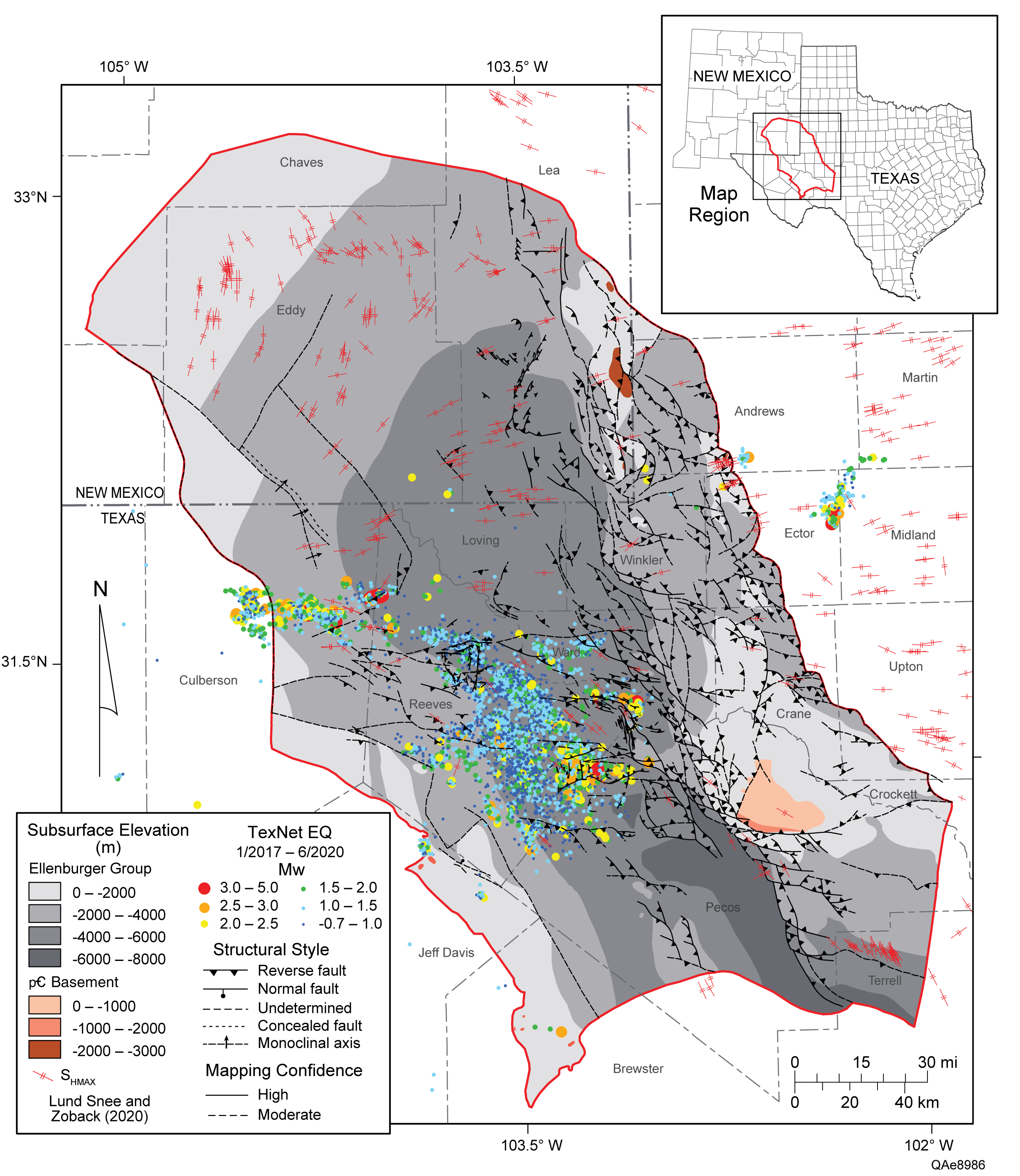
DB2: Figure 16: Updated basement-rooted fault map and TexNet-located earthquake hypocentral data (Savvaidis and others, 2019). In particular, the Delaware Basin is currently experiencing low-magnitude earthquakes, primarily within Reeves, Culberson, and northwestern Pecos Counties. EQ = earthquake. Figure and caption taken from Horne et al. (2021)
Dataset & interpretation confidence
A regional basement-rooted fault map (Fig. DB2) and 3D structural framework of the Delaware Basin and Central Basin Platform was constructed using publicly available and proprietary subsurface data. As with many basin-scale integrated data sets, a sharp contrast exists between low-resolution, regionally extensive data (e.g., well penetrations, published maps and cross sections) and spatially limited, high-resolution data regions (e.g., 3D seismic-reflection data and interpretations) (Fig. DB3). Only 4.4 percent of the mapped region was informed by 3D seismic data, therefore, a regional fault framework model has been constructed through the integration of well penetrations and interpretations from previous publications. Over 3,000 wells were used in this study: 2,283 sampled the Mississippian–Devonian age Woodford Formation, 3,012 sampled the Cambrian–Ordovician Ellenburger Group, and 335 wells sampled the Precambrian basement. These formation tops were used to generate new fault interpretations and produce new structure contour maps, which were compared to published structure contour maps (e.g., Frenzel and others, 1988; Gardiner, 1990; Comer, 1991; Ewing, 1991; Ewing, 2019). Fault traces included in these structure maps were then updated to accommodate these data sources, new faults were identified by observing vertical offsets in these horizons, and in some cases, previously published faults were eliminated if these data did not sufficiently warrant inclusion.
Fault-segment surface interpretations are classified based on interpretation confidence. This classification scheme breaks fault segments into high, moderate, and low interpretation confidences relative to the varying degrees of uncertainty in 3D geometries. High-confidence fault segments have sufficient data to validate their 3D geometry, moderate-confidence fault segments have varying degrees of uncertainty about their 3D geometries (e.g., length, lateral continuity, orientation), and low-confidence fault segments do not have sufficient evidence to warrant inclusion for mapping.
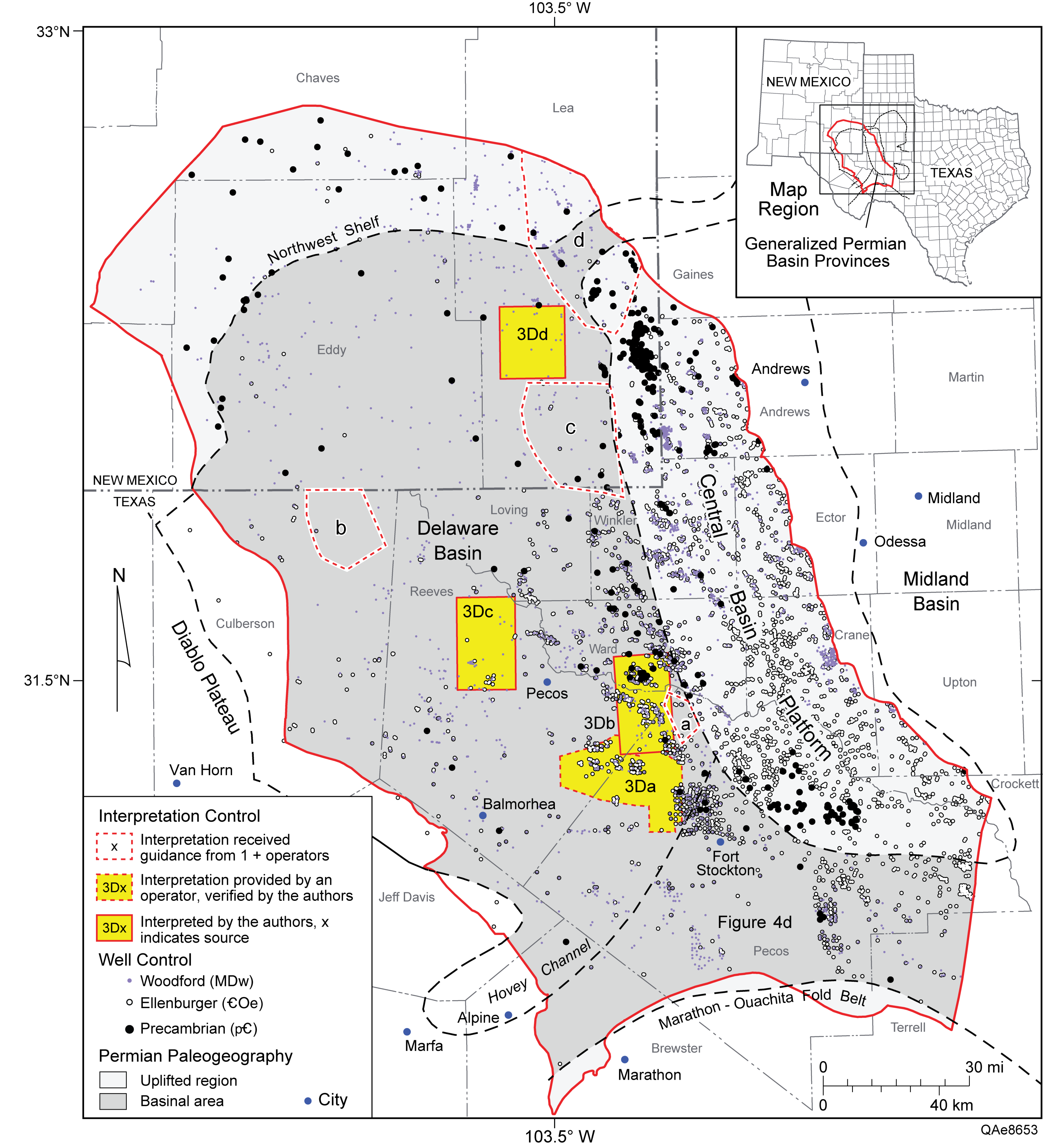
DB3: Data map used to construct regional structural framework for the Delaware Basin. Map highlights well and seismic data used as control for fault framework model. Well penetrations that sample three stratigraphic units are shown by different colored dots. The stratigraphic units and respective dot colors are as follows: Woodford Formation, purple; top of Ellenburger Group, white; and Precambrian basement, black. Three-dimensional seismic–controlled inset areas are shown as yellow polygons. Regional schematic cross section interpretations of the transition between the eastern margin of the Delaware Basin and the western margin of the Central Basin Platform are shown (fig. 4a–4d). Figure Qae8653 from Horne et al. (2021).
References
Fault interpretations
Horne, E.A., Hennings, P.H., and Zahm, C.K., 2021, Basement-Rooted Faults of the Delaware Basin and Central Basin Platform (O. A. Callahan & P. Eichhubl, Eds.): The University of Texas at Austin, Bureau of Economic Geology Report of Investigations No. 286., 37 p., https://doi.org/10.23867/RI0286C6.
Mechanistic analyses & related work
Hennings, P., Dvory, N., Horne, E., Li, P., Savvaidis, A., and Zoback, M., 2021, Stability of the Fault Systems That Host-Induced Earthquakes in the Delaware Basin of West Texas and Southeast New Mexico: The Seismic Record, v. 1, no. 2, p. 96–106, https://doi.org/10.1785/0320210020.
Delaware Basin Deterministic Fault Slip Potential ArcMap Shape Files for “Stability of the Fault Systems That Host-Induced Earthquakes in the Delaware Basin of West Texas and Southeast New Mexico by Peter H. Hennings, Noam Dvory, Elizabeth Horne, Peng Li, Alexandros Savvaisis, and Mark Zoback: https://doi.org/10.18738/T8/TBTRXM
Morris, A.P., Hennings, P.H., Horne, E.A., and Smye, K.M., 2021, Stability of basement-rooted faults in the Delaware Basin of Texas and New Mexico, USA: Journal of Structural Geology, v. 149, p. 104360, https://doi.org/10.1016/j.jsg.2021.104360.
Replication and Supplemental Data for “Stability of Basement-Rooted Faults in the Delaware Basin of West Texas and Southeast New Mexico” by Alan P. Morris, Peter H. Hennings, Elizabeth A. Horne, and Katie M. Smye: https://doi.org/10.18738/T8/XBVRUM.
Smye, K.M., Hennings, P.H., and Horne, E.A., 2021, Variations in vertical stress in the Permian Basin region: AAPG Bulletin, v. 105, no. 10, p. 1893–1907, https://doi.org/10.1306/10092019189.
(2b) Shallow Faults
Shallow faults are vertically decoupled from the basement-rooted faults, accommodate dominantly dip-slip motion, trend parallel to the azimuth of SHMAX, and are the product of more recent processes including regional exhumation. The shallow fault system is composed of NW-SE striking, high-angle, parallel trending faults which delineate a series of elongate, narrow, extensional graben. In contrast to the basin-compartmentalizing, basement-rooted fault system, shallow faults do not display any shear movement indicators, and have small throw displacement given their mapped length, producing an anomalous mean throw-to-length ratio of 1:1000. These characteristics indicate that these features are more segmented than can be mapped with conventional subsurface data. Much of the recent seismicity in the south-central Delaware Basin are associated with these faults and Interferometric Synthetic Aperture Radar (InSAR) surface deformation observations show that these faults may also be slipping aseismically.
Horne, E. A., P. H. Hennings, K. M. Smye, S. Staniewicz, J. Chen, and A. Savvaidis, 2022, Structural characteristics of shallow faults in the Delaware Basin: Interpretation, v. 10, no. 4, p. T807–T835, doi:10.1190/INT-2022-0005.1.
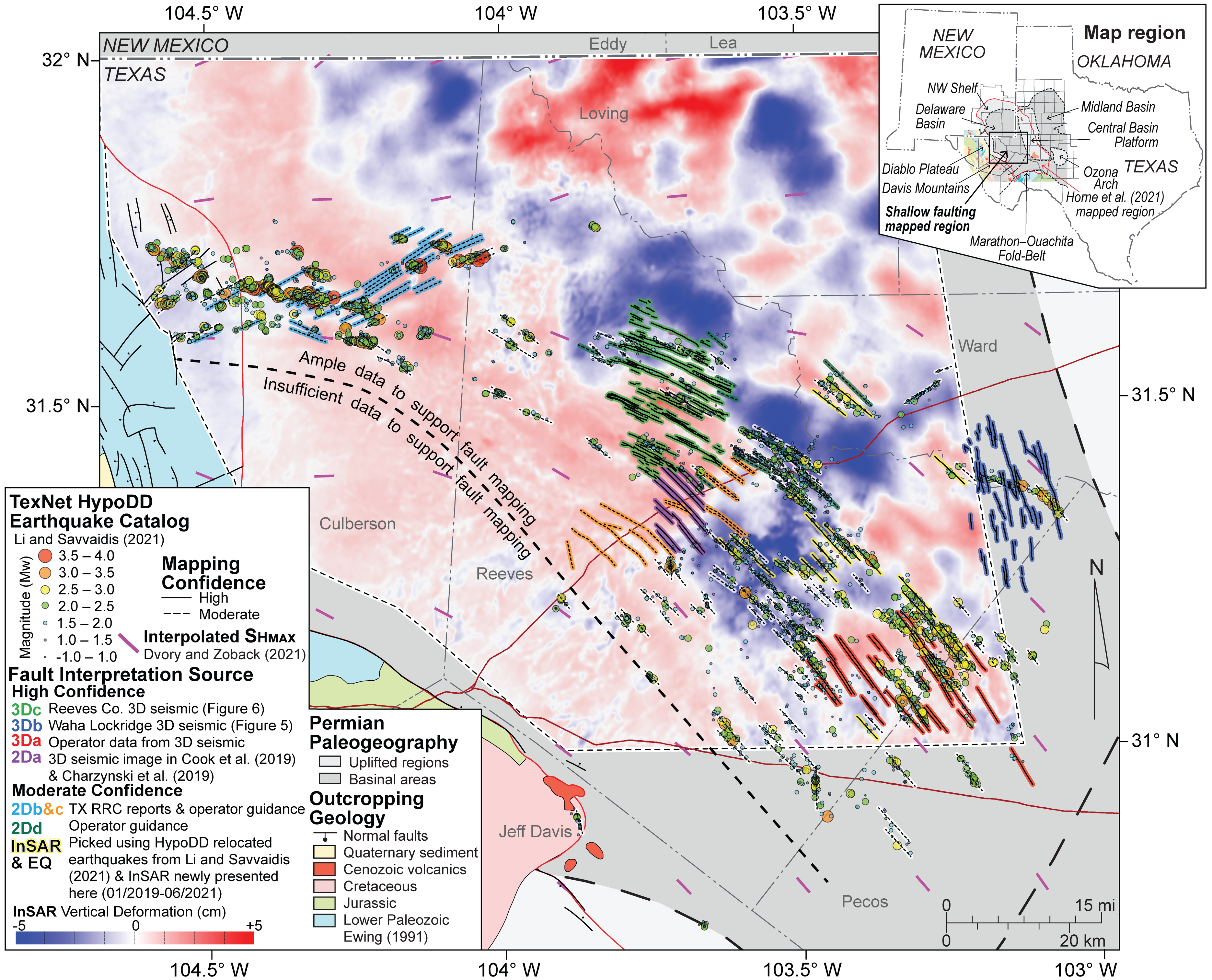
DB4: Fault interpretation of the core seismogenic region of the Delaware Basin. Fault traces are colored by data sources. TexNet HypoDD relocated earthquakes are shown (Li and Savvaidis, 2021) and a newly generated InSAR cumulative vertical deformation map (January 2019 to June 2021) highlights the strong alignment with HypoDD relocated earthquake hypocentral locations. Figure and caption taken from Horne et al. (2022).
Dataset & interpretation confidence
Shallow fault segments are locally controlled using 3D seismic reflection data volumes interpreted by the authors or provided by petroleum operators. Regional patterns of faulting are illuminated through the integration of regional, linear surface deformation features observed from InSAR, earthquake hypocenters and slip-plane orientations calculated from focal mechanism solutions from multiple earthquake catalogs; and the digital integration of all publicly available data, including maps, cross-sections, existing fault interpretations and interpretations from thousands of digital and raster well logs that were sourced from the RRC website (www.rrc.texas.gov) and IHS LogNet®. (Fig. DB4).
Shallow fault segments are classified according to levels in mapping confidence: high, moderate, and low. Fault segments interpreted with high confidence are supported by sufficient data to validate their mapped geometry (i.e., 3D seismic data, interpretations of which are completed in house, provided by operators, or published online). Fault segments interpreted with moderate confidence have varying degrees of uncertainty including their current mapped extent (length, height), geometry, lateral continuity, or specific placement, and are interpreted from patterns of InSAR surface deformation and/or alignment of well-located earthquakes. Low confidence fault interpretations are not mapped.
Downloadable Data
Faults associated with this research are publicly available within the Texas Data Repository and can be accessed through the Digital Object Identifier (DOI) system with DOI: 10.18738/T8/UHWLDR
Savvaidis, Alexandros; Peng, Li, 2020, “TexNet earthquake hypoDD cross correlation relocation catalog of Permian Basin from 20170101 to 20210414”, https://doi.org/10.18738/T8/RBEGTH, Texas Data Repository, V2. TexNet earthquake hypoDD cross correlation relocation catalog of Permian Basin from 20170101 to 20210414.
Staniewicz, Scott; Jingyi Chen, 2020, “Sentinel-1 InSAR Surface Deformation Data over the Permian Basin”, https://doi.org/10.18738/T8/AVDBOJ, Texas Data Repository, V6.
References & Related Research
Hennings, P., Dvory, N., Horne, E., Li, P., Savvaidis, A., and Zoback, M., 2021, Stability of the Fault Systems That Host-Induced Earthquakes in the Delaware Basin of West Texas and Southeast New Mexico: The Seismic Record, v. 1, no. 2, p. 96–106, https://doi.org/10.1785/0320210020.
Delaware Basin Deterministic Fault Slip Potential ArcMap Shape Files for “Stability of the Fault Systems That Host-Induced Earthquakes in the Delaware Basin of West Texas and Southeast New Mexico by Peter H. Hennings, Noam Dvory, Elizabeth Horne, Peng Li, Alexandros Savvaisis, and Mark Zoback: https://doi.org/10.18738/T8/TBTRXM