|
Using
LIDAR in Honduras: Hurricane Mitch
Soon after the
Bureau purchased its own LIDAR unit in 2000, the U.S.
Geological Survey (USGS) asked the Bureau to participate
in an investigation of the impacts of Hurricane Mitch, which struck
Central America in November 1998. Honduras was especially hard-hit,
and flooding, high winds, and landslides destroyed much of the country’s
infrastructure. Honduras is currently rebuilding the housing and
infrastructure destroyed by the hurricane. To minimize the effects
of future storm disasters, the Honduran government needs maps that
clearly define areas prone to flooding and landslides.
The joint Bureau-USGS
team surveyed 15 municipal areas of Honduras. Maps and surveys that
would have been nearly impossible using ground-based methods were
accomplished in a few weeks. Although the data are currently being
processed, initial results have exceeded expectations. The Bureau
feels proud to be playing a small, but critical, role in helping
Honduras recover from one of the worst natural disasters in Latin
American history.
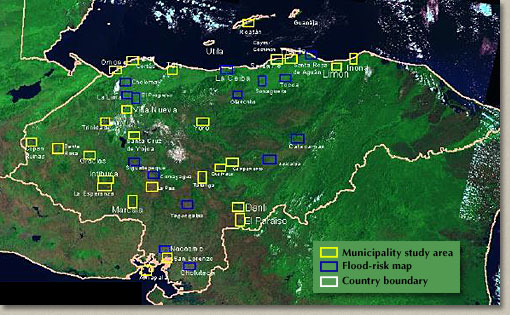
Municipalities
under study by the USGS The Bureau conducted airborne LIDAR surveys
in those areas slated for flood-risk mapping.
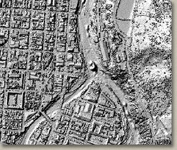
Shaded-relief
topographic image of a portion of the Tegucigalpa Digital Elevation
Model (DEM).
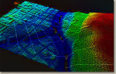
Digital
elevation model and extracted river-channel cross sections. Cross
sections are input to a surface hydrology model.
Mayan Ruins
In addition to flood hazard mapping, and when the field
schedule allowed, Bureau scientists made side trips to Copan to
conduct LIDAR and GPS surveys of the Mayan ruins. These LIDAR and
GPS data are being used by archeologists to develop a GIS database,
a crucial element in the Hondurans’ preservation strategy for
this renowned archeological treasure.
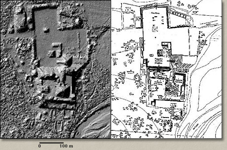
Left
is a shaded-relief topographic image of the Copan Ruins. The image
is from a digital elevation model constructed using only those
LIDAR points that penetrated the vegetation canopy. Right is a
plan of the Mayan structures derived from a ground survey conducted
by Harvard University.
|
