
GREAT PLACE #1
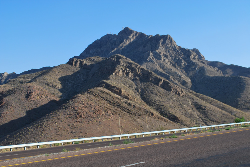
Franklin Mountains
County: El Paso
Landscape Domain: Basin and Range (Franklin Mountains)
Ecoregion: Chihuahuan Desert/Low Mountains and Bajadas
-
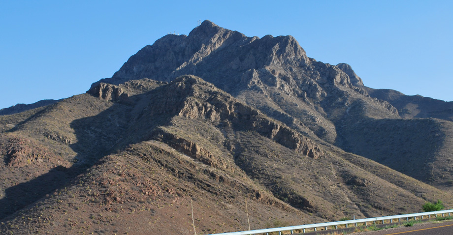
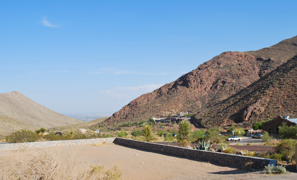
Tilted block of El Paso carbonate, south of Trans-Mountain Rd
-
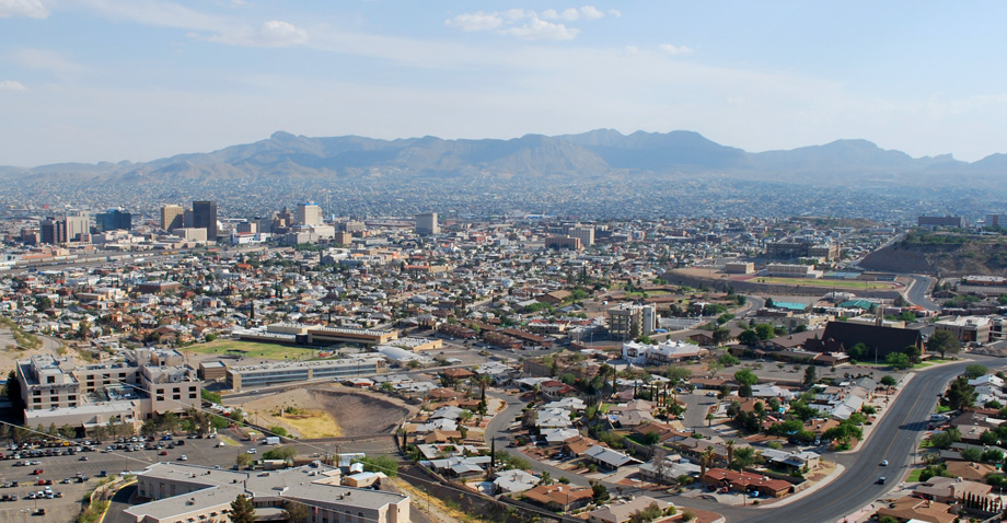
Looking south to El Paso and Juarez
-
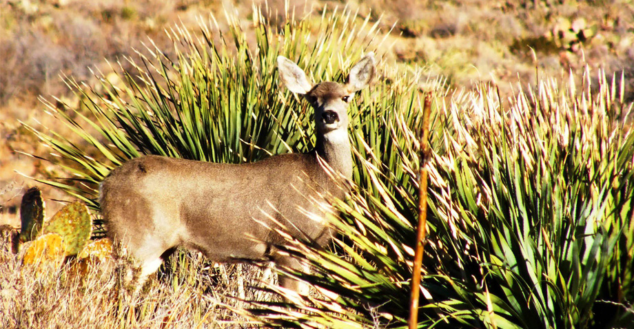
Local wildlife and fauna
Why it's a great place
- Great example of a tilted desert range, with two adjacent basins formed by Neogene extension
- View of the "Texas Lineament"—the contrast between the cities of El Paso and Juarez
- Bedded Ordovician (470-million-year-old) limestone and dolomite, with a visible disconformity in the Ordovician
- View of massive cliffs caused by the collapse of Ordovician caves
- Unusual Precambrian section with limestone, rhyolite, and basalt flows
Did you know?
- The Franklin Mountains are set in the largest urban park in the nation—Franklin Mountains State Park covers 24,247 acres (or 37 square miles), all of which is within El Paso city limits.
- Many well-preserved pictographs, made by Native Americans who inhabited this area for more than 12,000 years, can still be seen around the park.
- The highest peak in the range is North Franklin Peak, which reaches an elevation of 7192 feet above sea level.
El Paso has the most striking geographic and geological features of any city in Texas. The name, originally El Paso del Norte, means "the pass of the north" or "the northern ford"; both are appropriate here. This was the spot where the Camino Real wagon trail, coming north toward New Mexico, crossed the Rio Grande and passed through the narrow gap between the Sierra de Juarez range on the south and the Franklin Mountains on the north. The valley was settled in 1680, mainly by refugees from the Pueblo Revolt in New Mexico. The city of El Paso was originally on the south side of the river; later, the settlement south of the border was renamed Ciudad Juarez in honor of the Mexican national leader of the 1860's. The Texas-side city was formed around Fort Bliss and was established after the Mexican/American War resulted in the east bank becoming U.S. territory. Today, I-10 and the mainline railroad use the same pass the Spanish colonists and traders used on their way to New Mexico and California.
The geographic setting is matched by a striking geologic contrast. On the Mexican side of the river are the Sierra de Juarez Mountains, formed when thousands of feet of Cretaceous carbonates folded and faulted during Laramide compression (60–40 million years ago). Nothing older can be seen. To the north, the Franklin Mountains are a range of Precambrian through Pennsylvanian rocks (some of which are up to 8200 feet thick), all tilted about 40 degrees to the west and faulted as the Rio Grande area pulled apart during the Neogene (20–0 million years ago). In other words, the geology changes completely over the course of just a few miles! This contrast, combined with regional evidence for a northwest-southeast trending corridor of similar contrasts, has been called the "Texas Lineament"; El Paso is its type area. The nature of this lineament has been much debated; it probably is a change in character of the deep crust and lithosphere. But we can't tell from here.
Access from I-10
Scenic Drive: From I-10, exit at Piedras, turn right (north) onto Piedras, continue through Manhattan Heights historic district, turn left on Richmond (after 1.1 miles), and continue several blocks past Alabama until the street becomes Scenic Drive. Continue 1 mile to Scenic Point (with flagpole and parking).
Wyler Aerial Tramway: From Scenic Point, return to Alabama Street and turn left (north), continue 0.9 miles to McKinley Street, turn left and continue up the winding road for 0.9 miles onto the high mesa.
Trans-Mountain Road: From the Tramway, exit the canyon on McKinley St., turn left on Alabama, continue straight on Fred Wilson Ave to US 54 (Gateway North), turn left and continue to Trans-Mountain Road (Loop 375); turn left towards the mountains and continue ascending to Smuggler's Pass (about 4.8 miles).
31°46'57"N 106°28'47"W 4225'
Access level: 0
(Car stops; viewpoints or roadcuts; wheelchair accessible; may have curbs)
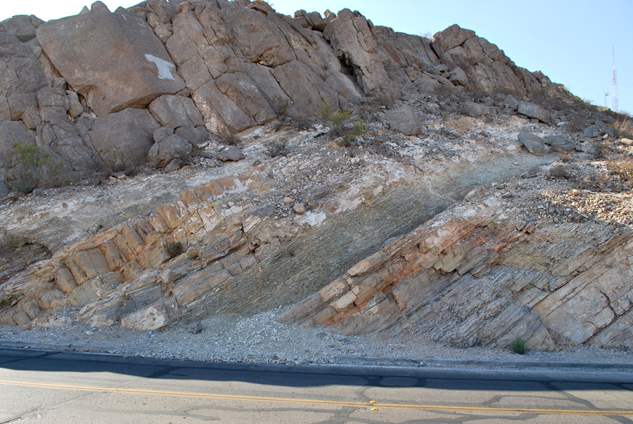
Driving up the twisting road to Scenic Point, the roadcuts are of the El Paso Group carbonates of lower Ordovician age (460 or so million years old). These are the same rocks called 'Ellenburger' in central Texas, and are part of a carbonate platform that extended all the way to New York. Geologists identify several units within the El Paso Group and have identified carbonate mounds, fossiliferous, shallow-water limestone (calcium carbonate) and dolomite (magnesium-calcium carbonate).
At Scenic Point, the road cuts the contact between the youngest El Paso carbonate and the oldest rock of the Montoya Group (Upper Ordovician). There is a significant gap in time due to erosion or non-deposition during the middle Ordovician. However, only a slight change in the water depth and style of deposition occurs across the boundary. Notice the dark gray layers that form slots in the roadcut, they represent marl zones with small amounts of clay. Beneath them are brownish rocks that are composed of dolomite. The cliffy crest of the mountain lies just to the left (west) in the Montoya with a thick, resistant, and fossiliferous Upham dolomite bed.
From Scenic Point there is a wide and wonderful view of El Paso – Juarez, the Texas Lineament (above), and the broad Hueco valley or bolson to the east, the Mesilla valley to the west. Both of these are deep troughs bounded by normal faults (over 20,000 feet of displacement!), filled with sands and gravels (and some deposits of saline lakes or playas) that are major freshwater sources. The tilting and faulting of the Franklin Mountains and the subsidence of the bolsons on either side are part of the same process of pulling apart the crust in the El Paso and Rio Grande area – the southern end of the 'Rio Grande Rift' which extends into Colorado.
31°50'32"N 106°29'10"W 4832'
Access level: 0
(Car stops; viewpoints or roadcuts; fully accessible; may have curbs)
To the north, McKelligon Canyon cuts into a variety of rock types. To the left as we enter the canyon are cliffs of Precambrian granite (Red Bluff granite, about 1100 million years old) – but to the right are west-dipping limestone beds of the El Paso Group.The canyon lies along a fault that displaces the El Paso beds down on the right and up on the left. At the picnic area on the west side of the canyon, we can reach and examine the top of the Precambrian. There, the Bliss Formation sandstones (at the base of the El Paso Group) fill and overlap the erosion surface on the Precambrian. These were the beaches deposited during the advancing El Paso sea.
Up high on the mountain to the west, large areas of breccia have been mapped in the El Paso Group outcrop. These were formed by collapsed cavern systems that were dissolved during the time of the pre-Montoya unconformity – Middle Ordovician.
31°53'37"N 106°27'34"W 4454'
Access level: 0
(Car stops; viewpoints or roadcuts; fully accessible; may have curbs)
Roadcuts along the Trans-Mountain Road (Loop 359) are the best and most diverse roadside exposures of Precambrian rock in Texas. The largest volume of the Precambrian is made up of the Red Bluff granite (1120 million years old), overlain by volcanic rocks (Thunderbird Group) that are formed by the same magmas. Other rocks – limestones (Castner; to 1390 feet thick; 1272 million years old from ash beds), basaltic volcanic breccias (Mundy Breccia, 0-250 feet), and sandstone and shale (Lanoria quartzite, 1200 feet) are 'floating' in the granite (that is, granite has intruded around big blocks of these rocks), and are metamorphosed. The road traverses the old Castner Firing Range; be careful if you go walking away from the road!
From the intersection with US 54, the first roadcut is at 1.4 miles; it displays a series of xenoliths of dark Castner limestone (or marble) floating in granite (stop 2 Barnes; 3 LeMone). At the west end is a great exposure of vertically-dipping Castner. A pegmatite related to the granite that contains riebeckite prisms (sodic amphibole mineral) is well exposed at the east-end. At 2.1 miles, another roadcut shows a granite sill (stop 4 LeMone).
At 2.5 miles, Castner gray-brown marble is exposed at the road, including stromatolites; there are also black mafic igneous sills in the sequence. Garnets occur in the rocks near the top of the unit. (Stope 5-7 LeMone). Mundy Breccia overlies the Castner, but these relationships require walking up the hill to the right. At 2.8-3.0 miles there is a long roadcut in a thick granite sill (stop 8 LeMone); the towers of South Franklin Peak are visible ahead. A poor roadcut in Lanoria rocks is 0.3 miles ahead (stop 9 LeMone). We enter the state park at 3.8 miles, and pass a trailhead at 4.3 miles. Notice that South Franklin Peak is Ordovician carbonate. Near the crest of the pass is a large cut in the Thunderbird Group strata, with a basal conglomerate overlain by trachyte porphyry and tuff, then by a thick rhyolite ignimbrite (Stop 10 LeMone).
At the crest of Smugglers Pass (4.8 miles from US 54; stop 12 LeMone) is a view (on a clear day) of the Mesilla Valley; and, on the skyline to the west, the volcanic field of the Potrillo Mountains in southern New Mexico.
Texas Parks & Wildlife Department website
M.E. Bickford, K. Soegaard, K.C. Nielsen, and J.M. McLelland, 2000, Geology and geochronology of Grenville-age rocks in the Van Horn and Franklin Mountains area, west Texas: implications for the tectonic evolution of Laurentia during the Grenville: GSA Bulletin, v. 112, p. 1134-1148.
E.W. Collins and J.A. Raney, 2000, Geologic map of west Hueco Bolson, El Paso region, Texas: BEG MM 40
P.E. Cloud, Jr. and V.E. Barnes, 1946, The Ellenburger Group of central Texas: UT Publication 4621, 473p.
(R.L. Harbour, 1972, Geology of the northern Franklin Mountains, Texas and New Mexico: USGS Bulletin 1298)
D.V. LeMone, 1988, Precambrian and Paleozoic stratigraphy; Franklin Mountains, west Texas: #87-88 in Geological Society of America Centennial Field Guide – South Central Section, p. 387-394.
C.G. Barnes, K.M. Marsaglia, J.M. Seeley, M.A. Seward, W.M. Shannon, and W.F. Thomann,1991, The Proterozoic section in the Franklin Mountains: in Examples of Modern rift volcanism and Proterozoic anorogenic magmatism: the Potrillo volcanic field of southern New Mexico and the Franklin Mountains of west Texas: NMBMMR Bulletin 137, p. 1-12
The Tom Mays Unit of Franklin Mountains State Park lies north of the Trans-Mountain Road and has facilities and trails. To the north of this development towards Vinton Canyon, a complete section of units overlying the Montoya – Fusselman (Silurian), Mississippian, Pennsylvanian, and lower Permian carbonates are exposed and may be accessible by trail. Also to the north just into New Mexico is another trans-mountain road with views and roadcuts in Pennsylvanian carbonates.