|
Airborne Geophysical Surveys
A second Lower Rio Grande Valley project conducted by the Bureau
involves the use of new airborne geophysical surveys to determine possible
sources of groundwater. This work, if successful, could be easily applied
to adjacent areas in Mexico.
To assist Mexican
researchers in their search for resources, Bureau scientists have traveled
to Mexico to deliver presentations and to hold workshops for Mexican groundwater
professionals. Bureau scientists involved in airborne geophysical surveys
and hydrogeologic studies include Jeffrey
G. Paine and Alan
R. Dutton.
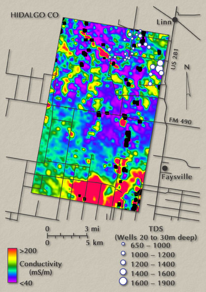
Patterns
evident on conductivity images at a shallow depth (30 m) north of McAllen
reflect lateral and vertical changes in water quality and sediment or
rock type. The concentration of wells producing relatively fresh water
in the upper part of the image fall in an area of low electrical conductivity.
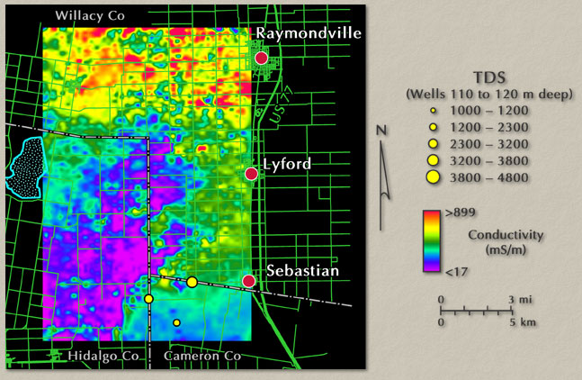
The
color image of an area north of Brownsville depicts the electrical conductivity
110 m below the ground surface as measured by an airborne EM system.
Cool colors indicate relatively poor conductivity and warmer colors
indicate relatively high conductivity. Because water becomes more electrically
conductive as its dissolved mineral content increases, the poorly conductive
areas in general are better areas to explore for ground water at this
depth. In addtion, shapes of conductivity anomalies can be used to infer
the geologic environment. Three wells drawing water from about this
depth confirm that ground-water quality is better where conductivity
is lower.
Lower Rio Grande
Riparian Corridor
Researchers at the Bureau are currently involved in a multidisciplinary
study of the Lower Rio Grande riparian corridor. (The term "riparian"
describes the banks surrounding bodies of water; for this study, riparian
corridor refers to the banks of the Rio Grande.) Riparian zones are characterized
by high plant and animal species diversity and are among the most productive
ecosystems in North America. The rapid decline of riparian ecosystems
in the United States, however, has made their preservation an important
goal of governmental and private organizations. This study, funded by
the U.S.
Environmental Protection Agency, involves collecting a wide range
of data to assess current corridor conditions and building a comprehensive
database to help guide future assessments. Bureau scientists involved
in riparian studies include Jay
A. Raney, Thomas
A. Tremblay, William
A. White, and researchers from the UT Center
for Space Research, The
University of Texas-Pan American, and The
University of Texas at Brownsville.
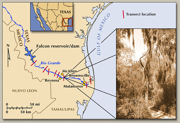
Map
of Lower Rio Grande valley showing approximate location of existing
ecological transects and example of riparian vegetation in the Santa
Ana National Wildlife Refuge.
|
