| |
 PROJECT
SUMMARY PROJECT
SUMMARY
INTRODUCTION
The
Bureau of Economic Geology's 4-year Offshore Secondary Gas Recovery
project (SGR), which started in 1998, is a fully integrated study
funded by the U.S. Department of Energy, whose goal is to research
new techniques and methods in defining the structure, stratigraphy,
and hydrocarbon character of two adjacent, complex, multireservoir
natural gas fields in the Federal offshore. Utilizing multidisciplinary
techniques and methods, project researchers will ultimately identify
additional gas resources, as well as predict regional trends in
hydrocarbon accumulation. This project is the latest in a line of
collaborative BEG-industry investigations that began in 1988 with
the goal of improving gas-recovery efficiency in complex onshore
reservoirs. Projects in onshore Gulf Coast sandstones, sandstones
of the Fort Worth Basin, and karsted carbonate reservoirs of the
Permian Basin have successfully defined secondary, or incremental,
gas recovery on the basis of targeting reservoir heterogeneity.
The Offshore SGR project required identification of at least one
suitable mature field with adequate data and an industry partner
willing to actively participate in the project. Texaco Exploration
and Production Inc. agreed to participate and contribute the in-kind
value of all field data, such as well log data, production histories,
sample and core data, and, most important, a 3-D seismic survey
from a 352-mi2 area within the Vermilion and South Marsh
Island Areas, northwest Gulf of Mexico. Texaco provided all well-related
data for the adjacent Starfak (formally Vermilion Block 50) and
Tiger Shoal fields within the seismic survey.
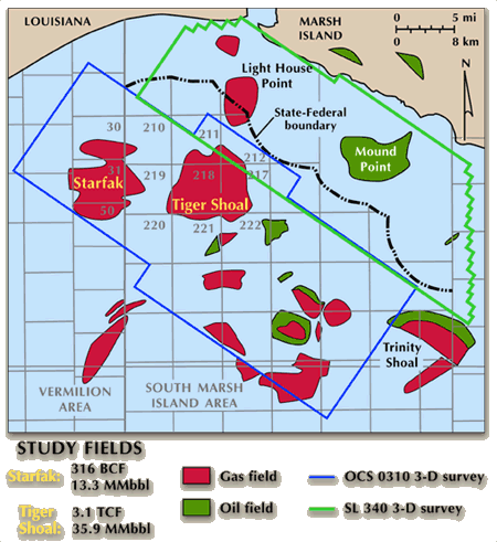 |
| Map
of the Vermilion and South Marsh Island Areas showing the study's
primary target fields, Starfak and Tiger Shoal, as well as surrounding
fields and the outline of the two major 3-D seismic surveys
being used in this resource assessment. |
The
data comprise a variety of types and vintages. Geologic and production
data are being integrated with geophysical data via Landmark©
and Access©
software.
Objectives of
fiscal year 2000–2001 are to complete the integration of the
high-resolution sequence-stratigraphic framework with the seismic
data throughout the 3-D volume: produce a library of net sand isopach,
structure, isolith, and production maps of productive fourth-order
systems tracts; examine hydrocarbon migration into productive areas
and fault-sealing capacity; produce a portfolio of resource-growth
opportunities; and develop enhanced methods for quick interpretation
and targeting of productive trends.
SUMMARY
OF PROGRESS
Completed
and ongoing tasks for FY 2000–-2001 include:
- Integration
of various geologic, production, engineering, and petrophysical
data bases into Landmark© and Oil Field Manager© software
(completed). These data compilations will ultimately
enable comprehensive risk assessment of potential resource/reserve
targets in Starfak and Tiger Shoal fields.
- Construction
of the structural framework (faults) for the entire 3-D seismic
data base (completed). Active geophysical tasks include:
(1) depositional-facies analysis by pattern recognition of seismic
stratal slices, including pattern geometry, pattern texture,
GR/SP log pattern, amplitude (seismic-lithology relationship),
and sequence-stratigraphic relationships; (2) construction of
porosity data base for all the wells (for attribute analysis
and reservoir modeling); and (3) correlation and mapping of
maximum flooding surfaces within the 3-D seismic volume.
- Correlation
of all sequence-stratigraphic surfaces (as many as ~180 per
well) within the Miocene section of the two fields (completed),
integration of fault segments identified by regional geophysical
analysis with the faults identified on well logs within the
two fields (completed), linking the full suite of seismic
facies images (amplitude stratal slices) to the sequence-stratigraphic
framework (completed), reprocessing of the 3-D seismic
data to improve resolution for the deep Robulus L reservoir
intervals to yield better correlation between well and seismic
data (completed).
- Allocation
of resources within the finalized sequence-stratigraphic framework
and definition of historical production trends within specific
sequences and systems tracts (completed).
- Correlation
of comprehensive production statistics with the sequence-stratigraphic
framework of productive zones within Starfak and Tiger Shoal
fields (completed). Through July 1, 2000, 92.6% of total
hydrocarbon production in the fields has come from the lowstand
systems tracts of the third-order sequences. Because of the
obvious importance of these genetic intervals for targeting
future reserve-growth opportunities, we have mapped (1) third-order
maximum flooding surfaces within and just above the highly productive
third-order lowstand accumulations to delineate the time-depth
structure of these surfaces, (2) interval thickness (isochrons)
between these key maximum flooding surfaces, and (3) root mean
square (RMS) amplitude anomalies extracted between bounding
maximum flooding surfaces (completed).
- Initiation
of Neural Networks application of seismic-attribute analysis
for reservoir modeling (active).
- Construction
of detailed maps of net sandstone, thickness, net porosity,
and other parameters of high-frequency (fourth-order) systems
tracts within third-order lowstand systems tracts, the most
productive intervals in the offshore Miocene succession (active).
The objective is to more precisely delineate production fairways
at the reservoir scale and to determine the control(s) on hydrocarbon
accumulation within these fairways.
- Detailed
analysis of petrophysical data from each well in Starfak and
Tiger Shoal field (active). The petrophysical study comprises
analyses of all known and potential reservoirs of net pay, net
sand, water saturation, effective porosity, permeability to
air, effective permeability to gas, irreducible water saturation,
and irreducible bulk volume water. All of the relevant data
will be used to estimate both current and original hydrocarbons
in place.
- Three-dimensional
reservoir modeling, flow simulation, and visualization of between-well
scale heterogeneity within the study area using ROXAR©
RMS software (active).

|