|

Introduction
Geologic
Setting
Outcrop
Characterization
Depositional
Model for the East Ford Unit
Petrophysical
Characterization
Field
Development History
Estimate
of Tertiary Recovery
Acknowledgments
References
|
|
| Figure
3. Sandstone Production |
|
|
|
Figure
4. Ramsey sandstone trends
|
|
|
| Figure
5. Depositional model |
|
|
| Figure
6. Ramsey 2 sandstone thickness |

 |
|
Figure
7. East Ford cross section
|
 |
| Figure
8. Average porosity |
|
|
|
Figure 9. Average permeability |
|
|
| Figure
10. Primary production |
|
|
 PROJECT
SUMMARY PROJECT
SUMMARY
INTRODUCTION
Slope and basin clastic
reservoirs in sandstones of the Delaware Mountain Group in the Delaware
Basin of West Texas and New Mexico contained more than 1.8 billion barrels
(Bbbl) of oil at discovery. Recovery efficiencies of these reservoirs
have averaged only 14 percent since production began in the 1920’s,
and, thus, a substantial amount of the original oil in place remains unproduced.
Many of these mature fields are nearing the end of primary production
and are in danger of abandonment unless effective, economic methods of
enhanced oil recovery can be implemented. The goal of this Class III project
is to demonstrate that reservoir characterization, using outcrop characterization,
subsurface field studies, and other techniques, integrated with reservoir
simulation, is a cost-effective way to recover more original oil in place
by geologically based field development.
The project is focused
now on reservoir characterization of the East Ford unit (Dutton and others,
1999), a representative Delaware Mountain Group field that produces from
the upper Bell Canyon Formation in the Delaware Basin (figure
1). The field, discovered in 1960, is operated by Orla Petco, Inc.,
as the East Ford unit; it contained an estimated 18.4 million barrels
(MMbbl) of original oil in place. The main reservoir in the East Ford
unit is the Ramsey sandstone in the upper Bell Canyon Formation (figure
2). Earlier reservoir characterization for this project was conducted
on the Ford Geraldine unit (Dutton and others, 1997), which is immediately
adjacent to the East Ford unit and produces from a branch of the same
Ramsey sandstone channel (figure
3). Abundant subsurface data were available from the Geraldine Ford
unit for reservoir characterization, including cores from 83 wells, core
analyses from 152 wells, and 3-D seismic over the entire unit. In contrast,
the smaller subsurface data base from the East Ford unit is more typical
of most Delaware sandstone fields. Reservoir characterization of the East
Ford unit has provided an excellent opportunity to test the transferability
of the reservoir model and the methodology developed during reservoir
characterization of the Ford Geraldine unit to another Ramsey sandstone
field.
top
of page
GEOLOGIC
SETTING
Upper Permian (Guadalupian)
Delaware Mountain Group strata compose a 3,500-ft-thick succession of
slope and basin deposits in the Delaware Basin that are important contributors
to Permian Basin production. Production from the Ford Geraldine and East
Ford units and other upper Bell Canyon fields in the Delaware Basin occurs
from the distal (southwest) ends of east-dipping, northeast-oriented linear
trends of thick Ramsey sandstone deposits (figure
4). Most hydrocarbons in these fields are trapped by structurally
updip facies changes from higher permeability reservoir sandstones to
low permeability siltstones (Dutton and others, in press).
top
of page
OUTCROP
CHARACTERIZATION
Interpretation of
the reservoir sandstones at the East Ford unit was based strongly on characterization
of upper Bell Canyon exposed in outcrop. Outcrops of the Bell Canyon Formation
are present within 25 mi of the East Ford unit. These outcrops were studied
to better interpret the depositional processes that formed the reservoirs
at the Ford Geraldine and East Ford units and to determine the dimensions
and characteristics of reservoir sandstone bodies in well-exposed sections
(Barton and Dutton, in press).
Stratigraphic relationships
indicate that the outcrop sandstones were deposited in a basin-floor setting
by a system of leveed channels having attached lobes and overbank splays
that filled topographically low interchannel areas (figure
5). The sandstones are interpreted as having been deposited by sandy
high- and low-density turbidity currents. Lobe sandstones, as much as
25 ft thick and 2 mi wide, are composed of massive or structureless sandstones,
and they display a broad tabular geometry. Channels, as much as 60 ft
thick and 300 to 3,000 ft wide, are largely filled with massive and cross-stratified
sandstone. Flanking the channels on both sides are wedges composed of
thinly bedded sandstone and siltstone that are interpreted as levees.
The levees thin away from the channel, decreasing in thickness from 20
to 3 ft over the distance of 0.5 mi. The levees are onlapped by massive
sandstones interpreted as overbank splays having an irregular geometry.
Individual channel-levee
and lobe complexes appear to stack in a compensatory fashion and are separated
by laterally continuous, 3-ft-thick laminated siltstones. The laminated
siltstones are interpreted to have been deposited by the settling of marine
organic matter and airborne silt during periods when coarser particles
were prevented from entering the basin.
DEPOSITIONAL
MODEL FOR EAST FORD UNIT
Subsurface mapping,
study of Bell Canyon sandstones in outcrop, and descriptions of Ramsey
sandstone cores from the adjacent Ford Geraldine unit indicate that reservoir
sandstones at the East Ford unit were deposited by turbidity currents
in a deep-water channel-levee and lobe system. Ramsey sandstone channels
at the East Ford unit, 1,000 to 1,500 ft wide and 15 to 30 ft thick, are
flanked by levee deposits (figure
6). Lobe facies were deposited at the mouths of channels. Throughout
the East Ford unit, the Ramsey sandstone is divided into two sandstones
(Ramsey 1 and Ramsey 2) separated by a 1- to 3-ft-thick laminated siltstone
(SH1). The best leases in the field produce from what are interpreted
to be channel facies in the Ramsey 1 and 2 sandstones near the center
of the unit (Dutton and others, 1999). The thickest part of the Ramsey
2 channel occurs somewhat to the west of the Ramsey 1 channel, suggesting
that the Ramsey 2 sandstone was deposited in the topographic low to the
west of the thick Ramsey 1 sandstone (figure
7). The SH1 siltstone, though thin, is significant in that it will
affect displacement operations. Because of the low permeability of the
siltstone, there will be very limited cross flow of fluids between the
two sandstones.
top
of page
PETROPHYSICAL
CHARACTERIZATION
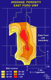
Reservoir characterization
also focused on applying petrophysical techniques to the mapping of reservoir
properties in the East Ford unit. Our approach to quantitative petrophysical
analysis using old log suites was developed in the Ford Geraldine unit
because of the abundant core and core-analysis data available (Asquith
and others, 1997). We started from traditional methods of log interpretation
and integrated them with new methods for (1) determining true formation
resistivity (Rt) from Deep Laterologs (LLD) and (2) calculating saturation
exponent (n) using core porosity and water-saturation values from relative
permeability curves. Much of the approach, but not all, was transferred
successfully to the East Ford unit, where the technique was modified to
calculate water saturation. The result was a set of maps of porosity (figure
8), permeability (figure
9), net pay, water saturation, porous hydrocarbon volume, and other
reservoir properties across the unit. The maps of average porosity and
permeability exhibit a strong north-south trend that follows the positions
of the Ramsey 1 and 2 sandstone channels.
FIELD
DEVELOPMENT HISTORY
Primary recovery in
East Ford field began in October 1960 and continued until June 1995. A
total of 45 wells were drilled for primary production. Primary cumulative
oil production was 3,209,655 bbl. An estimated 10 percent of the total
production, or 320,966 bbl, was from the Olds sandstone. The estimated
2,888,690 bbl produced from the Ramsey sandstone represents 15.7 percent
of the 18.4 MMbbl of original oil in place. Remaining oil in place (ROIP)
in the Ramsey sandstone is 15.6 MMbbl.
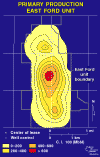
Primary production
data in the East Ford unit were collected by lease, not by individual
well. To map primary oil production, production for each lease was plotted
at the geographic center of the wells that produced from the Ramsey sandstone
(figure
10). Highest production at the north end of the field occurs along
the position of the Ramsey 2 channel, whereas at the south part of the
field the highest production is shifted to the east, at the position of
the Ramsey 1 channel.
The East Ford unit,
like other Delaware sandstone reservoirs, is characterized by relatively
high amounts of mobile water at the time of discovery. Primary recovery
by solution gas drive was low, less than 16 percent. Among the reasons
for the low primary production are (1) the small amount of gas in solution
with the oil to act as a driving force, (2) the expenditure of considerable
solution-gas drive energy in the recovery of water from the reservoir,
and (3) the lack of pressure support from the aquifer owing to the limited
water influx (W. Flanders, written communication, 1994).
Because waterflooding
in Ramsey sandstone reservoirs in other fields has not been very successful,
the East Ford unit did not undergo secondary recovery by waterflooding.
In the Ford Geraldine unit, waterflooding added only an estimated 3.5
percent of the OOIP to the total recovery by the end of secondary development.
Waterflood recoveries in Ramsey sandstones have been low because of poor
sweep efficiency caused by (1) abundant mobile water present when the
waterflood was started and (2) water injection above the formation parting
pressure. Geologic heterogeneity caused by depositional and diagenetic
processes may also reduce secondary recovery in Delaware sandstone reservoirs.
Laminated siltstone beds and extensively calcite-cemented sandstones cause
reservoir complexity and may reduce sweep efficiency
Tertiary recovery
in the East Ford unit by CO2 injection began in July 1995, and production
response to the CO2 injection was observed in December 1998. During Phase
2 of the project, production from the East Ford unit will be monitored
and compared with predictions made on the basis of flow-model simulations.
This comparison will provide an opportunity to evaluate the success of
these operations and to test the accuracy of reservoir-characterization
and flow-simulation studies as predictive tools in resource preservation
of mature fields.
top
of page
ESTIMATE
OF TERTIARY RECOVERY
To estimate the tertiary
recovery potential, we applied the results of fluid-flow simulations of
a CO2 flood in the Ramsey sandstone to the East Ford unit. The area simulated
was the north end of the Ford Geraldine unit (Malik, 1998), which is similar
to the East Ford unit, both in terms of reservoir thickness and in the
separation of the Ramsey sandstone into two parts by the SH1 siltstone.
Independent estimates of tertiary recovery from the East Ford unit were
made on the basis of the results of the CO2 flood performed in the south
part of the Ford Geraldine unit. Both methods of estimating tertiary recovery
in the East Ford unit indicate that a minimum of 10 percent, and as much
as 30 percent, of remaining oil in place is recoverable through a CO2
flood. Original oil in place in the CO2 flood area within the East Ford
unit was approximately 14.7 MMbbl, and of that, 2.5 MMbbl were produced
during primary production. Of the 12.2 MMbbl of remaining oil in place
in this area, an estimated 1.2 to 3.7 MMbbl is recoverable through CO2
flood.
top
of page
ACKNOWLEDGEMENTS
This research was
funded by the U. S. Department of Energy under contract no. DE-FC22-95BC14936,
by Conoco, Inc., and by the State of Texas under State Match Pool Project
4201 and as part of the State of Texas Advanced Resource Recovery project.
The Bureau of Economic Geology acknowledges support of this research by
Landmark Graphics Corporation via the Landmark University Grant Program.
top
of page
REFERENCES
Asquith, G. B., Dutton,
S. P., Cole, A. G., Razi, M., and Guzman, J. I., 1997, Petrophysics of
the Ramsey Sandstone, Ford Geraldine Unit, Reeves and Culberson Counties,
Texas: West Texas Geological Society Publication No. 97-102, p. 61-69.
Barton, M. D., 1997,
Facies architectureof submarine channel-levee and lobe sandstones: Permian
Bell Canyon Formation, Delaware Mountains, West Texas: The University
of Texas at Austin, Bureau of Economic Geology Field Trip Guidebook, 40
p.
Barton, M. D., and
Dutton, S. P., in press, Outcrop analysis of a sand-rich, basin-floor
turbidite system, Permian Bell Canyon Formation, West Texas, in Hentz,
T. F., ed., Advanced reservoir characterization for the twenty-first century:
Gulf Coast Section SEPM 19th Annual Research Conference.
Dutton, S. P., and
Barton, M. D., in press, Application of outcrop analogs to reservoir characterization
of Permian deep-water sandstones, Bell Canyon Formation, Ford Geraldine
unit, West Texas (Delaware Basin), in Hentz, T. F., ed., Advanced reservoir
characterization for the twenty-first century: Gulf Coast Section SEPM
19th Annual Research Conference.
Dutton, S. P., Barton,
M. D., Asquith, G. B., Malik, M. A., Cole, A. G., Gogas, J., Guzman, J.
I., and Clift, S. J., in press, Geologic and engineering characterization
of turbidite reservoirs, Ford Geraldine Unit, Bell Canyon Formation, West
Texas: The University of Texas at Austin, Bureau of Economic Geology Report
of Investigations No. 255, 88 p.
Dutton, S. P., Flanders,
W. A., Zirczy, H. H., and Guzman, J. I., 1999, Geologic and engineering
characterization of East Ford field, Reeves County, Texas: The University
of Texas at Austin, Bureau of Economic Geology, topical report prepared
for the U.S. Department of Energy, 113 p.
Dutton, S. P., Malik,
M. A., Clift, S. J., Asquith, G. B., Barton, M. D., Cole, A. G., Gogas,
J., and Guzman, J. I., 1997, Geological and engineering characterization
of Geraldine Ford Field, Reeves and Culberson Counties, Texas: The University
of Texas at Austin, Bureau of Economic Geology, topical report prepared
for the U.S. Department of Energy, 115 p.
Galloway, W. E., and
Hobday, D. K., 1996, Terrigenous clastic depositional systems, 2nd ed.:
New York, Springer-Verlag, 489 p.
Malik, M. A., 1998,
Compositional simulations of a CO2 flood in Ford Geraldine Unit, Texas:
SPE paper 39794, 1998 SPE Permian Basin Oil and Gas Recovery Conference,
Midland, TX, March 23-26, 1998, p. 375-383.
Silver, B. A., and
Todd, R. G., 1969, Permian cyclic strata, northern Midland and Delaware
Basins, west Texas and southeastern New Mexico: American Association of
Petroleum Geologists Bulletin, v. 53, p. 2223-2251.
Williamson, C. R.,
1978, Depositional processes, diagenesis and reservoir properties of Permian
deep-sea sandstones, Bell Canyon Formation, Texas-New Mexico: The University
of Texas at AUstin, Ph.D. dissertation, 262 p.
top
of page
|