The Midland Basin of Texas is experiencing elevated rates of seismicity linked to oilfield wastewater disposal, with >156 Mw +3.0 earthquakes between 1/2017-1/2024. This region also has a complex tectonic history, involving several periods of convergence and divergence since the Proterozoic. Each subsequent event was influenced by the accumulated tectonic fabric through fault reactivation and strain transfer. These events have generated a complex network of regional faults, which include contractional, high-angle reverse and near vertical oblique–strike-slip basement-rooted faults (Fig. MB1). We present a regionally complete map of 795 basement-rooted faults, expressed as high-angle reverse and near-vertical strike-slip faults. High-angle reverse faults that strike NNW-SSE define the eastern margin of the Central Basin Platform and generate the greatest structural relief. East of the Central Basin Platform, NNW-SSE and NNE-SSW striking reverse faults bound low-amplitude uplifts. Reverse faults are accompanied by WNW-ESE and WSW-ENE striking strike-slip faults, which limit the lateral length of reverse faults and associated uplifts, coinciding with a reversal in fault-bounded uplift vergence direction, and exhibit evidence for transpressional translation. These observations suggest that reverse structures initiated during Late Paleozoic orogenesis, but WNW-ESE and WSW-ENE striking strike-slip faults are the Late Paleozoic reactivation of a long-standing Proterozoic fabric. These basement-rooted high-angle reverse and reverse–strike-slip faults are reactivating as normal and normal–strike-slip faults under present day stress conditions due to modest pore pressure perturbations (Fig. MB2). Our results provide a foundation to investigate causal behavior, characterize fault slip hazard, and can therefore be used to plan and regulate ongoing petroleum operations.
Horne, E.A., Hennings, P.H., Smye, K.M., Calle, A.Z., Morris, A.P., and Huang, G.-C. D., 2024, Interpretation, Characterization and Slip Hazard Assessment of Faults in the Midland Basin, West Texas, USA: The Bulletin of the American Association of Petroleum Geologists, https://doi.org/10.1306/01242423080
Downloadable Data
Basement-rooted faults are publicly available as GIS Shapefiles within the Texas Data Repository and can be accessed through the Digital Object Identifier (DOI) system with DOI: 10.18738/T8/ZTBOGP. With this work peer-reviewed and published, we maintain the original interpretation (V1) in this data repository. We also provide an update of this interpretation periodically, as more data becomes available to the interpreters. The updated shapefile will be denoted by iteration and date (V#).
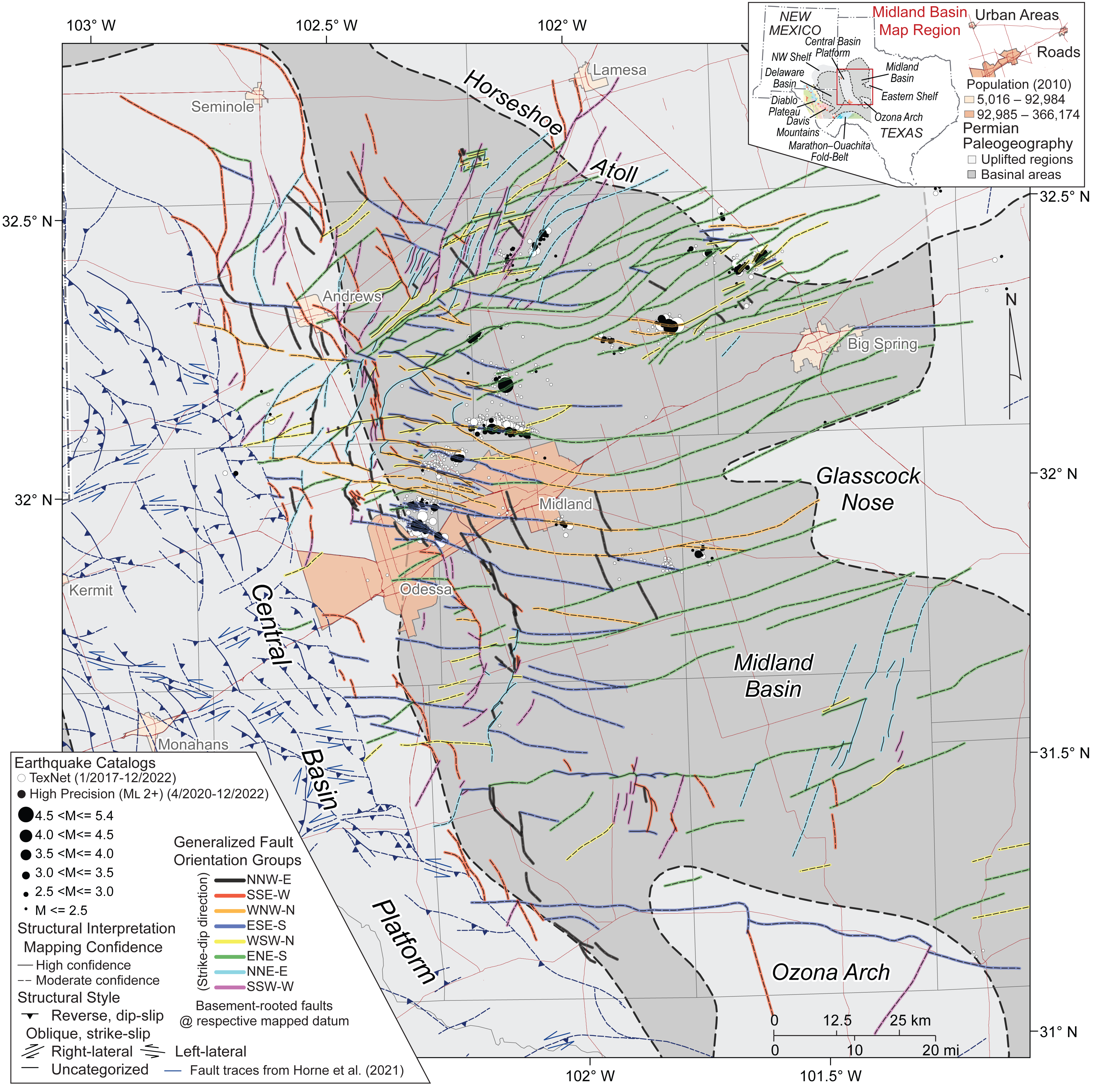
MB1: Index map highlighting the distribution of basement-rooted faults as expressed at the respective interpretation datums mapped across the Midland Basin. Faults are colored according to orientation group. Cardinal direction abbreviations used to define orientation groups follow (strike direction-dip direction): NNW-E = north-northwest striking fault that dips toward the east. Taken from Horne et al. (2024).
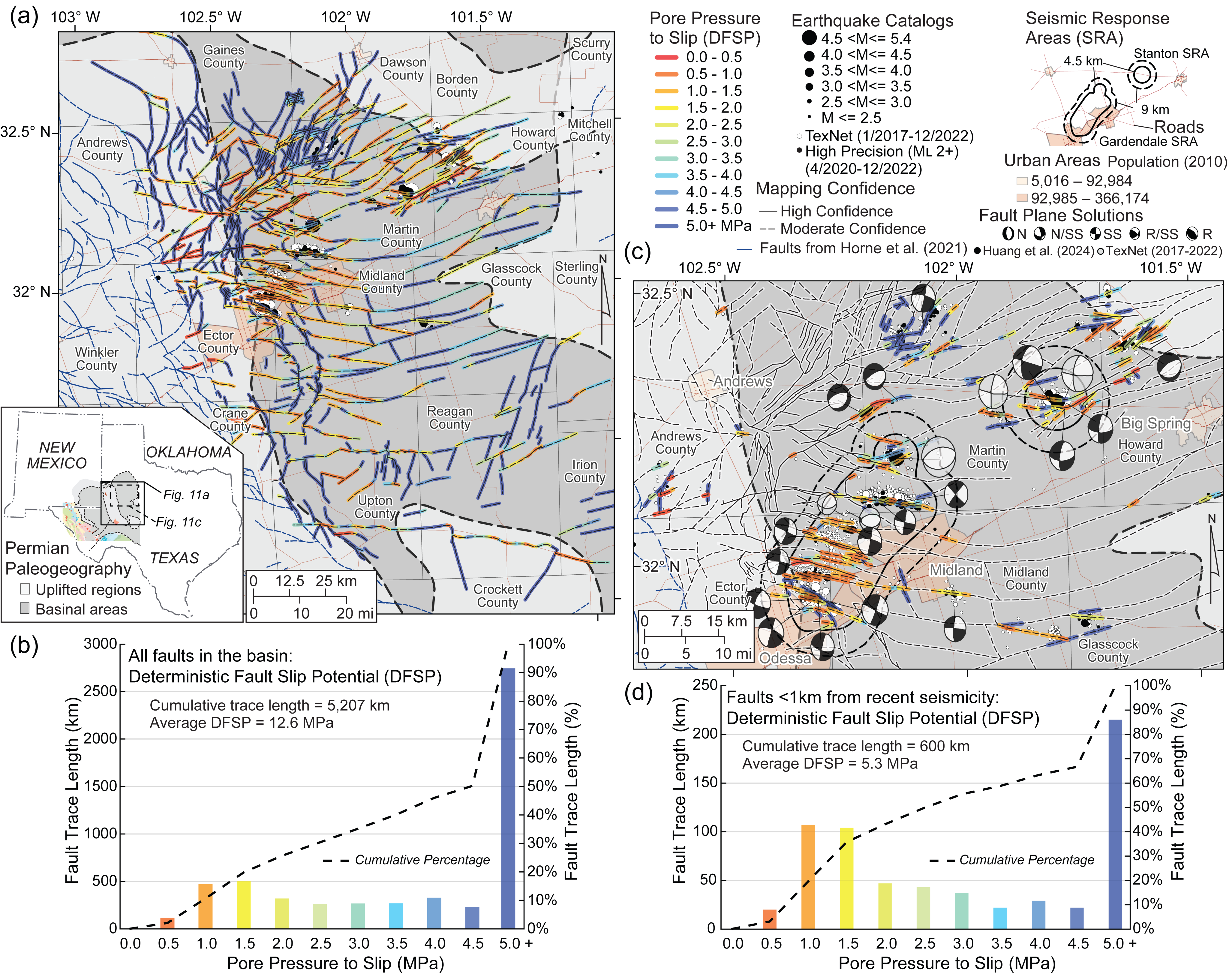
MB2: (a) Regional map of faults colored by deterministic fault slip potential (DFSP). Warm colors represent smaller ΔPp required to cause slip under in situ stress conditions (sensitive faults), cool colors represent larger ΔPp required to cause slip (insensitive faults). (b) Histogram highlighting distribution of DFSP shown in (a). (c) Inset map and (d) histogram of DFSP values for seismogenic faults. Fault plane solutions shown in (c) are taken from the “Texas Seismological Network Earthquake Catalog” (2021) and Huang et al. (2023, 2024). Fault plane solution abbreviations include N= normal; N/SS= normal–strike-slip; SS= strike-slip; R/SS= reverse–strike-slip; and R= reverse. Taken from Horne et al. (2024).