The Eagle Ford shale play of Texas experienced an increase in the rate of felt seismicity from 2014-2019, temporally coincident with hydraulic fracturing (HF) operations. By mid-2019, the rate of seismicity decreased alongside a reduction in the rate of well completions, thus prompting this investigation of the relationship between HF operations and geologic conditions that contribute to induced earthquake hazards. The goals of this work included mapping and conducting a geomechanical characterization of faults that delineate seismogenic regions of the Eagle Ford to understand the conditions that lead to inducing fault rupture. An integrated regional dataset composed of published data, wells, earthquakes, and interpretations from operators provided input for a 3D structural framework. Earthquake relocation analyses helped constrain the distribution of earthquakes that correlate to interpreted faults and enable identification of those that have been seismogenic. In-situ stress state of faults was analyzed to determine fault sensitivity. A spatiotemporal analysis of HF operations and earthquakes further revealed induced-earthquake clusters that are linked to specific faults. We show how seismogenic and aseismogenic fault systems relate to earthquakes by determining which faults are more sensitive and which faults have been seismogenic. Faulting is dominated by NE-SW striking normal faults with 21% having hosted induced earthquakes since 2017. Faults in the Eagle Ford region have a geologically quasi-stable in situ stress state. Using a conservative scheme, we directly associate 45% of earthquake ruptures to HF to build our analysis dataset. Of those events, 70% are located within 1 km of a mapped fault. Stress conditions on seismogenic faults show a wide range of sensitivity to rupture. This suggests that all faults close to HF operations should be considered as candidates likely to rupture.
McKeighan, C., P. Hennings, E. A. Horne, K. Smye, and A. Morris (2022). Understanding Anthropogenic Fault Rupture in the Eagle Ford Region, South-Central Texas, Bulletin of the Seismological Society of America, 20 pp., doi: https://doi.org/10.1785/0120220074
Downloadable Data
Faults associated with this research are publicly available within the Texas Data Repository and can be accessed through the Digital Object Identifier (DOI) system with DOI: 10.18738/T8/TOPKV4
Eagle Ford hypoDD relocation catalog and CMTs for Li et al., (2021) “Characteristics of Seismicity in the Eagle Ford Shale Play, Southern Texas, Constrained by Earthquake Relocation and Centroid Moment Tensor Inversion” are archived at the Texas Data Repository: https://doi.org/10.18738/T8/GHNC9P.
All existing data we use can be accessed through the respective journal citation. Supplemental figures and tables included in the Supplemental Material.
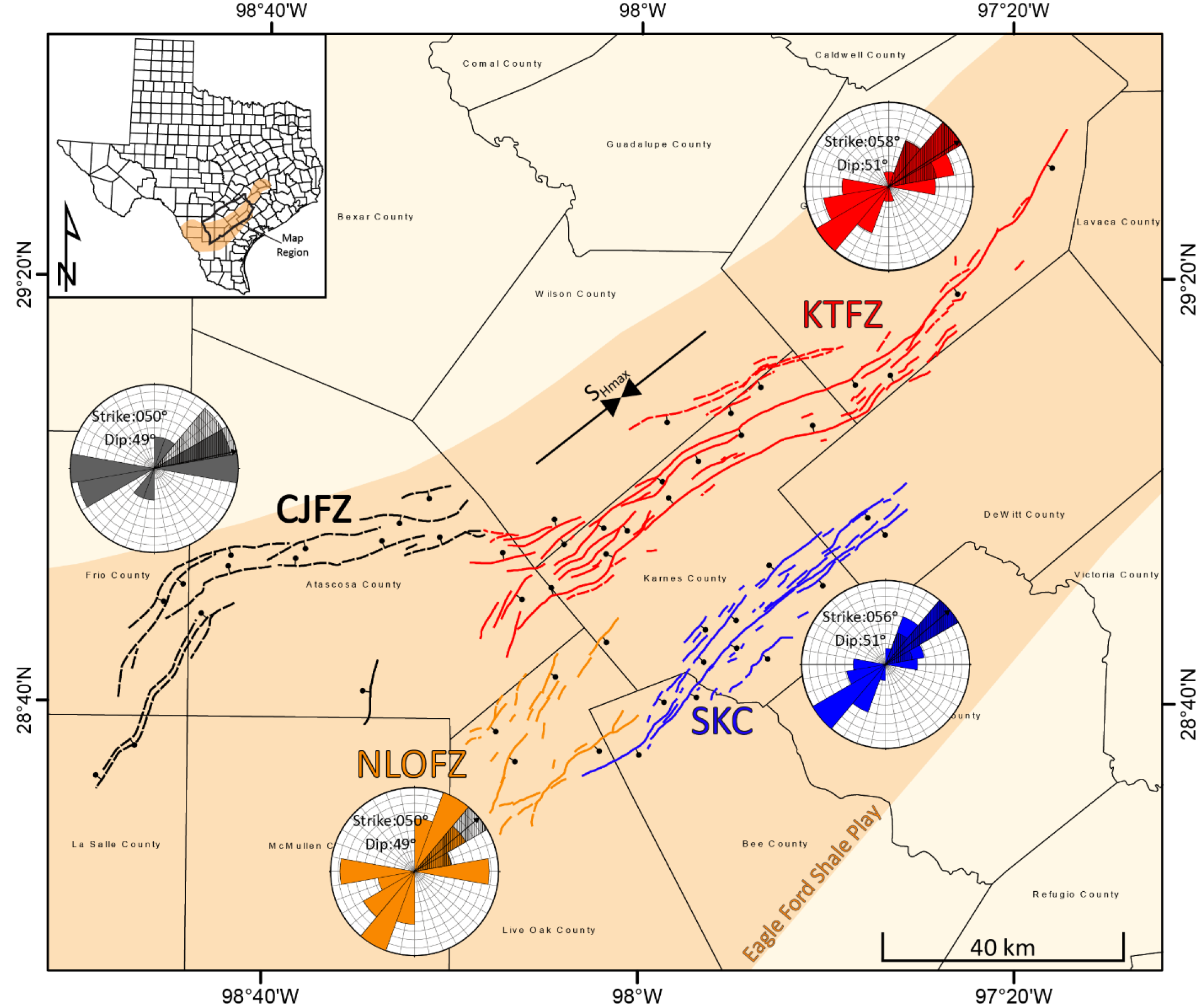
EF1: Interpreted faults colored by region. Solid lines indicate faults with a high-confidence interpretation and dashed faults are moderate confidence. Rose diagrams representative of each fault area (colored) and represent mean fault strike and dip for each region. SHmax is 52°. Regions: Karnes Trough Fault Zone (KTFZ), Charlotte-Jourdanton Fault Zone (CJFZ), Northern Live Oak Fault Zone (NLOFZ), Southern Karnes County (SKC). Taken from McKeighan et al. (2022, in review).
Dataset & interpretation confidence
An integrated regional dataset composed of published data, >13,000 wells, earthquakes, stress data, earthquake focal mechanisms (Lund Snee and Zoback, 2020; Li et al. 2021) and interpretations from operators provided input for a 3D structural framework.
References
McKeighan, C., Hennings, P.H., Horne, E.A., Smye, K.M., and Morris, A.P., 2022 – in review, Understanding Anthropogenic Fault Rupture in the Eagle Ford Region, south-central Texas: Bulletin of the Seismological Society of America, v. XX, p. Y.
McKeighan, C., Hennings, P.H., Horne, E.A., and Smye, K.M., 2021, 3D Interpretation, Structural Characterization, and Seismogenic Association of Faults in the Eagle Ford Region, South-Central Texas: GCAGS Transactions, v. 71, p. 185–191, GCAGS Archives.