 |
2005 mid-year report |
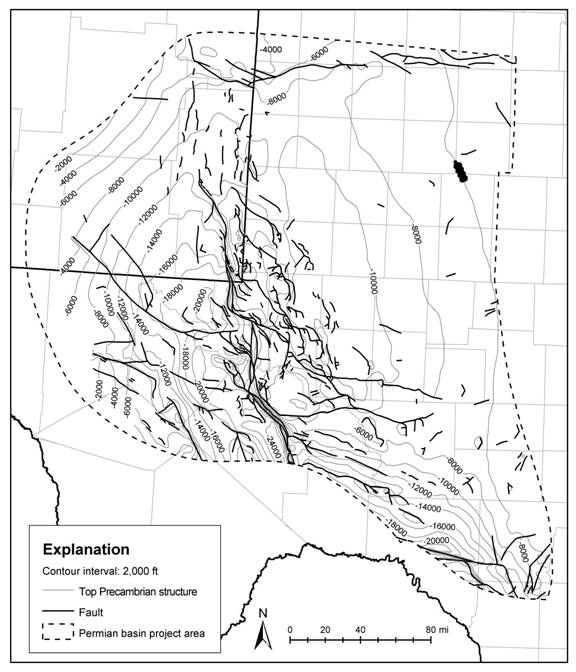
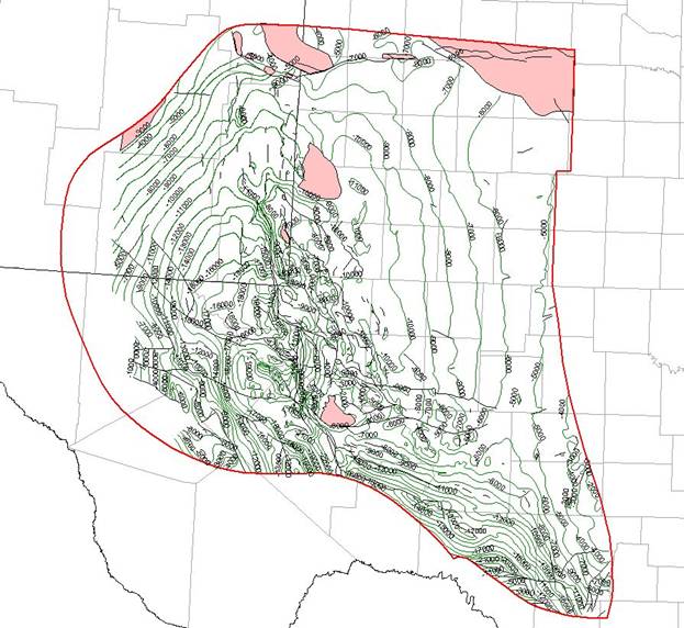
Update on Permian Basin Geological Synthesis Project (PBGSP) We have made considerable progress on the project. As you will recall, project activities for the first year of the project fall in two basic areas: (1) preparation of a comprehensive written synthesis of the geology of oil-producing plays in the Permian Basin, and (2) collection of data and construction of a GIS database for selected plays. Progress on Written Synthesis Twenty-two chapters or sections are being prepared. Each will average about 20 pages of text and about 15 figures. Total document length will be about 600–700 pages. Draft chapters of this synthesis volume have been completed or are nearing completion on five important reservoir systems: the Middle Ordovician Simpson Group, the Upper Ordovician Montoya Group, the Ordovician -Silurian Fusselman, the Upper Silurian Wristen Group, and the Lower Devonian Thirtyone Formation. In addition, work is well underway on the following chapters: the Pennsylvanian System (Atoka, Morrow, Strawn, Canyon, Cisco), Leonard platform, Upper Permian Yates Formation, Queen formation, and Delaware Mountain Group. Progress on GIS DatabaseAs outlined at the beginning of the study, our initial efforts on database construction are on the Thirtyone, Woodford, and Barnett Formations. The project area encompasses parts of about 45 counties (Figure 1). Work is well underway on assembling a regional wireline log database from which cross sections, type logs, thickness maps, and structure maps will be prepared. We are in the process of identifying approximately 50 wells per county or about 2,000–2,500 wells across the project area. In addition, however, we have created GIS project data layers for the following additional play and depositional and structural horizons in the basin: (1) structure map and stratigraphic tops for the Precambrian basement, (2) structure maps and stratigraphic tops for the Ellenburger Group, (3) isopach maps for the Simpson, Montoya, and Silurian-Devonian intervals, (4) structure maps and stratigraphic tops for the Woodford Formation, and (5) contour maps and data on geothermal gradient. It's significant to note that the map of Precambrian basement (Figure 1) is the most detailed map of Permian Basin basement structure ever produced as well as the first digital, spatially-registered GIS map of this surface ever available. Also significant is our GIS map of the structure of the basin at the top of the Ellenburger Group (Figure 2). This map, which is derived from The Tectonic Map of Texas (Ewing, 1990), is the first digital basin structure map of this detail. We have also produced a map of the distribution of geothermal gradients in West Texas; this work was made possible through separate funding. We have also begun to build additional data access files into the project like an available core file. We have so far identified about 6500 cores at Bureau facilities that penetrate Permian Basin reservoir units. These are being located and identified so that they can be accessed in the GIS project and utilized in future reservoir studies. Staff UpdateTo increase our effort and expertise on the project, we have added new staff to the team. Dr. Wayne Wright (new with the Bureau) has specific experience in Carboniferous depositional systems worldwide. His early focus on the PBGSP is a synthesis of the Pennsylvanian System. Dr. Edgar Guevara (18 years of experience at the Bureau and more than 35 years of experience in clastic reservoir systems worldwide) has started work on a synthesis of the basinal Dean and Spraberry successions in the Midland Basin and will also work the Delaware Mountain Group in the Delaware Basin. Seay Nance (22 years experience at the Bureau) is working on upper Guadalupian platform and basins successions (e.g., Queen, Yates, Delaware Mountain Group). A list of project staff is appended at the end of this report. Funding and Program Updates Additional funding has been obtained from the State of Texas to increase manpower and effort on the project. The specific focus of this funding, which will run at least one year, is to expand the scope of studies on the Barnett and Woodford shale plays across the entire region. We have reached an agreement in principal to utilize data and maps from Geological Data Services (GDS, Addison, Texas) to illustrate regional features for our written syntheses and to guide work in focused play studies. GDS has an extensive inventory of formation tops from more than 230,000 wells in the Permian Basin study area. We will compare and interrelate their data with ours making it possible for our findings to be integrated with GDS tops, cross sections, and maps. We are working with WesternGeco to arrange similar access to Western's multi-client 3D data across the Permian Basin. Integration of our data with theirs would provide interpretive guidelines and insights for using WesternGeco 3D data in the Basin. Future Activities Work on the written synthesis and GIS database will continue through the year. We would like to hold a sponsors meeting/workshop early next year to disseminate results of the project during 2005. As discussed at startup meetings, our concept for the meeting is to center it around core and poster displays of important reservoir successions. These would be preceded by summary oral presentations on the accomplishments of the project and overviews of the plays and depositional successions. We are interested in hearing from you about your interest in such a meeting and we welcome specific requests and comments on the focus of the meeting (in terms of materials and content). We have also begun a regional synthesis of the tectonic evolution of the Basin. This analysis will provide a stronger basis for interpreting Pennsylvanian depositional styles and reservoir development and distribution as well as forming laying the groundwork for a better understanding of structural controls on reservoir development across the Basin. Request for Input on Data and Focus As we discussed with you at the startup meetings, we are always interested in getting your input on project scope and direction. To this end we are open to ideas and current interests you have. We are also interested in obtaining any cores, logs and other data that you can contribute that would improve the accuracy of the project and help with your focused studies. Contact me at any time if you have data to contribute or questions or comments. Project Team: Steve Ruppel: Project leader Robert Loucks: Co-PI Charles Kerans Wayne Wright Edgar Guevara Seay Nance Rebecca Jones Ted Playton Graduate Students (2)
Figure 1. Map showing study area and structure on Precambrian basement. Contours are feet below mean sea level. Faults from Ewing (1990). Dashed line shows project study area. Exported from ARC-GIS.
Figure 2. Map of Ellenburger structure in project study area. Contours are feet below mean sea level on the top of the Ellenburger. Exported from ARC-GIS. |