Platform-Interior Carbonate Depositional Environments
Robert G. Loucks, Scott Rodgers, Charles Kerans, and Xavier Janson
Bureau of Economic Geology
 
Design Objectives
Credits
Back
Top
Exit


Tidal-Flat Depositional Environments

Shinn (1983) stated that tidal-flat facies tracts are composed of three basic depositional environments.


Environmental Zones
 

The supratidal zone is above high tide and is flooded only at spring tide or during storms. The zone between mean high tide and mean low tide is the intertidal zone. It is exposed twice daily. The subtidal zone is below mean low tide and is rarely, if ever, exposed.


Characteristics of these environments reflect whether tidal flats were deposited under humid or arid conditions. We first discuss the "Humid Tidal-Flat Facies Tract.”


Humid-Tidal-Flat Facies Tract

The humid-climate tidal flat is characterized by ponds and marshes that contain well-developed algal mat communities and numerous tidal channels that act as principal sedimentation agents on the flats. The aerial photograph and associated cross section are an excellent example of a modern humid-tidal flat.

 
Aerial photograph and associated cross section of the humid-tidal-flat complex behind North Caicos Islands in the Turks and Caicos. See representative cross section below.
 
Cross section A–A' of the humid-tidal flat presented above.

Major environmental zones


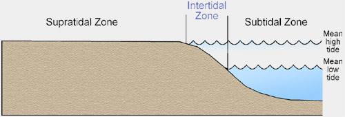
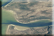
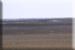
Supratidal environment
is where sediment is deposited above normal high tide by spring and storm tides. The sediment is exposed for long periods to subaerial conditions.

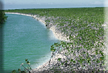
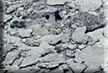
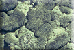
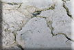
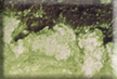
Diagnostic supratidal sedimentary structures include mud cracks; fine laminations; algal mats and domes; bird’s-eye or fenestrae structures; plant, animal, and insect burrows; intraclasts; and dolomite crusts.

Rock types include laminated mudstones to wackestones, algal boundstones (stromatolites), intraclast conglomerates, and rare storm-deposited grainstones. These rock types are commonly dolomitized.

Intertidal environment is where the sediment is deposited between normal high tide and normal low tide. The sediment in this zone is generally exposed twice a day to subaerial conditions at low tide. Tidal channels are common in this zone.

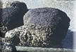
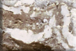
Diagnostic intertidal sedimentary structures include fine laminations, algal mats and algal heads, crab and mollusk burrows, and thin rippled sands.

Rock types include burrowed to laminated mudstones to wackestones, algal boundstones with algal heads (stromatolites), thin crossbedded grainstones, and rare storm-deposited grainstones.

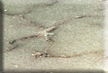
Subtidal environment occurs immediately seaward of the normal low-tide mark or in a tidal channel dissecting the flats and is rarely exposed to the subaerial environment.

The diagnostic subtidal sedimentary structure is bioturbation.

Rock types include bioturbated wackestones to mud-rich packstones. Peloids are a common grain type.


Photographs of Modern Humid-Tidal Flats

CLICK ON THUMBNAILS BELOW FOR LARGER VIEW AND MORE INFORMATION.
Oblique air photograph of the southern edge of the humid-tidal flats behind the Northern Caicos Islands.
A tidal channel cutting through the supratidal-flat mud. The bottom of the channel is floored by mollusk and algal grains and rare corals in the more open-marine sections of the channel. Northern Caicos Islands.
Flat-pebble conglomerate (mud intraclasts), low-energy beach on the edge of the tidal flats. The flat pebbles are produced by storms ripping up semilithified mud. Northern Caicos Islands.
Soft supratidal-flat mud showing a mud-cracked surface. Plants are red mangroves. Northern Caicos Islands.
Puscular algal mat (cyanobacteria) forming on the supratidal flat. West Caicos Island.
Cross-section view of the algal mat showing dark algal layers and lighter colored lime-mud layers. West Caicos Island.
Mud cracks produced by exposure on the supratidal flats. Northern Caicos Islands.
Stromatolite heads with rippled sand between algal heads in the intertidal zone of Shark Bay, Western Australia.
 
 
Arid-Tidal-Flat Facies Tract (Sabkha)

The arid equivalent of the humid-tidal-flat environment will have many of the same features as humid-tidal flats, but they will also contain evaporite minerals (gypsum and/or anhydrite) in the form of nodules or contorted bedding (enterolithic structures). In the ancient record they are generally dolomitized. Tidal ponds and marshes are rare, and the well-defined zones of algal mats are only along the shoreline, within the intertidal environment. Tidal channels are not as common as in the humid-environment equivalent (Shinn, 1983).

Rock types will be basically the same textures, but will also contain nodules, laminae, and beds of evaporite minerals.


Photographs of Modern Arid-Tidal Flats

CLICK ON THUMBNAILS BELOW FOR LARGER VIEW AND MORE INFORMATION.
Photograph from space of the Abu Dhabi Trucial coast arid-tidal flats.
Flat surface of the Trucial coast arid-tidal flat covered by algae.
Trench in the Trucial coast tidal flat showing nodular anhydrite (white mineral).
Trench in the Trucial coast tidal flat showing enterolithic anhydrite (white mineral).
Pressure ridges of evaporite expansion in a flooded evaporitic salt pond on arid-tidal flat.
Salt polygons on a dry arid-tidal flat.


Photographs of Ancient Tidal Flats

CLICK ON THUMBNAILS BELOW FOR LARGER VIEW AND MORE INFORMATION.
Supratidal mud-cracked mudstone.
Ancient algal stromatolite bindstone.
Supratidal algal laminated mudstone.
Supratidal algal laminated mudstone with mud cracks.
Thin section of ancient algal mat showing “birds-eye structure.”
Lower Eocene sabkha composed of interlaminated algal mudstone and anhydrite from Tunisia. Darker layers are lime mudstone and lighter layers are anhydrite.
Lower Eocene sabkha mudstone with evaporite nodules (white mineral) from Tunisia.
Supratidal sabkha nodular evaporite (white areas are anhydrite) within dolomitic mud (dark areas). Upper Jurassic Smackover Formation in South Texas.
Supratidal sabkha crust with clasts, roots, or insect burrows, and “cats-eye” gypsum crystals. Lower Cretaceous Edwards Formation in North-Central Texas.

NEXT


© 2003 American Geological Institute and American Association of Petroleum Geologists. All Rights Reserved.