VENTURA-SANTA BARBARA-JALAMA BEACH-GREFCO QUARRY/LOMPOC
Peter Eichhubl
Department of Geological Sciences, Stanford University, CA 94305
Richard J. Behl
Department of Geological Sciences, California State University Long Beach, CA 90840
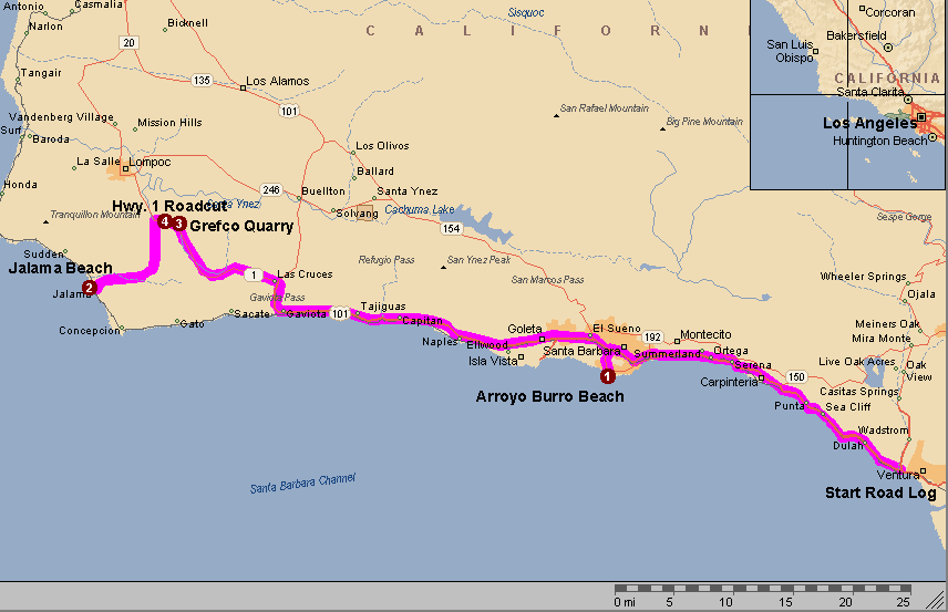
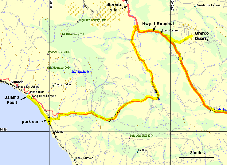
The road log starts at the junction of Hwy 33 and U.S. Hwy. 101 in Ventura (mileage 0). Turn north on Hwy 101 towards Santa Barbara. MAP
INTRODUCTION TO THE SANTA BARBARA-VENTURA BASIN
The Tertiary sequence of the Santa Barbara-Ventura basin reflects a highly structured depositional environment that is the result of a tectonically dynamic setting of the southern California continental margin. The sequence, which locally exceeds 10 km (30,000 feet), is characterized by an alternation of mud- and sandstone units of submarine fans and interlobe deposits, gradually filling the east-west trending Paleogene basin with continent derived clastic sediment. By late Eocene time in the Ventura basin and early Oligocene time in the central Santa Ynez Mountains, marine deposition was followed by non-marine alluvial deposition of the Sespe Formation, whereas shallow marine deposition of the Gaviota Formation continued in the western Santa Ynez Mountains. Tectonic reorganization of the Pacific-North American plate boundary initiated a phase of renewed subsidence and deposition of marine strata during late Oligocene-early Miocene time. Separation of sub-basins from continental clastic input by intrabasinal sills provided isolated conditions for the deposition of organic-rich siliceous hemipelagic mudstone of the Monterey Formation between about 18 and 6 Ma. An increase in terrigenous detrital input marks the onset of Sisquoc deposition in late Miocene time, followed by the locally more than 3 km (10,000 feet) thick turbidite sequence of the Plio-Pleistocene Pico Formation. Uplift and exhumation of the Santa Ynez Mountains at about 1 Ma is marked by the deposition of coarse clastic units in the Ventura, Carpinteria, and Santa Barbara coastal area.
EN ROUTE: RAPID TECTONIC SHORTENING AND ELEVATED PORE FLUID PRESSURE IN THE RINCON-VENTURA ANTICLINORIUM
West of Ventura, Hwy. 101 follows a 1-5 Ka old marine terrace, cutting obliquely across the E-W trending anticlinorium of the Ventura Avenue oil field and its western continuation, the San Miguelito, Rincon, and Dos Cuadras oil fields. The combined production of these oil fields exceeds 1.5 billion barrels (Conservation Committee of California Oil and Gas Producers, 1991), produced from the turbidite sands of the Plio/Pleistocene Pico Formation. Radiometric ages from interbedded ash beds and amino-acid ages from uplifted marine terraces indicate that folding of the Ventura Avenue anticline started about 0.2 Ma ago, with initial uplift rates as high as 15 mm/yr and an average horizontal shortening rate of about 2 cm/yr.
The high rate of tectonic shortening across the Rincon-Ventura anticlinorium is presumably responsible for tilted oil-water contacts in the reservoirs and elevated pore fluid pressure, reaching pore pressure gradients of up to 0.9 psi/ft (McCulloh, 1969). Elevated pore fluid pressure in the offshore Dos Cuadras field contributed to the blow-out of platform A in 1969.
Striking evidence for rapid uplift is provided by a 45 Ka old marine terrace deposit, well exposed along Hwy. 101 between Sea Cliff and Punta Gorda. The terrace deposit lies in angular unconformity on steeply dipping Pico Formation and sits about 120 ft above sea level at Punta Gorda, rising to an elevation of about 800 ft near Ventura. The artificial Rincon island marks the crest of the Ventura Avenue-San Miguelito-Rincon-Dos Cuadras anticlinorium. The north limb of this anticlinorium is truncated by the east-west trending Red Mountain fault which crosses Hwy. 101 between the little town of La Conchita and Rincon Point. The north-dipping Red Mountain fault thrusts the Paleogene sequence over the Plio-Pleistocene Pico Formation. A subparallel fault, the Carpinteria fault, forms a north-facing fault scarp south of Hwy. 101 just east of Carpinteria, apparently offsetting the 45 Ka old marine terrace.
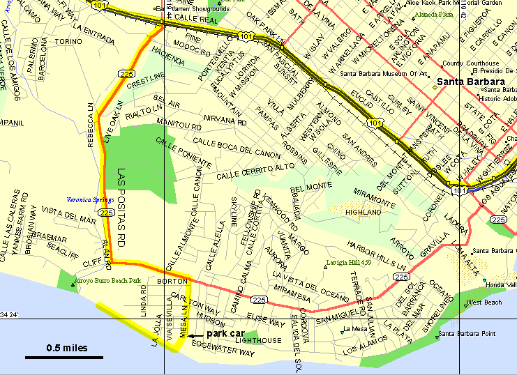
In Santa Barbara, take Las Positas Exit (Hwy. 225) of Hwy. 101 (31.4 miles from Ventura), turn left (south) across the freeway and the rail track, go straight across Modoc Road, and follow Las Positas Rd. 1.8 miles to the T intersection with Cliff Drive. Turn left on Cliff Drive (Hwy. 225), and right onto Mesa Lane at the first stop light (0.5 miles after Las Positas Rd.). Park on street at the end of Mesa Lane. A public walkway and stairs lead down to the beach. Alternatively, the beach section can be reached from Arroyo Burro County Beach Park: At the T intersection of Las Positas and Cliff Drive, turn right onto Cliff Drive, continue for 0.2 miles, and turn left into the beach parking lot. Walk east along the beach for about 0.8 miles to the stairs leading down from Mesa Lane. MAP
STOP 1: ARROYO BURRO BEACH (Mesa Lane to Arroyo Burro County Park)
KEY POINTS:
- Sequence of veins correlates with host rock burial diagenesis and provides insight into basinal fluid evolution and fluid expulsion
- Evolution of fracture-controlled fluid flow from bedding-scale fractures to outcrop-scale faults
- Control of rock type on style of brittle deformation
CAUTION: Be aware of the risk of rock falls from the cliffs, in particular immediately to the west of the stairs and during periods of high wind and after rain fall.
Access is limited to low tides--check http://www.co-ops.nos.noaa.gov/tide_pred.html for tide prediction prior to visit.
Stratigraphic and structural overview
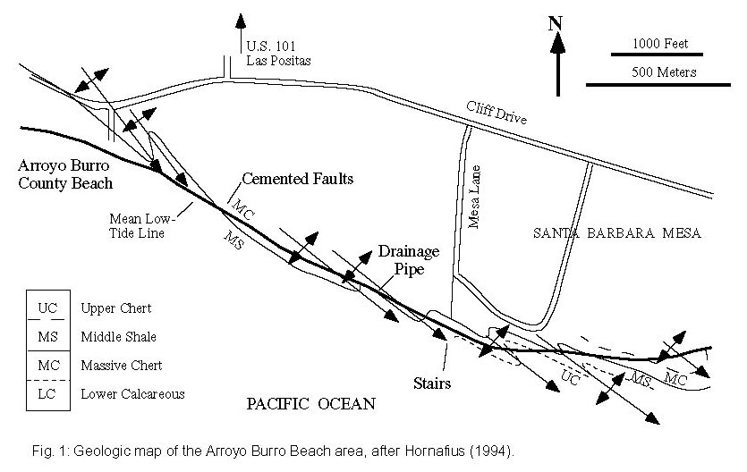
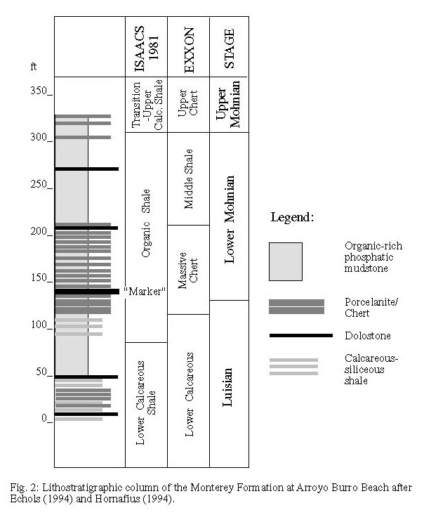
The cliffs between Mesa Lane and Arroyo Burro County Beach expose the Organic Shale member of the Monterey Formation (Hornafius, 1994), following Isaacs' (1981a) subdivision of the Monterey Formation (Figure 1). The steeply dipping section forms the southern limb of the Mesa anticline (see Figure 1 of Gross and others, this volume), a monoclinal structure (Olson, 1982) bound by the Mesa and Lavigia faults to the north (Dibblee, 1966, 1986a) and the E-W striking Santa Barbara fault system to the south (Hoyt, 1976). Outcrop scale folds exposed along the beach section, with axes trending WNW-ESE, are second and third-order parasitic folds with respect to the anticline. The Mesa anticline produced 3.7 million bbl of 20-24 API gravity crude oil from the Late Oligocene Vaqueros Formation between 1930 and 1970 (Conservation Committee of California Oil and Gas Producers, 1991).
A distinct, ~0.5 m thick bed of siliceous dolostone, folded to an anticline at the beach level 150 m west of the Mesa Lane stairs, is about 3 m above the Luisian/Mohnian stage boundary based on benthic foraminifera (Echols, 1994; Hornafius, 1994; Figure 2). The Luisian/Mohnian stage boundary corresponds to 13.8 Ma (Barron, 1986). Folding and faulting exposes the dolostone marker repeatedly along the beach transect (Hornafius, 1994) which cuts the section at an highly oblique angle with respect to the strike of the units (Figure 1).
Diagenetic alteration and burial history
The section immediately west of the stairs exposes a porcelanite-rich section ('Massive chert' of Hornafius, 1994) of the Organic Shale member in the lower 10 m (30 feet) of the cliffs, overlain by less siliceous, organic-rich phosphatic mudstone. Porcelanite beds are in the opal-CT diagenetic stage (Gross, 1993, 1995), whereas silica contained in the dolostone beds is partially recrystallized to quartz. Organic-rich mudstone has remained in the opal-A diagenetic stage (Gross, 1993, 1995). The difference in silica diagenetic alteration stage reflects the dependence of silica diagenesis on detrital content as demonstrated by Isaacs (1981b, 1982). Based on the correlation between silica diagenetic grade and burial temperature of the Monterey Formation by Keller and Isaacs (1985; also see Behl, this volume), the Arroyo Burro Beach section has experienced maximum burial temperatures of about 45-50°C.
A burial reconstruction (Eichhubl and Boles, Figure 2, this volume) suggests that a maximum burial depth of about 750 m was reached at about 1 Ma. Evidence for exhumation at 1 Ma is provided by the erosional base of the Santa Barbara Formation on Santa Barbara Mesa, unconformably overlying the Miocene sequence (Olson, 1982; Dibblee, 1966, 1986a). Deposition of the coarse clastic Santa Barbara Formation reflects the exhumation and erosion of the Santa Ynez Mountains (Jackson and Yeats, 1982). The Arroyo Burro Beach section underwent a short second burial cycle during deposition of the Santa Barbara Formation, and renewed exhumation during uplift of the 'Mesa'.
Proceed west along the beach for about 160 m to a mine addit. The section west of the addit is 'Station A' of Gross and others (this volume).
Lithology-control of brittle deformation: Fracture partitioning and fault-fracture meshes
The alternating sequence of opal-CT porcelanite and opal-A organic-rich, phosphatic mudstone demonstrates the effect of rock type on fracture style. Porcelanite beds, as well as dolostone higher up the cliff, preferentially fail by extension fractures that are perpendicular to bedding, whereas organic-rich mudstone accommodate extension by small-scale normal faults. Larger normal faults cut across both porcelanite and mudstone, ending in bedding-parallel detachment surfaces. Gross and others (1997; this volume) measured the displacement as a function of fault length of normal faults in this sequence. Displacements of normal faults that extend beyond single mudstone beds were found to be larger than predicted based on a linear length-displacment correlation for bedding-confined faults, due to secondary faulting and interaction of normal faults with bedding-parallel detachments.
In a similar sequence 450 m west from here (Station 7 of Gross and others, this volume), now covered by a landslide, Gross and Engelder (1995) measured the extensional strain as accommodated by normal faults and extension fractures in all three rock types--dolostone, porcelanite, and mudstone. All three rock types were apparently equally extended by about 10%, suggesting that both types of extensional failure occurred contemporaneously. The difference in failure mode, extension fracture in dolostone, shear failure in mudstone, was explained by Gross (1995) by differences in the ratio of vertical to horizontal stress and by a higher uniaxial compressive strength of dolostone as compared to mudstone. For a uniform vertical stress given by the overburden weight, dolostone may support a larger differential stress than mudstone, thus reaching tensile failure conditions while mudstone fails in shear.
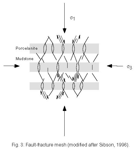
The connected system of minor faults and extension fractures has been termed fault-fracture mesh by Sibson (1996) after Hill (1977) (Figure 3). Sibson (1996) suggested that fault-fracture meshes may provide important conduits for basinal fluid migration. Fluid flow would occur preferentially parallel to bedding within the extension fractures, whereas flow across bedding is likely to be impeded by the lower permeability along the connecting shear fractures as compared to the extension fractures. Fault slip along these shear fractures, however, would provide a mechanism of re-opening the extension fractures which may otherwise seal up due to mineral precipitation. Evidence for fluid migration parallel to bedding will be further discussed at the Jalama Beach, stop 2. Based on observations by Hill (1977), Sibson (1996) suggested that fluid migration along fault-fracture meshes may result in the spatially diffuse occurrence of smaller earthquakes, observed as earthquake swarms. Earthquake swarms were recorded in the Santa Barbara channel in 1968 (Sylvester and others, 1970) and in 1984 (Henyey and Teng, 1985; Shaw and Suppe, 1994).
Proceed west along the beach for about 100 m, past the prominent anticline, to an aluminum drainage pipe leading from the top of the bluffs down to the beach. In both fold limbs, notice symmetric, disharmonious chevron folds of 20-30 cm amplitude in thin bedded, laminated chert with porcelanite interlayers, whereas over- and underlying opal-A mudstone accommodated shortening by layer-parallel bulk shortening.
Multiple vein generations reflecting burial diagenesis and pore fluid evolution
Eichhubl and Boles (this volume) distinguish four different generations of veins at this location based on vein cement composition and structural context (Table 1). All four vein generations are characterized by fragmentation of the host rock (Elliot, 1990), forming 'breccia dikes' and 'sills'. Each generation represents repeated episodes of fracturing and partial or complete cementation. The first three vein generations are observed in the siliceous dolostone beds and are well exposed in the dolostone marker bed below and to the west of the aluminum drainage tube.
Veins of the first generation are cemented by laminated, in part siliceous, dolomicrite. Veins are oriented preferentially perpendicular and parallel to bedding, with bedding-perpendicular veins striking E-W (Figure 3 of Eichhubl and Boles, this volume). Bedding-perpendicular veins are laminated parallel to the vein margin. Truncations and cross-cutting of laminae indicate multiple stages of vein opening and infill, presumably corresponding to multiple episodes of fluid flow. Locally, micrite is stratified parallel to the bedding of the country rock indicating vein fill prior to folding of the section (Plate 1a). The heavy carbon isotopic composition of the dolomite vein cement, with del13CPDB values of up to +15%o, suggests dolomite vein precipitation in the zone of bacterial methanogenesis during shallow burial (Figure 4; Eichhubl and Boles, this volume).
The second vein set, cemented by quartz, forms bedding-parallel breccia zones that are confined to quartz-rich layers of the dolostone marker bed, and are well exposed ~20 m west of the tube. Fragments of siliceous dolostone host rock can be observed to be rotated with respect to bedding without any evidence for fragment transport beyond the hand sample scale. Quartz cementation of these veins accompanied opal-CT to quartz transformation in the dolostone host rock.
The third vein set, cemented by baroque dolomite and minor amounts of dolomicrite, forms breccia bodies in dolostone along low-angle reverse faults or reactivating earlier quartz breccias. Dolomite cementation of the breccia accompanied dolomite recrystallization of the host dolostone. The stable isotopic composition is characterized by del13CPDB values around +4 to +9%o, distinctly lighter than first generation dolomicrite veins, and del18OPDB values of -6 to -7.5%o (Figure 4; Eichhubl and Boles, this volume). These values apparently reflect increasing burial and an increased component of thermogenic methane.
The fourth vein set, cemented by calcite, is found in three types of structural context. 1.) Laminated, up to 7 cm thick calcite veins form perpendicular to bedding in dolostone, in part reactivating early dolomicrite veins. Lamination is due to alternating layers of columnar and micritic calcite rather than due to crack-seal opening increments (Plate 4e). Tail cracks and breccia-filled rhombochasms indicate reactivation of some veins in shear, leading to host rock brecciation. Calcite vein cement is also found along earlier low-angle thrusts and reactivating earlier dolomite and quartz breccias. These calcite veins are well exposed in the dolostone marker bed below and to the west of the aluminum tube. 2.) Calcite veins are found as bedding confined sets in porcelanite layers that are interbedded in organic-rich mudstone. The calcite veins may splay and extend into the mudstone layers for a few centimeters. Frequently, the extensional strain of these calcite cemented veins is accommodated by normal faulting in the under- and overlying mudstone. Good exposures of bedding confined calcite veins are found on the wave-cut platform during minus tides and low sand levels to the southwest of the aluminum tube. 3.) Calcite veins, petrographically and compositionally similar to the bedding confined veins, are extensively developed adjacent to two faults to be seen cutting across the cliff faces 400 m west of the aluminum pipe and further discussed below. Fourth-generation calcite veins at Arroyo Burro Beach contain abundant inclusions of solid organic matter (bitumen) and all-liquid aqueous fluid inclusions suggesting fluid temperatures of less than 65°C. Liquid hydrocarbon inclusions are rare and observed only in fault-related vein cement.
On the cliff exposure at this location, calcite veins are offset by conjugate brittle shear zones striking N040°E (dextral, e.g. 25 m west of tube) and N85°W (sinistral, e.g. 45 m west of tube), transecting the dolostone maker bed and the underlying mudstone. Brecciated host dolostone and calcite vein material is cemented by rock flour and bitumen.
The stable isotopic composition of fourth-generation calcite veins is quite distinct from the earlier dolomite veins. del18OPDB values of -5 to -6.5%o are heavier, and del13CPDB values of around +1%o lighter as compared to dolomite veins (Figure 4; Eichhubl and Boles, this volume). These values may reflect a mixed carbonate source, derived largely from dissolved calcite shell tests. Isaacs (1984b) found del18O values of foraminifera tests in the range of 0 to -6%o and del13CPDB values of -2 to -3%o. Dissolution of calcite tests is observed in the organic-rich mudstone hosting fourth-generation calcite veins. Calcite shell test dissolution also provides a likely source of calcium carbonate for vein cementation.
The observation of enhanced country rock alteration in breccias of all four vein generations cementation suggests that opening of the system by fracturing favored mass transfer and thus diagenetic alteration (Eichhubl and Boles, this volume). The burial diagenetic alteration, although enhanced by the presence of fractures, is not restricted to their vicinity, however, and thus not a contact alteration per se. Fractures rather act as catalysts for the transformation of metastable phases--opal-A, opal-CT, non-stoichiometric protodolomite, and organic matter--that are transformed to more stable phases under given conditions of temperature, pressure, and pore fluid composition (Eichhubl and Boles, this volume).
All four vein generations contain evidence for fluid movement such as sedimentary structures of detrital vein fill and rotation and translation of breccia clasts. Each vein generation, representing repeated episodes of fracture opening and cementation, likely corresponds to individual stages of fluid expulsion. The isotopic composition of vein cement, in conjunction with estimates of maximum burial temperatures from the silica diagenetic stage and fluid inclusions, provides some insight into the fluid isotopic evolution at Arroyo Burro Beach. The observed trend towards lighter del13C values and heavier del18O values from first to third generation dolomite veins most likely reflects increasing burial temperature and a change from bacteriogenic to thermogenic methane production. The later trend towards lighter del18O values during cementation of third generation dolomite and fourth generation calcite veins, while del13C values keep decreasing, may be the result of upward moving pore fluid, enriched in 18O. A likely source of 18O-enriched fluid are units undergoing dissolution of opal-CT at structurally deeper levels. Evidence for upward movement of pore fluid is seen in the strontium isotopic composition of third generation dolomite and fourth generation calcite cement (Eichhubl, 1997).
The evolution from bedding-confined fracture and breccia systems to meso-scale fault and fracture systems suggests an increase in scale of basinal fluid expulsion with time and a gradual opening of the system.
Proceed west along the beach for 500 m, past a second anticline and a landslide, to a small promontory adjacent to a tar cemented fault (about 600 m east of Arroyo Burro County Beach). The promontory may be largely covered by sand during the summer months. The anticline, trending N150°E, is again characterized by bitumen-cemented, brecciated chert folds within the anticline limbs, and by low-angle reverse faults containing dolomite-cemented breccias. The landslide obliterated most of Station 7 of Gross and Engelder (1995) and Gross and others (this volume).
Extensive calcite vein formation adjacent to faults
A prominent, calcite and bitumen cemented fault cuts across the cliff face, striking east-west and dipping 70° to the north. A second subparallel fault is exposed in the bluffs 110 m west of the promontory. The siliceous dolostone marker is found to the east of the first fault at beach level and apparently continues to the west of the first fault with ~10 m of apparent left lateral offset. Striated slickensides on the west side of the promontory indicate a subhorizontal fault slip vector on a subsidiary fault surface. These faults are extensively cemented with calcite vein cement and bitumen. Calcite forms radiating aggregates of bladed crystals, arranged in 10-30 cm thick botryoids which are brecciated along the fault planes and cemented by bitumen. Calcite vein cement is banded by alternating layers of light-colored inclusion-rich and darker-colored inclusion-poor calcite (Plate 4f).
The host-rock sequence of porcelanite and siliceous mudstone is densely transected by calcite veins, typically containing fragments of host rock. Details of the vein structure are best observed on the wave-cut platform when exposed after storms. Vein density gradually decreases over 30-50 m away from these faults (Figure 5). At larger distance away from the faults, these veins are identical with fourth-generation bedding-confined veins as discussed above. Within about 50 m of the faults, extension fractures are observed to cut across the porcelanite and mudstone sequence rather than forming fault-fracture meshes. These throughgoing extension fractures are widest in siliceous dolostone and porcelanite beds. They may splay and thin out when entering under- and overlying mudstone beds, and resume their orientation and thickness in the next under- or overlying porcelanite bed. Vein density is not only highest adjacent to faults but also in the vicinity of thicker veins (Figures 4 and 5 of Eichhubl and Boles, this volume). The clustering of subparallel extension veins ultimately lead to wall rock brecciation.
Brecciated veins cutting across the sequence would provide highly permeable conduits for fluid flow provided the rate of vein extension outpaces the rate of cementation. Idiomorphic crystal terminations of calcite vein cement suggests that the bulk of cement grew into open space. Only the latest cement stages show evidence for crack-seal increments (Plate 4d) indicating that the rate of fracture opening eventually fell below the rate of fracture cementation. Because the rate of cementation is likely to be a function of fluid composition and thus of burial diagenetic alteration, the timing of fracture formation and diagenetic alteration is critical. For fractures to serve as effective pathways for fluid flow, fracture formation has to follow diagenetic reactions of the country rock which could potentially seal the fracture system. The timing of fracture formation versus diagenetic alteration will be addressed again in context with silica cemented breccia systems (stop 3).
Return to the vehicles or continue along the beach, across the occasionally raging Arroyo Burro Creek, to Arroyo Burro County Beach to meet with your chauffeur. Take Cliff Drive and Las Positas Rd. back to U.S. Hwy. 101, turn left and take Hwy. 101 north. MAP
EN ROUTE: STRUCTURE OF THE WESTERN SANTA YNEZ MOUNTAINS
From the Santa Barbara-Goleta area to Gaviota, the freeway follows a Pleistocene marine terrace, subparallel to the strike of the uplifted Tertiary sequence of the Santa Ynez Mountains. The foothills of the Santa Ynez Mountains expose reddish sand- and siltstone of the Oligocene Sespe Formation, underlain by massive sandstones of the Gaviota-Coldwater and the Matilija Formations of Eocene age that form dip slopes facing south toward the basin. The Monterey Formation is almost continuously exposed along the beach cliffs. Coastal access with good exposures of Monterey Formation is found at Ellwood Beach west of Goleta (Bartlett, 1994) and from the state beaches along the freeway (Isaacs, 1981; Hornafius, 1994). West of El Capitan State Beach (20 miles from Las Positas Rd.), old pump jacks mark the site of the now inactive El Capitan oil field which produced ~13 million bbl of 19-23 API gravity crude from the lower Miocene Vaqueros Formation. The three offshore platforms of the Hondo-Santa Ynez oil field produce from the Monterey Formation. The drill rig about 0.5 miles east of the Gaviota processing plant targets the offshore Molino gas field. [note 02/2004: The pump jacks as well as the Moleno drill rig have been removed]
At Gaviota, the freeway turns inland, cutting across strike of the Tertiary section. The freeway crosses the northeast-southwest striking south branch of the Santa Ynez fault 0.3 miles after the tunnel at Gaviota Pass. The Las Cruces hot springs, situated right on the fault trace 0.3 miles east of the freeway, sheds about 100 L/minute of 38°C hot sodium-bicarbonate water (Berkstresser, 1968; Johnson, 1980).
At Las Cruzes (33.8 miles from Las Positas Rd.), leave U.S. Hwy. 101 and take Hwy 1 (north) towards Lompoc. After 13.7 miles from the 101 turnoff, turn left onto Jalama Road. If Hwy. 1 is closed for construction, follow U.S. Hwy. 101 to Buellton and take Hwy. 246 west to Lompoc. At the city boundary of Lompoc, take Hwy. 1 south for 2.7 miles to the Jalama Road turnoff. MAP
Where Jalama Road climbs out of the Salsipuedes Creek valley, road cuts expose the Cretaceous Jalama Formation which forms the core of the east-west trending Pacifico Anticline. At the saddle, the road enters the Tertiary sequence, cuts across a syncline with Monterey Formation in the core, and moves back into the Jalama Formation At about 10 miles from Hwy. 1, the road crosses the E-W trending Pacifico fault, a branch of the Santa Ynez fault system. About 1 mile before reaching the coastline, the Pacifico fault terminates in the tightly folded core of the Jalama anticline. Intensely folded Monterey Formation is exposed in roadcuts about 13.1 miles from the Hwy. 1 intersection, about 1.2 miles before reaching Jalama State Beach.
Follow Jalama Road to its end at Jalama State Beach, 14.3 miles from Hwy 1. Park across the Jalama Store, cross Jalama Creek, and walk north along the beach for about 1 mile (1.6 km). Exposure conditions require tides below the mean low tide level ('minus tides') [tide predictions can be otained at http://www.co-ops.nos.noaa.gov/tide_pred.html; select Point Arguello for closest listed location]. MAP
STOP 2: JALAMA BEACH
KEY POINTS:
- Structural control on fracture permeability
- Inferred variability of flow conditions
- Focusing of basinal, formation-parallel fluid expulsion into faults
Stratigraphic and structural overview
For about 0.9 miles (1500 m) to the north of Jalama Creek, the beach section exposes siliceous mudstone of the Upper Miocene Sisquoc Formation, unconformably overlain by Pleistocene terrace deposits. The Sisquoc Formation is characterized by a higher clastic mineral proportion as compared to the Monterey Formation. Isaacs (1983) suggested that the rate of clastic mineral deposition increased by a factor of ~10 whereas silica and organic matter deposition rate increased by a factor of 2-4. Compton (1991) calculated a fourfold increase in total deposition rate with deposition of the Sisquoc Formation. The increase in clastic deposition rate is likely to reflect an increase in tectonic shortening rate with the onset of oblique convergence between the Pacific and North American plates.
The section dips about 20° to the southwest. Notice locally intense soft-sediment deformation. A locally well expressed systematic joint set strikes N00°E to N20°E. Oxidation haloes adjacent to joints may reflect ingression of meteoric or ocean water along the joint set.
The Monterey Formation which underlies the Sisquoc Formation is dominated by siliceous dolostone, interlayered with brecciated chert and porcelanite (Grivetti, 1982). The actual contact between the Monterey and the Sisquoc formations along the beach transect is covered by beach and terrace deposits but resistant chert beds mark the top of the Monterey Formation. The abundant dolostone distinguishes the Monterey Formation here from inland sections and from the Santa Barbara coast. The high component of dolostone along the Jalama-Santa Maria coast was explained by Pisciotto and Mahoney (1981) and Burns and Baker (1987) by a lower sedimentation rate during early burial diagenesis, with a slower burial rate providing better conditions for carbonate precipitation in the zone of sulfate reduction. The light carbon isotopic composition of dolostone here compared to generally heavier values for the dolostone elsewhere (Pisciotto, 1981a; Burns and Baker, 1987; Malone and others, 1994; Winter and Knauth, 1992) is consistent with this interpretation.
Proceed ~400 m beyond the base of the Monterey Formation, past a prominent fold forming a cliff on the wave-cut platform, to a ~7 m tall cliff of massive dolomite cement, cutting across the wave-cut platform. As you approach the dolomite cliff, notice the increase in folding intensity.
Structural control on fault permeability
Wave erosion has provided a unique cross-sectional view of a dolomite cemented fault that is exposed for about 20 m along fault strike between the Pleistocene terrace deposit and the water line at low tide (Plate 10a). The fault zone strikes N66°E and dips 85° SE. Sub-horizontal striations on a southeast facing slickensided plane that appears to be the surface of most recent fault slip indicate strike-slip displacement. Slight drag of bedding to both sides of the 6 m wide fault zone suggests left-lateral slip. A second, subparallel fault is exposed in a cove about 300 m northwest of the first fault.
Both fault zones are characterized by a large amount of dolomite cement, with 1 cm thick concentric dolomite layers forming a 7-10 cm thick coating around host rock fragments and aggregates of earlier dolomite cement (Plate 10b). Cement layers are composed of alternating light colored, inclusion-rich and dark colored, inclusion-poor bladed dolomite. Minor barite is observed as an early phase and as a late replacement of dolomite, forming radial fibrous aggregates that are well exposed on the northwest face of the first fault at the low-tide level. Veins of gray, inclusion-free dolomite on the southeast part of the first fault zone are the youngest generation of carbonate fault cement. Fragments of cement and host rock can be seen filling interstitial cavities in fault cement. Sedimentary layering of infill and sorting of fragments by grain size suggests transport of detrital fracture fill as suspension by rapidly flowing fluid (Eichhubl, 1997).
Notice the asymmetry of the first fault. Whereas layered dolomite cement predominates the northwest half of the fault zone, the southeast side is filled largely by dark gray detrital dolomicrite. Furthermore, the northwest side of the fault is well defined by the presence of a striated former slip surface, whereas the southeast border of the fault zone is diffuse, characterized by a gradual transition into bedded dolostone. The most recent slip surface is observed on the wave-cut platform of the first fault at about 3.5 m inward from the northwest contact. The layered dolomite cement is little disrupted, with only one event of fracturing and brecciation occurring during deposition of layered dolomite cement. A second stage of fragmentation of layered dolomite is restricted to the center of the fault zone, indicating that the southeast portion of the fault zone is younger than the layered dolomite cemented portion to the northwest. The asymmetry of the fault may reflect a shift in fault slip and host rock brecciation from the northwest to the southeast portion of the fault zone. The change from dolomite cementation to dolomicrite filling the fault zone likely reflects an increase in sediment suspended in the fluid moving along the fault.
The faults are also asymmetric with respect to the orientation and style of veins to both sides of each fault. Bedding-confined, equally spaced dolomite veins are found in dolostone beds to the southeast side of both faults. Whereas veins are subparallel along the southeast border of the first fault, veins splay off to the northwest side of the first fault at a high angle, extending as far away as 250 m. Veins are on average 2 cm wide, planar, and cut straight across the host rock sequence of alternating siliceous dolostone, dolomitic porcelanite, and minor clay shale. About 10 m northwest of the first fault, a dolomite breccia vein cuts across a meter-scale fold with axis 290/30 without any evidence of folding or buckling, indicating that vein formation postdates folding. The earliest dolomite cement of the breccia veins can be traced into the fault zone and correlated with the first stage of banded dolomite cement in the fault. The angle between breccia veins and the first fault is about 70-80° within the first 20 m from the fault, gradually turning toward 55° with increasing distance. The spatial relations between faults and veins suggests that vein formation was structurally controlled. Due to the limitations in exposure along fault strike, it is not clear, however, if vein formation is due to the interaction between the two faults or due to bends or kinks along fault strike. Preferred vein formation to the northwest of each fault may reflect differences in pore fluid pressure to both sides of each fault, leading to differences in effective stress state and thus potentially to the asymmetric fracture distribution.
The differences in fracture orientation and length to both sides of the first fault would result in differences in fracture permeability. Bedding-confined fractures to the southeast of the first fault would provide preferred flow pathways along bedding into or out of the fault zone. The continuous breccia veins to the northwest, on the other hand, that are apparently connected to the fault zone, would contribute to the permeability provided by the fault zone. The large percentage of uncemented space preserved in the fault zone and in breccia veins, and evidence of dolomite cement growing into fluid filled, open fracture space suggest that the fault-fracture system provided a highly permeable conduit for fluid flow.
Inferred fluid composition and variability in fluid flow conditions
Insight into the fluid composition is provided by the composition of aqueous and hydrocarbon fluid inclusions and by the isotopic composition of dolomite cement. Abundant hydrocarbon inclusions with variable aqueous component are indicative of oil and water present as two distinct phases. Bodnar (1990) distinguished three types of hydrocarbon inclusions based on their UV fluorescence, representing a wide range of inferred API gravity from ~35- ~15. Primary aqueous inclusions, with exception of some late-stage inclusions in quartz, have salinities corresponding to ocean water (Eichhubl, 1997). Inclusions in inclusion-poor dolomite cement layers homogenize at 70-90°C, whereas all-liquid inclusions in inclusion-rich layers indicate fluid temperatures below 65°C (Eichhubl, 1997). The variability in oxygen isotopic composition of the layered dolomite fault cement (Martin and Rymerson, this volume) supports the variability in fluid temperature. Trends towards increasing del18O values in vein cement with increasing distance from the fault (Eichhubl, 1997; Martin and Rymerson, this volume) and corresponding differences in fluid inclusion homogenization temperatures between fault cement and distant veins suggest that the fault served as a conduit for upward flow of warmer fluid. The variability in inferred fluid temperature between inclusion-rich and inclusion-poor layers, and the observation of sedimentary structures in detrital fracture fill suggest that flow conditions were highly variable, with rapid pulses of hot fluid alternating with periods of slow flow (Eichhubl, 1997). Episodes of rapid flow were likely caused by seismic slip on the exposed and on nearby faults.
Focused fluid flow along faults
The massive amount of dolomite cement in the Jalama fault zone is indicative of large fluid volumes. Mass balance estimates (Eichhubl, 1997) suggest a minimum volume of 0.8 km3 of fluid necessary for dolomite precipitation. The strontium isotopic composition of dolomite cement with 87Sr/86Sr values ranging from 0.70875 to 0.70887 (6 analyses) is distinctly lower than the 87Sr/86Sr composition of the dolostone country rock, with an average value of 0.70893 (4 analyses) (Eichhubl, 1997). The difference suggests upward mass transport over a cross-stratigraphic distance corresponding roughly to the thickness of the Monterey Formation of about 700 m at Jalama Beach. Assuming that the total fluid volume corresponds to a 5% porosity reduction of the formation, the fault system at Jalama Beach would have drained a radial distance of at least 3 km. Compared to the inferred vertical distance of fluid transport, the fault apparently focused fluid laterally by a factor of 5 or more. This high ratio of formation-parallel over cross-formational flow distance indicates that the permeability of the formation is highly anisotropic, with the highest permeability parallel to bedding. Bedding-parallel flow occurs not necessarily along bedding planes but rather along bedding-confined fractures as discussed in the context of fault-fracture meshes at Arroyo Burro Beach. Locally, in particular within flanks of folds, fluid flow may follow brecciated, bedding-parallel detachment horizons as suggested by Dholakia and others (1998). Another type of pathway for bedding-parallel fluid flow in siliceous sections of the Monterey Formation are brecciated chert layers as demonstrated at the next stop.
Return to the cars parked at Jalama State Beach and retrace route the 14.3 miles out Jalama Road to the intersection with Hwy 1. Turn right on Hwy. 1, drive southeast towards Santa Barbara. At 1.5 miles, carefully turn left across the highway into the Grefco "Palos Colorados" quarry road (note sign for Rancho San Julian). Continue 1.7 miles up and over the south flank of a ridge. Bear right to the Grefco Quarry offices. Note: this is a private mine that can only be visited with prior approval of the operators. Large, heavy equipment moves rapidly along the roads: please keep a sharp eye out and make certain that you and your colleagues are safely out of the way! Some of the features to be seen at Grefco Quarry are exposed in a roadcut of Hwy. 1 ~1 mile north of the intersection with Jalama Road, marked as alternite site on the MAP.
STOP 3: GREFCO PALOS COLORADOS QUARRY
KEY POINTS:
- Pure opal-CT cherts form by silica impregnation of the most siliceous layers of diatomite
- Cherts deform brittlely, creating high-permeability fractures, even when only shallowly buried and surrounded by highly porous, opal-A diatomaceous sediments
- Tectonic or down-slope compression and shear leads to brecciation, buckling and the development of structurally thickened (dilated), contorted chert beds
- Void-filling silica cementation of fractured chert and torn or disrupted diatomite locally composes up to 40% of the rock
- Chert beds that appear to have been ductilely folded are, in fact, diagenetically modified brittle deformation structures
Stratigraphic and structural overview
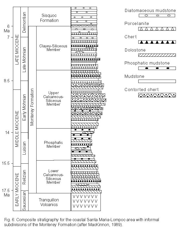
Although famous for its overall siliceous composition, the Monterey Formation is quite heterogeneous over scales ranging from laminations to formational members (Isaacs, 1980; Pisciotto and Garrison, 1981). Based chiefly on composition, the Monterey Formation has been locally divided into informal stratigraphic members; the most commonly cited schemes are the 5 members for the Santa Barbara coast (Isaacs, 1983), the 3 members for the Salinas and Santa Maria basins (Pisciotto and Garrison, 1981), and the 4 members for the coastal Santa Maria area (MacKinnon, 1989). We use the latter here (Figure 6). Appreciable quantities of pure diatomite or chert are found only in the middle part of the formation (Behl, 1994; Bramlette, 1946; Dunham and Blake, 1987; Grivetti, 1982), specifically the Upper Calcareous-Siliceous member. Compositional variation in within the Monterey resulted from the complex interaction of climate, tectonics, bathymetry, sea level, and surface water productivity during the middle to late Miocene (Ingle, 1981). Cyclic bedding is characteristic of most of the Monterey (Plate 10c). Depositional onset of the cherty facies along the California coast was clearly time transgressive, starting north of San Francisco at 14.7 to 15.0 Ma in the Bodega and Outer Santa Cruz basins, reaching the Santa Maria basin 2 m.y. later (12.7 Ma) (White, 1989). In the Santa Maria basin, these most siliceous deposits are of late Middle to early Late Miocene age (Early Mohnian benthic foraminiferal, D. hustedtii - D. lauta subzones B and C (Barron, 1986; White, 1989)).
In addition to the stratigraphic restriction, significant thicknesses of dense, vitreous chert developed only in the purer biogenic sediments of the geographically outer basins. Cherts are rare in the medial basins, and almost nonexistent in the most proximal San Joaquin basin. In most locations, relatively high sedimentation rates for biogenous sediments, often exceeding 100 m/m.y. (>400 m/m.y. precompaction sedimentation rates), rapidly and deeply buried Monterey sediments, accelerating the rate of silica diagenesis. Other locations, such as here at the Grefco quarry, were not buried deeply enough to convert opal-A phase diatomaceous sediments to their diagenetic equivalents. Because of late Neogene uplift, we have the opportunity to examine many of the early stages of burial diagenesis which reveal the intimate interaction of diagenesis, deformation, and fluid flow in the Monterey Formation.
We will visit two locations within the Grefco quarry and one just outside at the top of the access road. Here, the extremely pure diatomaceous sediments are mined for their filtering, abrasive, and inert mixing properties (Jenkins, 1982). Most of the beer and wine that you may drink has been filtered through the delicate frustules of billions of Miocene diatoms! This siliceous interval was deposited during the early Mohnian stage, between 9-10 Ma (J. Barron, U.S.G.S., pers. comm., 1992), and correlates with the most chert-rich intervals of coastal sequences at Mussel Rock, Lions Head, and Point Pedernales. These Monterey diatomites were mapped as Sisquoc on the Dibblee maps of the area. Structurally, these deposits have been folded into a series of roughly east-west trending synclines and anticlines. Variations in burial depth due to the development of the structure produced considerable lateral differences in diagenetic grade. Within the quarry, high-grade diatomite ore can be laterally traced into "worthless" opal-CT chert. Within the mine, we will see the significance of the opal-A to opal-CT transformation. We will examine the initial transformation to quartz-phase chert on the access road and, if time allows, observe black glassy quartz cherts at a possible stop where the access road joins the highway.
Relationships between diagenesis and deformation
The diatomaceous sediments here are extremely porous, ranging from ~65% to ~83%. Although quite rigid for their high porosity, they can still be easily shortened by sediment load compaction or tectonic strain. Within the diatomite, the earliest formed opal-CT cherts are found as thin interbedded laminations, contorted brecciated beds, and nodular horizons. Most opal-CT cherts formed by the local concentration of advected or diffused silica as pore-filling or fracture-filling cement within porous opal-A diatomite, as opposed to the in situ silica phase transformation responsible for the diagenesis of porcelanite and siliceous mudstone (Behl, 1994). Oxygen isotopic compositions and structural relationships show that these opal-CT cherts formed rapidly and shallowly, within a few hundred meters of the sediment-water interface and at temperatures between 2-33°C (Behl, 1992). Early chertification thus placed the hard, relatively incompressible, brittle chert in intimate association with the highly porous diatomite. Consequently, the two lithologies display markedly different styles of deformation when experiencing burial or tectonic strain (Behl, 1994; Grivetti, 1982).
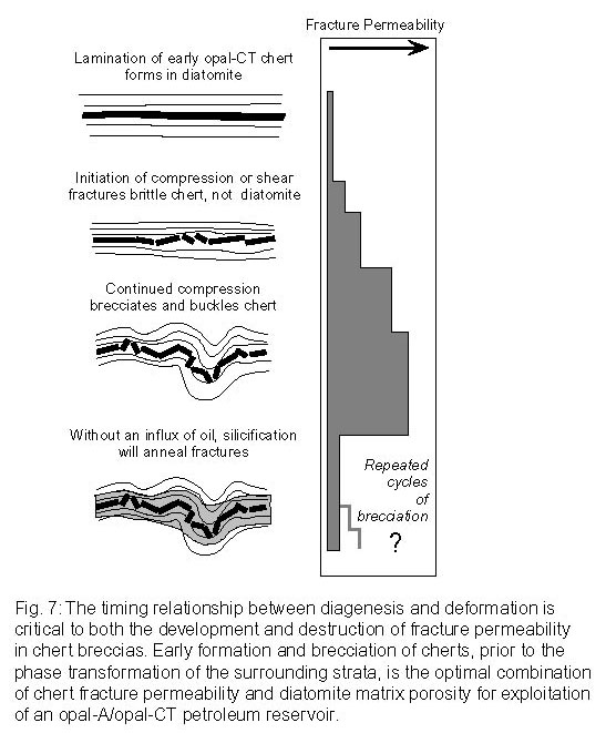
Brittle deformation of chert can be observed in incremental steps from the initial fracturing of thin laminations to the development of complex brecciated horizons. As average matrix permeability is exceedingly low for most Monterey lithologies (<<1 millidarcy) (Isaacs, 1980; MacKinnon, 1989), fracture permeability is critically important as a conduit for fluid flow carrying dissolved silica. Consequently, brittle deformation and brecciation commonly results in repeated cycles of embrittlement, fracturing, enhanced permeability, cementation, and re-embrittlement, which ultimately contributes abundant fracture-filling silica to the total volume of the rock (Figure 7). Many apparently undeformed chert beds actually contain 5-40% fracture-filling silica (opal-CT, microcrystalline quartz, or chalcedony). Chert breccias generally record net dilation by the rotation and translation of individual fragments, each rigid and angular enough to support open fractures under the lithostatic or tectonic load (Plate 10d). If formation fluids are saturated with respect to quartz, chalcedony or opal-CT, then fractures will ultimately be cemented with diagenetic silica. However, if brecciation is followed by an influx of oil, fractures will remain uncemented and chert breccias can provide high-permeability petroleum reservoirs (Figure 7).
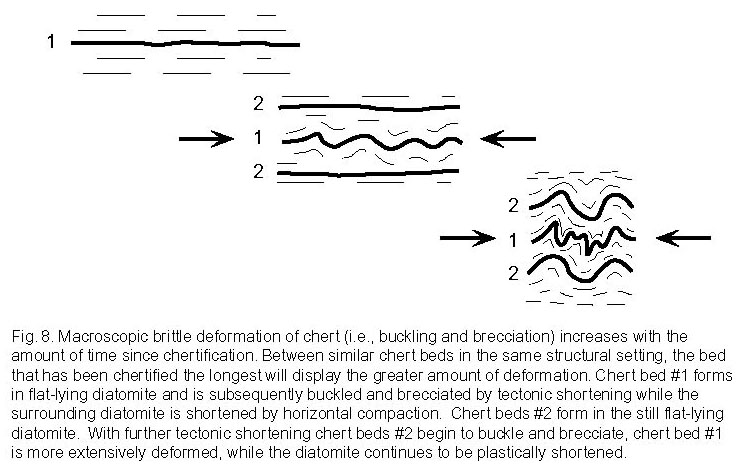
A unique style of intraformational folding is restricted to chert beds in the Monterey Formation and not displayed by any other lithologies (Bramlette, 1946; Dunham and Blake, 1987; Grivetti, 1982). Intensely contorted and brecciated chert beds occur between unfolded layers of diatomite, porcelanite, mudstone, or dolostone at many locations in the Santa Maria basin (Plate 10e). In the Santa Maria area, contorted cherts are characterized by upright, symmetric to asymmetric folds, generally parallel to large-scale tectonic structures but with no structurally consistent sense of vergence (Grivetti, 1982). Folding is accomplished by buckling and brecciation of the chert beds into small, tabular fragments which are free to independently rotate and slide (Behl, 1992; Behl, 1994; Dunham and Blake, 1987). Because this volume conservative (or even dilational) style of deformation is dependent upon the strength and brittleness of the chert, the amount of visibly recorded strain acts to measure the relative length of time since initial chertification (Figure 8). For example, an early formed chert bed is forced to brittlely accommodate compressive strain by buckling and brecciating while surrounding diatomite deforms ductiley. If a nearby layer of diatomite is then silicified to chert, it will have previously shortened by compaction, but only then start to deform brittlely by fracturing and rotation of independent fragments.
Possible additional stop at Highway 1
Unless subsurface porosity becomes saturated with oil, further diagenesis (fracture- and pore-filling cementation and opal-CT to quartz transformation) continues to modify the physical properties of the chert breccias. With greater burial and lower concentrations of dissolved silica in the formation waters, precipitation of quartz phase cement in fractures and aggrading neomorphism of opal-CT to microcrystalline quartz will obliterate most textural evidence of brittle deformation. Once porous breccias will become welded together and folded chert beds appear to have been ductilely folded (Plate 10f). This stop show folded and fractured cherts that have mostly converted to the quartz phase. Here, quartz phase portions of the cherts are black, opal-CT zones are gray to white. Note the cross-cutting relationships between both the fractures and diagenetic transformation fronts. Depending on the degree of cementation, fractures act either to accelerate or to block the diagenetic transformation.
Return down the quarry access road to Hwy. 1. The possible additional stop to examine the black and white, quartz and opal-CT cherts is immediately to the west on the highway. Be extremely careful if you stop here. Turn right and drive west only 0.7 miles towards Lompoc (and Jalama Road). Pull off road and examine the road cut outcrops to the north.
STOP 4: HIGHWAY 1 ROADCUT
KEY POINTS:
- Overall limited development of chert beds in less siliceous stratigraphic interval
- Multiple orientation of faults in laminated muddy diatomites
- Fluid flow along faults indicated by silicification along faults and into more permeable layers of diatomite
- Silicification both predates and postdates last fault movements
- Note that diffuse, bedding-scale silicification does not produce thin individual chert laminations that become highly brecciated when deformed
Fault-related cross-cutting silicification and fluid flow
At Stop 3, we examined cherts that formed along preferred stratigraphic horizons and became brecciated due to the great rheologic contrast between chert and diatomite. Fractures in the chert bed provides avenues for bedding-parallel fluid movement that are many orders of magnitude more permeable than the host diatomaceous sediments. Such stratigraphic conduits are undoubtedly important for fluid flow up the flanks of anticlinal and monoclinal structures, especially if their deformation was enhanced by flexural slip along bedding. At this stop, we observe a different kind of fluid flow and silicification. Overall, the stratigraphic sequence exposed here is composed of less pure diatomaceous sediments which are less likely to form early opal-CT cherts.
Silicification at this location is controlled by fluid flow along the prominent faults displayed in outcrop. Note that an irregular decimeter-wide zone along many of the faults is silicified to chert (Plate 10g). Widely-spaced laminations within this zone show that silicification started early, prior to subsequent compaction of the unsilicified lithologies. Silicification also captures offset of primary features along the faults, as well as later fault movement that has offset the secondary silicified beds (Plate 10h). The geometry (pinch-and-swell) of the few prominent silicified chert/porcelanite beds that extend across the outcrop clearly show that additional silica was fed by fluid from the fault. Here, with smaller-scale faults were likely fed by more stratigraphically limited chemistry as opposed to the major faults examined at Arroyo Burro and Jalama beaches, mineralization is apparently limited to precipitation of opal-CT silica.