Faults and Geomodels
Synopsis: Develop 3D interpretations and characterizations and geomechanical assessment of faults and disposal zone hydraulic continuity and capacity within sedimentary basins of Texas beginning with the Ft. Worth Basin
Project Status: Active
Funding Source: 100% TexNet
Research Leaders: Peter Hennings, Johnathon Osmond, Robin Dommisse, Katie Smye, and Chris Zahm.
Project Start: 3Q2016
Project Interface: Project interfaces closely with Hydrology: Fluid Budget Protocols, Data and Analysis, Basin-Scale Assessment of Fault Reactivation and Seismicity Potential, Geomechanics of Fault Reactivation, Coupled Fluid Flow and Geomechanical Modeling, Seismic Hazard and Risk Assessment - Shaking Intensity, and Multi-Institutional and Industrial Collaboration for Geomechanical and Seismicity Assessment of the Ft. Worth Basin
Expected research outcomes:
- 3D models of faults and fault systems from subsurface and outcrop
- Fault geometric and spatial characterizations
- Estimations of fault reactivation potential
- Geomodels of injection zones and estimations of hydraulic connectivity
Reactivation of the faults is what produces earthquakes. Therefore identifying the existence of faults in seismically sensitive basins and ascertaining their geomechanical characteristics is vital to assessing seismicity in Texas. Recent experience in Oklahoma and elsewhere shows that the vast majority of potentially induced earthquakes has occurred on previously unmapped faults therefore it is critical to compile all possible indicators of faults to develop interpretations of fault geometry, timing, depth/height from basement into the sedimentary cover. Fault system and growth characterizations to be studies include, length, offset, gradients in displacement, linkage geometries, spacing, growth behavior, and reactivation history. Data to be considered include published information, industry seismic data (as available), seismicity data and characteristics, and outcrop. This work will begin in the region of the Ft. Worth Basin and then move to other areas of Texas such as the Permian Basin, Panhandle, and Eagle Ford play area.
The southwest and especially the northeast flanks of the Llano uplift host outcrops of normal and oblique-slip faults that are the southwest continuation of faults from the Ft. Worth Basin. These faults will be characterized for their outcrop geometry to construct a 3D model from which fault system geometry, offset relationships, and growth characteristics can be analyzed. In locations of suitable outcrop quality, detailed characterizations of small-scale brittle deformation characteristics will be collected to assess the hydraulic architecture of fault and fracture zones and mechanisms of vertical connectivity from the sediments into basement. These outcrop characterizations will be used generically to inform models for fault characteristics with the Ft. Worth Basin.
The deterministic data obtained from subsurface study in the Ft. Worth Basin and informed by outcrop data from the flanks of the Llano uplift will be used to stochastically generate realizations of the fault spatial and volumetric intensity within the Ft. Worth Basin as input into fluid flow and geomechanical models within other TexNet-CISR projects.
With 3D deterministic models and stochastic realizations of faults within the Ft. Worth Basin and then elsewhere, we will conduct fault stress analysis to assess the static sensitivity of faults to reactivation. This task will utilize in situ stress analysis as being undertaken by Stanford’s SCITS research group. Once basinal pore pressure data is available, assessments of area-specific fault reactivation hazard will be assessed.
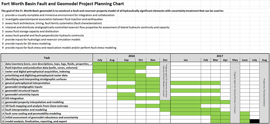
Supporting fault characterization, hydrologic modeling, and reservoir and geomechanical modeling projects it is a task within this project to build a 3D geomodel of the Ft. Worth Basin with the purpose of evaluating the structure and hydraulic capacity and continuity of the Ellenburger Fm which will be used to QC critical input data and to serve as a foundation for fluid flow and geomechanical modeling efforts.

