STATUS AND TRENDS OF INLAND WETLAND AND AQUATIC HABITATS
This report presents results of a status-and-trend study of the upper Texas coast along the inland wetland system from the Sabine River to Anahuac National Wildlife Refuge (NWR). The Beaumont-Port Arthur area is characterized by Sabine Lake, a small bay-estuary system separated from the Gulf of Mexico by a modern strandplain-chenier system. The Sabine and Neches Rivers discharge into Sabine Lake. The study area encompasses most of the mainland between the Gulf Intracoastal Waterway (GIWW) and the Texas General Land Office (GLO) Coastal Management Program (CMP) boundary, an area that is located within Orange, Jefferson, and Chambers Counties. Natural environments include wetlands, tidal flats, riparian woodlands, and bay shorelines.
The bay-estuary study area along the upper Texas coast contains the most extensive contiguous marshland along the Texas Gulf Coast. Most marshland falls within the McFaddin NWR, Anahuac NWR, and J. D. Murphree Wildlife Management Area (WMA). Extensive freshwater marshes and ponds characterize this area. Most of the freshwater marshes that are part of the McFaddin NWR occur inland of the GIWW (Dean Bossert, Refuge Manager, Personal Communication, 2006).
Status, 2004
Major palustrine habitats in the study area include fresh marshes and open water. Forests are next in areal distribution. Estuarine marshes are limited in extent. The primary habitat mapped in the fresh, open water system is the lacustrine, which consists of diked and leveed containment areas.
In 2004, wetland and aquatic habitats were dominated by palustrine marshes, with a total area of 35,876 ha (88,654 acres), followed by estuarine open water (ow) totaling 18,043 ha (44,585 acres), and forest/scrub-shrub at 12,316 ha (30,434 acres). Estuarine marsh covered 8,759 ha (21,644 acres). Lacustrine flats and open water had a total area of 4,188 ha (10,349 acres), and rivers 3,491 ha (8,627 acres). Palustrine habitats, consisting mostly of water and some flats, had a total area of 2,900 ha (7,166 acres).
Trends
Palustrine marshes are by far the dominant class of emergent wetlands in the upper-coast study area; therefore, for simplification and to reduce apparent changes due to interpretation, emergent wetland classes in the trend analysis were combined. From 1956 through 2004, emergent wetlands (marshes) increased from about 44,104 ha (108,983 acres) to 44,635 ha (110,296 acres), a gain of approximately 531 ha (1,312 acres) (Table 1; Fig. 1 & 2). Marsh area fluctuated through the study time period. The rate of marsh gain from 1956 to 1979 was 56 ha/yr (138 acres/yr), and from 1979 to 2004, marsh losses were about (–)30 ha/yr (74 acres/yr). Similarly, estuarine open water and flats experienced a fluctuation in area through time. The gain in estuarine open water was approximately 2,074 ha (5,125 acres). Rates of change in estuarine open water were about (+)139 ha/yr (344 acres/yr) during the earlier period and (–)45 ha/yr (111 acres/yr) during the later period. The overall estuarine open-water trend rate (1956–2004) was a gain of 43 ha/yr (106 acres/yr). The area of forest and scrub-shrub decreased substantially through time, from 19,506 ha (48,200 acres) in 1956 to 12,316 ha (30,434 acres) in 2004. Rates of change in forest were about (–)355 ha/yr (877 acres/yr) during the earlier period and (+)39 ha/yr (96 acres/yr) during the later period. Freshwater and flats increased in area from 10,397 ha (25,691 acres) in1956 to 10,580 ha (26,144 acres) in 2004, a gain of about 183 ha (452 acres).
|
Habitat |
1950's |
1979/83 |
2004 |
|||
|
|
ha |
acres |
ha |
acres |
ha |
acres |
|
Palustrine marsh |
37,040 |
91,489 |
36,033 |
89,002 |
35,876 |
88,614 |
|
Estuarine ow |
15,603 |
38,539 |
18,518 |
45,740 |
18,043 |
44,566 |
|
Forest |
19,506 |
48,180 |
11,335 |
27,998 |
12,316 |
30,421 |
|
Estuarine marsh |
7,064 |
17,448 |
9,353 |
23,101 |
8,759 |
21,635 |
|
Lacustrine ow |
6,508 |
16,075 |
5,714 |
14,114 |
3,672 |
9,069 |
|
River |
3,062 |
7,563 |
3,653 |
9,023 |
3,491 |
8,624 |
|
Palustrine ow |
828 |
2,045 |
2,580 |
6,373 |
2,439 |
6,025 |
Table 1. Total area of major habitats in 1956, 1979/83, and 2004.
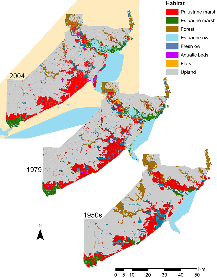
Figure 1. Map showing distribution of major wetland and aquatic habitats in 2004, 1979/83, and 1956 in the upper coast study area.
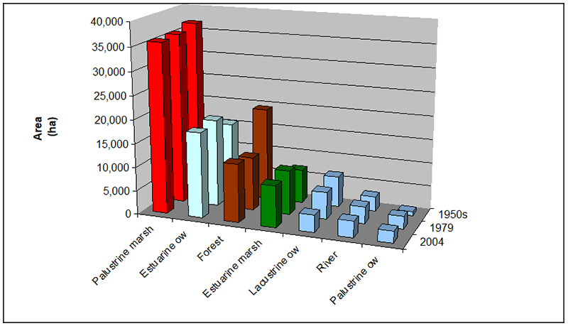
Figure 2. Areal distribution of major habitats in the study area in 1956, 1979/83, and 2004.